Multi-rotor UAV altitude geographical surveying and mapping system

A technology of multi-rotor UAV and UAV, which is applied in the field of geographic surveying and mapping, can solve problems such as inability to display, achieve the effects of reducing occupied space, facilitating surveying and mapping calculations, and improving comprehensiveness

Inactive Publication Date: 2019-10-22
WUCHANG UNIV OF TECH
View PDF10 Cites 2 Cited by
  • Summary
  • Abstract
  • Description
  • Claims
  • Application Information

AI Technical Summary

Problems solved by technology

[0004] Based on the technical problem that the existing UAV surveying and mapping system cannot accurately display the proportional coefficient between the surveying and mapping ratio in the video and the geographical ratio of the entity in reality in the control center, this invention proposes a multi-rotor UAV Height Geographic Mapping System

Method used


Image

  • Multi-rotor UAV altitude geographical surveying and mapping system
  • Multi-rotor UAV altitude geographical surveying and mapping system
  • Multi-rotor UAV altitude geographical surveying and mapping system

Examples


Embodiment Construction

[0021] The following will clearly and completely describe the technical solutions in the embodiments of the present invention with reference to the accompanying drawings in the embodiments of the present invention. Obviously, the described embodiments are only some, not all, embodiments of the present invention.

[0022] In describing the present invention, it should be understood that the terms "upper", "lower", "front", "rear", "left", "right", "top", "bottom", "inner", " The orientation or positional relationship indicated by "outside", etc. is based on the orientation or positional relationship shown in the drawings, and is only for the convenience of describing the present invention and simplifying the description, rather than indicating or implying that the referred device or element must have a specific orientation, so as to Specific orientation configurations and operations, therefore, are not to be construed as limitations on the invention.

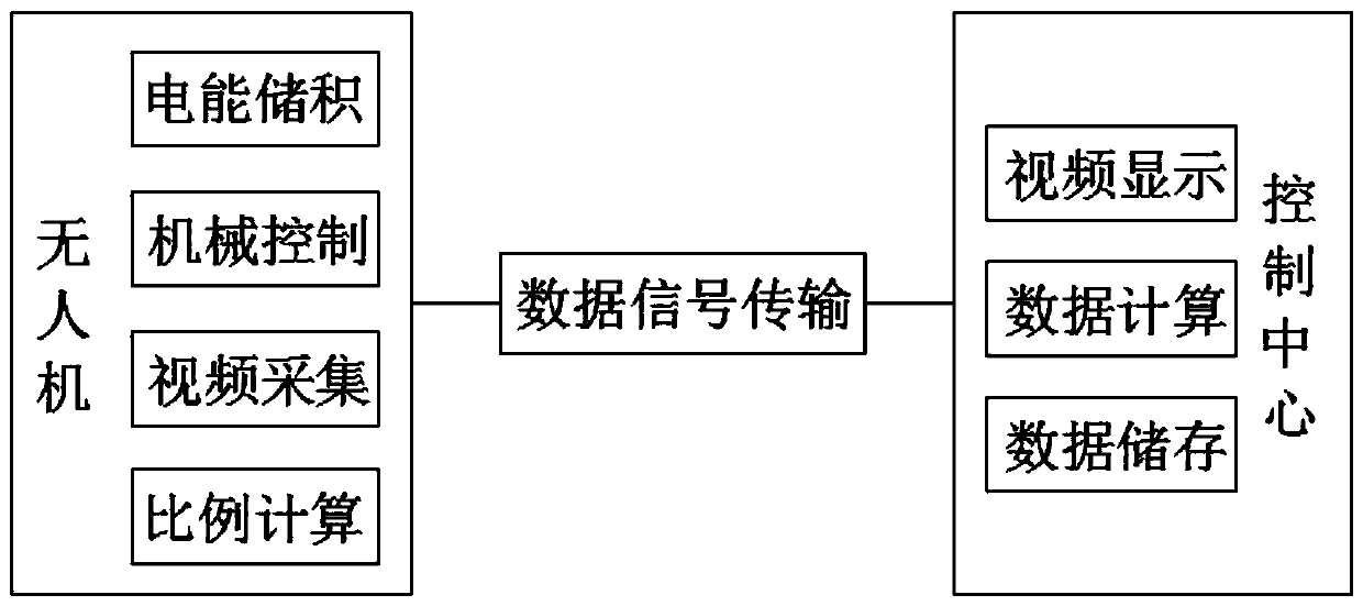
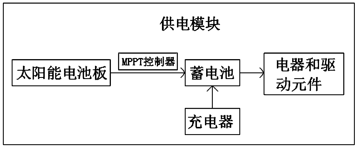
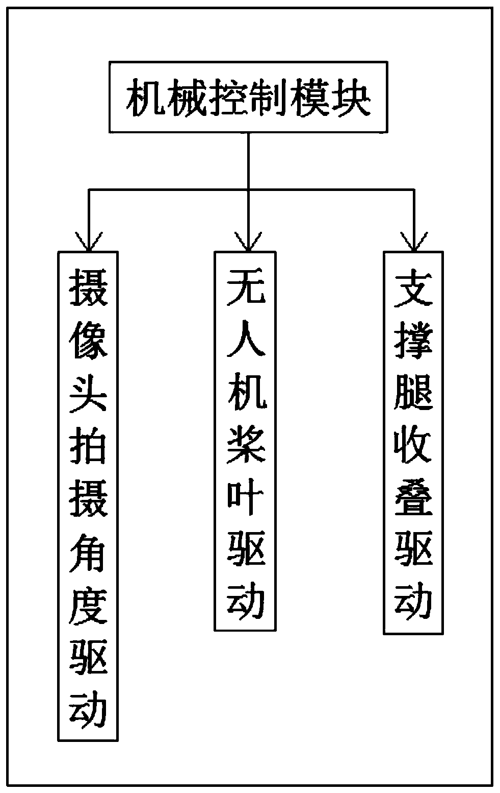
[0023] refer to Figure ...


PUM


Abstract

The invention belongs to the technical field of geography surveying and mapping and in particular to a multi-rotor UAV altitude geographical surveying and mapping system. In consideration that an existing UAV surveying and mapping system cannot accurately display a scale factor of the surveying and mapping scale in a video and the geographical scale of an entity in reality in a control center, themulti-rotor UAV altitude geographical surveying and mapping system comprises a UAV and a control center. The UAV includes a GPS chip, a solar panel, a mechanical control module, a surveying and mapping control module, a battery, a cameras a UAV body, a support leg and a processor, wherein the solar panel is fixedly installed on the outer wall of the top side of the UAV body by bolts. In the present invention, the multi-rotor UAV altitude geographical surveying and mapping system is provided with the solar panel which can convert the solar energy into electrical energy and store the electricalenergy in the battery during the operation of the UAV so as to supply power to the battery, thereby achieving an energy-efficient and environment-friendly effect.

Description

technical field [0001] The invention relates to the technical field of geographic surveying and mapping, in particular to a multi-rotor UAV altitude geographic surveying and mapping system. Background technique [0002] Surveying and mapping is literally understood as surveying and drawing. It is based on computer technology, photoelectric technology, network communication technology, space science, and information science. It is based on global navigation satellite positioning system (GNSS), remote sensing (RS), and geographic information system (GIS). The technical core is to select the existing feature points and boundaries on the ground and obtain the graphics and position information reflecting the current situation of the ground through measurement means for engineering construction, planning and design and administrative management. [0003] At present, drones are used in the process of height geographic surveying and mapping. The existing drone surveying and mapping ...

Claims


Application Information

Patent Timeline
Patent Type & Authority Applications(China)
IPC IPC(8): G05D1/10G01C11/02
CPCG05D1/101G01C11/02
Inventor 安庆柳立生欧阳玉华王金玲
Owner WUCHANG UNIV OF TECH
Why Eureka
Try Eureka