Unmanned aerial vehicle aerial photography image automatic generating line drawing method based on desert area

A technology of automatic generation and line drawing, applied in the direction of photo interpretation, navigation calculation tools, etc., can solve problems such as low operation efficiency, and achieve the effects of improved efficiency, high precision, and high degree of automation

Inactive Publication Date: 2019-11-01
XIAN CHANGQING TECH ENG +1
View PDF6 Cites 13 Cited by
  • Summary
  • Abstract
  • Description
  • Claims
  • Application Information

AI Technical Summary

Problems solved by technology

[0005] The embodiment of the present invention provides a method for automatically generating line drawings based on aerial images...

Method used


Image

  • Unmanned aerial vehicle aerial photography image automatic generating line drawing method based on desert area
  • Unmanned aerial vehicle aerial photography image automatic generating line drawing method based on desert area
  • Unmanned aerial vehicle aerial photography image automatic generating line drawing method based on desert area

Examples


no. 1 approach

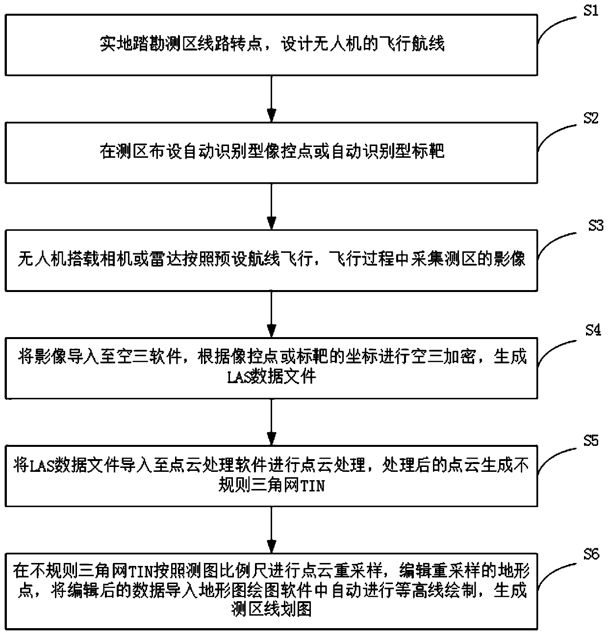
[0042] The present invention provides a method for automatically generating line drawings based on drone aerial images in desert areas, such as figure 1 shown, including the following steps:

[0043] Step S1, visit the survey area on the ground, and design the flight route of the drone;

[0044] Step S2, laying out automatic recognition type image control points or automatic recognition type targets in the survey area;

[0045] Step S3, the UAV is equipped with a camera or radar to fly according to a preset route, and collects images of the survey area during the flight;

[0046] Step S4, import the image into the aerotriangulation software, perform aerotriangulation encryption according to the coordinates of the image control point or the target, and generate the LAS data file;

[0047] Step S5, importing the LAS data file into point cloud processing software for point cloud processing, the processed point cloud generates an irregular triangulation network TIN;

[0048] St...

no. 2 approach

[0057] The present invention provides a method for automatically generating line drawings based on drone aerial images in desert areas, such as figure 1 shown, including the following steps:

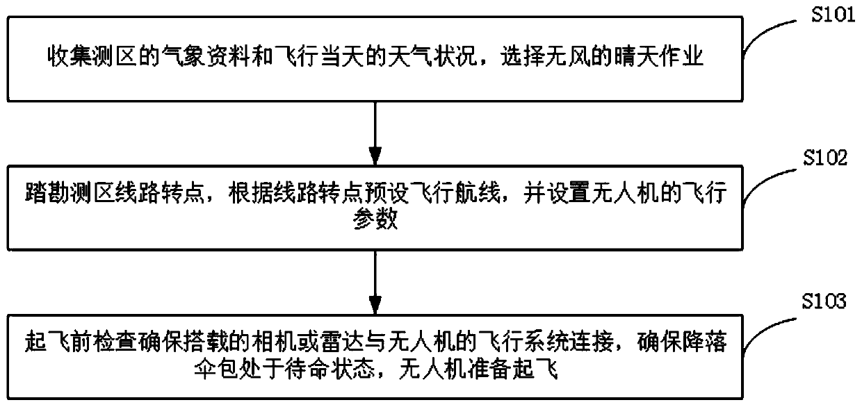
[0058] Step S1, visit the survey area on the ground, design the flight route of the UAV, refer to figure 2 , including the following steps:

[0059] Step S101, collecting meteorological data in the survey area and the weather conditions on the day of flight, and selecting a sunny day with no wind for operation;

[0060] Step S102, step on the route in the survey area, preset the flight route according to the route transfer point, first select the route, collect the transfer point coordinates along the route, and fly the UAV according to the route transfer point coordinates when flying, and then set the UAV flight parameters;

[0061] Step S103, check before takeoff to ensure that the camera or radar onboard is connected to the flight system of the drone, ensure that the parachute bag...

no. 3 approach

[0070] The difference from the first embodiment is that the automatic recognition type image control point or the automatic recognition type target described in step S2 of this embodiment is a telescopic image control point or Telescopic target, just open the image control point or target when used on site.

[0071] The structure of the telescopic image control point or the telescopic target refers to the specific content of the application document CN201811267479.X. The purpose of coating the surface of the image control point or the target with a high-brightness reflective film or a high-brightness reflective paint is to enhance reflection and increase image quality. The recognition degree of the control point position in the image.

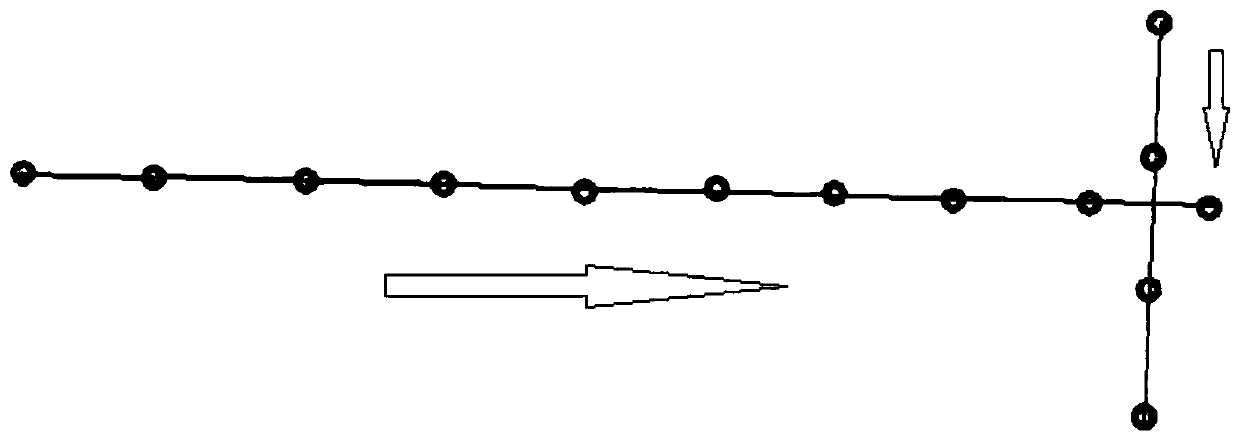
[0072] In addition, the image control points or targets are laid out in the way of 8 baselines and a pair of points (8 baselines, a pair of image control points), and checkpoints are added in the middle, such as image 3 As shown, the points w...


PUM


Abstract

The invention provides an unmanned aerial vehicle aerial photography image automatic generating line drawing method based on a desert area. The method comprises the following steps: designing a flightroute of an unmanned aerial vehicle; arranging an automatic identification type image control point or an automatic identification type target in a measuring area; an unmanned aerial vehicle carriedcamera or radar flying and acquiring images according to a preset airline; importing the images into aerial triangulation software to carry out aerial triangulation, and generating an LAS data file; importing the LAS data file into point cloud processing software to carry out point cloud processing and generating a TIN (Triangulated Irregular Network); performing point cloud resampling on the TINaccording to a mapping scale, editing a resampled terrain point, and importing the edited data into topographic map mapping software to automatically carry out contour line drawing and generating measuring area line drawing. According to the method in the invention, the unmanned aerial vehicle is used for measuring a target area, after the images are spliced, the method is not performed accordingto the traditional unmanned aerial vehicle mapping process, the cloud data processing flow is combined to directly generate the images into point cloud, the point cloud is resampled, an elevation point is plotted so as to manufacture a DLG (Digital Line Graphic), the precision is higher, and the efficiency is higher.

Description

technical field [0001] The invention belongs to the technical field of photogrammetry, and in particular relates to a method for automatically generating a line drawing based on an aerial image of a drone in a desert area. Background technique [0002] At present, UAV aerial photography is widely used in military reconnaissance, urban planning, land and water resource investigation, natural disaster monitoring, public security and national defense, and advertising photography, etc., and has a broad market demand. [0003] Usually, when UAVs measure topographic maps in desert areas, they first take pictures of the impact along the route according to the preset route, and then construct a three-dimensional model (image pair) or generate a three-dimensional real-scene model after being encrypted by aerial triangulation (air triangulation), and finally need to Technicians wear stereoscopic glasses to draw contour lines manually on the stereo model, or manually draw contour lines...

Claims


Application Information

Patent Timeline
IPC IPC(8): G01C21/20G01C11/34
CPCG01C11/34G01C21/20
Inventor 王研王万利何军方竹兵侯大勇李运海王治军秦晓刚杨绥院刘文龙张小鹏秦亮亮
Owner XIAN CHANGQING TECH ENG
Why Eureka
Try Eureka