Pit parameter measuring method

A technology of parameter measurement and tiankeng, applied in the directions of measuring devices, photogrammetry/video metrology, surveying and navigation, etc., can solve the problem of lack of tiankeng data support for development, utilization and protection, limitation of tiankeng classification, formation and evolution and Contrast research, measurement methods are difficult to quickly obtain Tiankeng landform series parameters and other issues, to achieve the effect of high accuracy, comprehensive measurement parameters, simple and efficient operation

Pending Publication Date: 2020-02-25
INST OF KARST GEOLOGY CAGS
View PDF2 Cites 3 Cited by
  • Summary
  • Abstract
  • Description
  • Claims
  • Application Information

AI Technical Summary

Problems solved by technology

[0003] The tiankeng is a huge negative terrain surrounded by steep cliffs. It is difficult to accurately and quickly obtain a series of tiankeng landform parameters by traditional measurement methods. Due to the lack of

Method used


Image

  • Pit parameter measuring method
  • Pit parameter measuring method
  • Pit parameter measuring method

Examples


Embodiment Construction

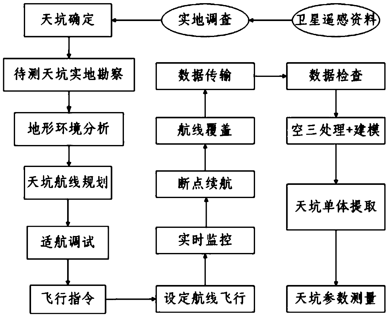
[0030] A step-by-step flow chart of a tiankeng parameter measurement method is shown in figure 1 In this embodiment, the DJI Phantom 4 (RTK) multi-rotor intelligent UAV is used as the flight platform, equipped with optical sensors to collect data, and the Shitang Tiankeng Group is taken as an example to measure the parameters of the Tiankeng. The specific implementation methods and steps are as follows:

[0031] 1) Determination of the data collection area: work on the map, interpret the tiankeng landform through satellite images, and determine the tiankeng landform measurement range; conduct field surveys on the tiankeng landform measurement range, and determine the tiankeng aerial photography data collection area, see figure 2 ;

[0032] 2) Analysis of airworthiness conditions: analyze the climate and terrain conditions of the data collection area, plan the flight route of the tiankeng topography UAV, and determine the airworthiness status of the UAV;

[0033] 3) UAV data ...


PUM


Abstract

The invention discloses a pit parameter measurement method and belongs to a landform measurement method. The method comprises the following steps of carrying out satellite remote sensing interpretation on pit landform; performing on-site investigation and determining a data acquisition area; performing airworthiness condition analysis and route planning; allowing an unmanned aerial vehicle carrying an optical sensor to perform data acquisition; transmitting a flight instruction and performing real-time monitoring, performing breakpoint endurance, performing course coverage, ending the data acquisition of the optical sensor, and transmitting acquired data; checking and processing the acquired data, processing the acquired data through aerial triangulation software, and establishing a three-dimensional model; performing pit monomer extraction; and measuring and analyzing various typical parameters of the pit three-dimensional landform model. According to the method, the pit full view including a pit opening, a pit wall and a pit bottom can be obtained, the problem that manual measurement cannot be conducted comprehensively is solved, full-coverage, high-precision and multi-view pit appearance data are obtained, the measurement parameters are comprehensive, the accuracy is high, and permanent measurement data are provided for protection, development and utilization of the pit appearance.

Description

technical field [0001] The invention relates to a method for measuring tiankeng parameters, in particular to a method for measuring tiankeng parameters based on an unmanned aerial vehicle. Background technique [0002] A tiankeng is formed by a karst cave hall in a carbonate rock area, with a depth and diameter of not less than 100 meters, and / or a volume greater than 1 million cubic meters, surrounded by or most of the surrounding walls and cliffs, and may have once communicated with an underground river karst cave extra large funnel. Tiankeng is a peculiar and spectacular negative terrain landscape in karst areas. It is distributed all over the world. There are more than 200 Tiankengs that have been discovered so far. China is the country with the largest distribution of Tiankengs in the world. In my country, they are mainly distributed from the south of Hanzhong to that Karst area north of the slope. From the definition, classification, and morphological development of t...

Claims


Application Information

Patent Timeline
IPC IPC(8): G01C11/00G01C11/04
CPCG01C11/00G01C11/04
Inventor 沈利娜张远海吕勇蒋忠诚陈伟海唐全生韦跃龙史文强张晶
Owner INST OF KARST GEOLOGY CAGS
Why Eureka
Try Eureka