Automatic driving drivable area detection method and system and vehicle

A detection method and driving area technology, applied in the field of drivable area detection based on road images, can solve the problems of strong data dependence, slow detection speed, lack of cost, etc., and achieve the effect of improving the detection method

Pending Publication Date: 2020-03-24
福瑞泰克智能系统有限公司
View PDF0 Cites 2 Cited by
  • Summary
  • Abstract
  • Description
  • Claims
  • Application Information

AI Technical Summary

Problems solved by technology

Since the monocular solution based on deep learning inevitably uses the GPU, real-time detection cannot be performed, and due to the lack of chip platforms and cost constraints, there are currently no products using this technology.
In

Method used


Image

  • Automatic driving drivable area detection method and system and vehicle
  • Automatic driving drivable area detection method and system and vehicle
  • Automatic driving drivable area detection method and system and vehicle

Examples


Embodiment Construction

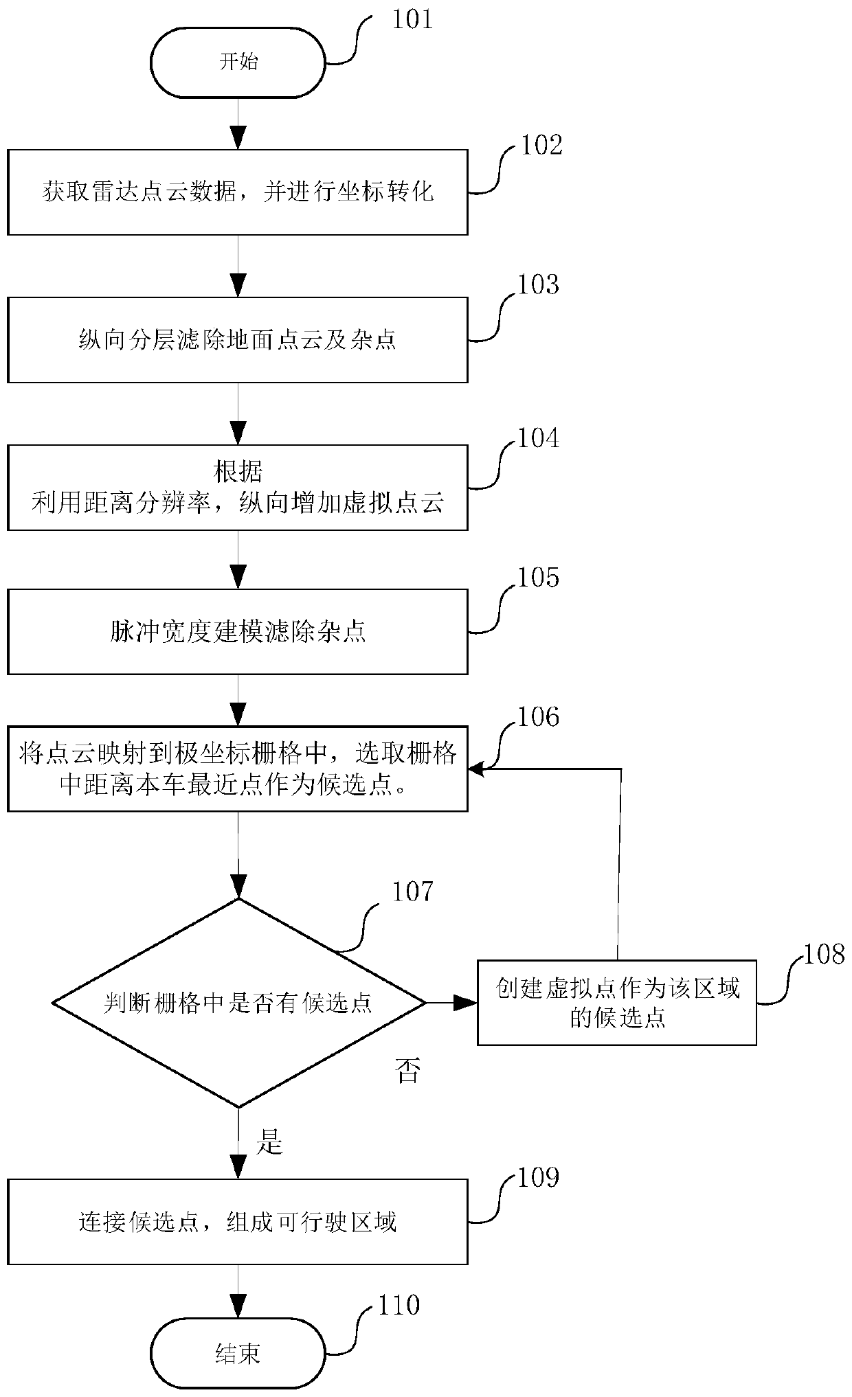
[0031] Combine below Figure 1-Figure 6 And the embodiments describe the present invention in further detail: the present invention is based on the data obtained by the laser radar sensor and is processed to obtain the required data:

[0032] The system equipment involved in the method includes: laser radar and computer. The lidar obtains environmental data from the Ethernet transmission processor for data processing, analyzes and obtains the original information of the point cloud, and transmits the original point cloud information to the drivable area for data processing, and maps the drivable area to the map module. The automatic driving system controls the driving of the vehicle according to the drivable area.

[0033] Such as figure 1 The flow chart of laser point cloud data processing is shown.

[0034] Step 101 starts the procedure.

[0035] Step 102 begins to obtain the original point cloud information through the laser radar, and performs coordinate transformation...


PUM


Abstract

The invention provides a method for detecting a drivable area of an automatic driving vehicle, and the method comprises the steps: obtaining original point cloud information through employing a laserradar, and carrying out the coordinate conversion; longitudinally layering the point cloud information to filter out ground point cloud and impurities; longitudinally increasing the virtual point cloud according to the obtained point cloud distance resolution to obtain second point cloud information; mapping the point cloud into a polar coordinate grid, judging whether the point cloud exists in the grid or not, if not, adding a virtual point as point cloud data, and selecting a point, closest to the vehicle, in the grid as a candidate point. According to the method, the detection of the drivable area can be realized under the condition of weak light, and meanwhile, the obtained boundaries are all reliable boundaries.

Description

Technical field: [0001] The invention relates to the technical field of automatic detection, in particular to a method, device and system for detecting a drivable area based on a road surface image. Background technique: [0002] In recent years, with the rapid development of the automobile industry, traffic accidents have become a global problem. Therefore, unmanned driving applications integrating automatic control, artificial intelligence, pattern recognition and other technologies have emerged. In the field of unmanned driving, drivable area detection is one of the key parts of unmanned driving technology. [0003] In the prior art, a monocular solution based on deep learning is mainly used to detect the drivable area. Since the monocular solution based on deep learning inevitably needs to use GPU, real-time detection cannot be performed, and due to the lack of chip platforms and cost constraints, no products using this technology have been released yet. In addition, f...

Claims


Application Information

Patent Timeline
IPC IPC(8): G01S17/931
Inventor 葛盼盼刘佳佳刘熙
Owner 福瑞泰克智能系统有限公司
Why Eureka
Try Eureka