River dry cutoff monitoring method and device based on multi-source remote sensing images

A remote sensing image and monitoring device technology, which is applied to computer-readable storage media and equipment, in the field of river dry-up monitoring based on multi-source remote sensing images, can solve the problem of inability to quantitatively determine the length of dry-up and dry-up, the index of dry-up ratio and the degree of dry-up, It is difficult to meet the problems of real-time processing of massive data in large areas and unfavorable environmental monitoring intelligence, so as to reduce the demand for image storage space, improve monitoring efficiency, and improve the level of intelligence.

Active Publication Date: 2020-06-12
MINISTRY OF ECOLOGY & ENVIRONMENT CENT FOR SATELLITE APPL ON ECOLOGY ENVIRONMENT
View PDF8 Cites 12 Cited by
  • Summary
  • Abstract
  • Description
  • Claims
  • Application Information

AI Technical Summary

Problems solved by technology

However, the extraction of river water surface area can only qualitatively judge the flow of rivers, and cannot quantitatively determine the dry-up length, dry-up ratio and other cut-off degree indicators.
[0006] At present, remote sensing technology based on visual interpretation can solve some disadvantages of existing remote sensing technology, but visual interpretation needs to rely on human eyes to extract ground object information from sub-meter-level fusion images, which has a large workload and low efficiency. The demand for image storage space is large, and it is difficult to meet the requirements of real-time processing of massive data in large areas, which is not conducive to improving the intelligent level of environmental monitoring

Method used


Image

  • River dry cutoff monitoring method and device based on multi-source remote sensing images
  • River dry cutoff monitoring method and device based on multi-source remote sensing images
  • River dry cutoff monitoring method and device based on multi-source remote sensing images

Examples


Embodiment 1

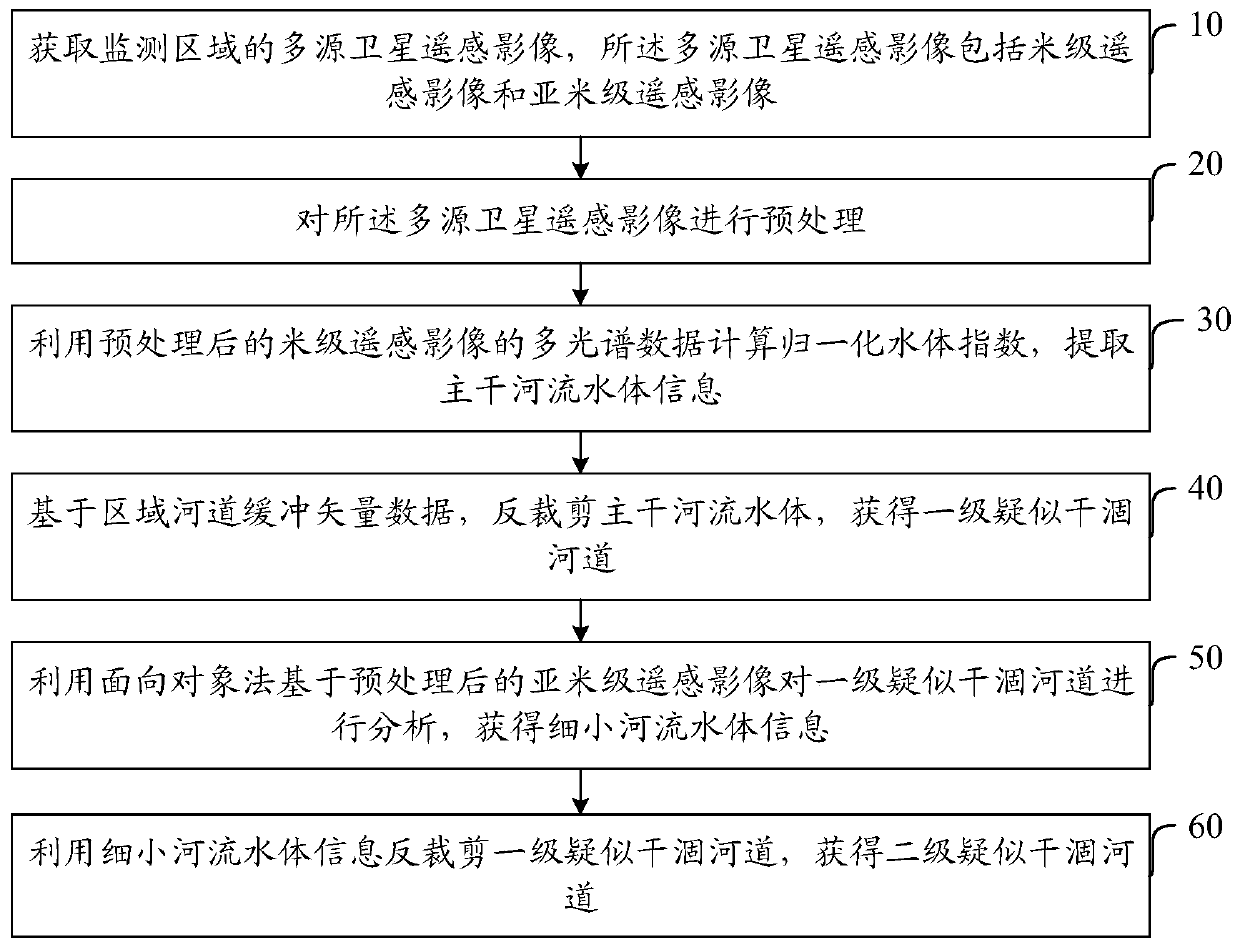
[0047] An embodiment of the present invention provides a method for monitoring river drying up and interruption based on multi-source remote sensing images, such as figure 1 As shown, the method includes:

[0048] Step 10: Obtain multi-source satellite remote sensing images of the monitoring area, including meter-level remote sensing images and sub-meter-level remote sensing images.

[0049] Multiple remote sensing image data acquired in the same area are multi-source remote sensing images, and multiple remote sensing images can be multi-platform, multi-temporal, multi-spectral, multi-sensor and multi-resolution remote sensing images.

[0050] The information provided by multi-source remote sensing image data is redundant, complementary and cooperative. Redundancy means that they have the same representation, description or interpretation of the environment or target; complementarity means that information comes from different degrees of freedom and are independent of each ot...

Embodiment 2

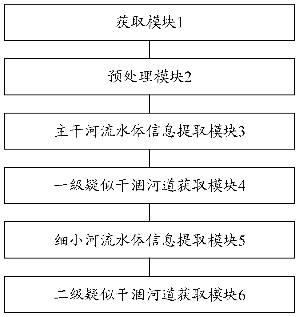
[0083] An embodiment of the present invention provides a monitoring device for river drying up and interruption based on multi-source remote sensing images, such as figure 2 As shown, the device includes:

[0084] The obtaining module 1 is used to obtain multi-source satellite remote sensing images of the monitoring area, and the multi-source satellite remote sensing images include meter-level remote sensing images and sub-meter-level remote sensing images.

[0085] The preprocessing module 2 is used for preprocessing the multi-source satellite remote sensing images.

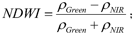
[0086] The main river water body information extraction module 3 is used to calculate the normalized water body index by using the multispectral data of the preprocessed meter-level remote sensing image, and extract the main river water body information.

[0087] The first-level suspected dry river channel acquisition module 4 is used to reverse-cut the water body of the main river based on the regional river ...

Embodiment 3

[0101] The methods described in the above-mentioned embodiments provided in this specification can implement business logic through computer programs and record them on a storage medium, and the storage medium can be read and executed by a computer to achieve the effect of the solution described in Embodiment 1 of this specification. Therefore, the present invention also provides a computer-readable storage medium for monitoring river drying up and interruption, including a memory for storing processor-executable instructions. When the instructions are executed by the processor, the multi-source remote sensing image based on embodiment 1 is implemented The steps of the monitoring method for river drying up and interruption.

[0102] The invention can realize the comprehensive, objective, efficient and dynamic supervision on the drying up of the river, and provide technical support for the evaluation, management, guarantee and restoration of the water environment of rivers and l...


PUM


Abstract

The invention discloses a river dry cutoff monitoring method and device based on multi-source remote sensing images, and belongs to the field of river monitoring, and the method comprises the steps: obtaining the multi-source satellite remote sensing images of a monitoring region, and the multi-source satellite remote sensing images comprise meter-level remote sensing images and sub-meter-level remote sensing images; preprocessing the multi-source satellite remote sensing image; calculating a normalized water body index by utilizing the meter-scale remote sensing image, and extracting trunk river water body information; based on the regional river channel buffer vector data, reversely cutting a main river water body to obtain a first-level suspected dry river channel; analyzing the first-level suspected dry riverway based on the sub-meter-level remote sensing image by using an object-oriented method to obtain fine river water body information; reversely cutting the first-stage suspected dry riverway by using the fine river water body information to obtain a second-stage suspected dry riverway. According to the invention, comprehensive, objective, efficient and dynamic supervision can be carried out on the dry cutoff condition of the river, and technical support is provided for river and lake water environment evaluation, management, guarantee and restoration.

Description

technical field [0001] The invention relates to the field of river monitoring, in particular to a method, device, computer-readable storage medium and equipment for monitoring river drying up and interruption based on multi-source remote sensing images. Background technique [0002] The water volume of river and lake water systems is the basis for the existence of water systems and plays an important role in the health of the water ecological environment. However, with global climate change and rapid social and economic development, the uneven distribution and irrational use of water resources have led to a large number of rivers in some areas of my country. The water volume in the section has decreased, or even dried up, causing many hazards such as a drop in groundwater level, an intensified water resource crisis, and a shrinking capacity of the water environment, seriously damaging the water ecological environment of the basin. In order to grasp the water resources of rive...

Claims


Application Information

Patent Timeline
Patent Type & Authority Applications(China)
IPC IPC(8): G06K9/00G06K9/36G06K9/62
CPCG06V20/182G06V10/20G06F18/2415G06F18/25
Inventor 王晨郅晓沙吴传庆马万栋殷守敬朱利王雪蕾孟斌徐丹李营杨红艳赵乾周亚明冯爱萍赵焕余嘉琦王楠
Owner MINISTRY OF ECOLOGY & ENVIRONMENT CENT FOR SATELLITE APPL ON ECOLOGY ENVIRONMENT
Why Eureka
Try Eureka