
Investigation information acquisition method and client for town territorial space planning requirements

A technology for spatial planning and information collection, applied in the field of information collection, which can solve the problems of insufficient data sharing, interaction and real-time performance within and outside the industry, lack of real-time interaction and transmission, and inability to meet the needs of remote system operation and user response, etc. To achieve the effect of improving the processing effect and capacity

Pending Publication Date: 2020-06-30
NANJING INST OF GEOGRAPHY & LIMNOLOGY
View PDF4 Cites 11 Cited by
  • Summary
  • Abstract
  • Description
  • Claims
  • Application Information

AI Technical Summary

Problems solved by technology

(2) The current survey information collection client is mainly limited to the recording and quick storage and query of data on the mobile phone, and lacks real-time interaction and transmission based on mobile 4G / 5G networks and other media with the remote management information visualization platform, resulting in internal and external data. The sharing, interactivity and real-time performance of the system are not enough to meet the response needs of remote system operators and users

Method used


Image

  • Investigation information acquisition method and client for town territorial space planning requirements
  • Investigation information acquisition method and client for town territorial space planning requirements
  • Investigation information acquisition method and client for town territorial space planning requirements

Examples


Embodiment 1

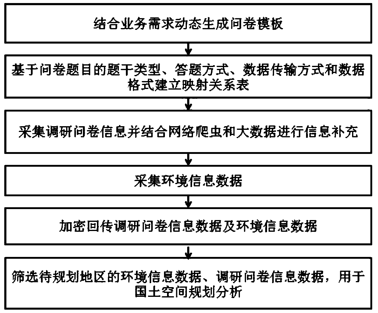
[0046] Such as figure 1 As shown, the present invention is oriented towards the research information collection method for the needs of township land space planning, including:

[0047] S01 Design questionnaire templates, dynamically generate questionnaire templates based on research objects under different business needs;

[0048] Specifically include:

[0049] Design questionnaire templates based on business needs;

[0050] Preset the basic questionnaire survey information form to collect the basic information of the respondents;

[0051] Call the questionnaire template based on the basic information of the surveyed person; or query the research record, call the questionnaire template based on the historical research record and push it to the researched person; if there is no questionnaire template or historical research record that can be called, push the existing template for selection, or Create a new questionnaire template.

[0052] S02 Establish a questionnaire info...


PUM


Abstract

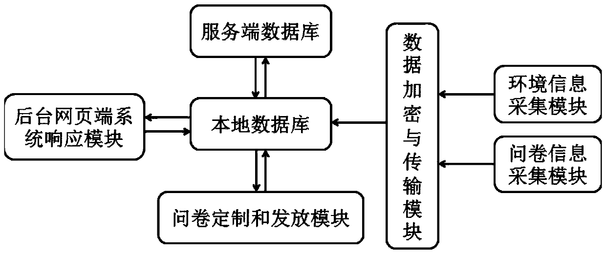
The invention relates to an investigation information acquisition method and a client for country and land space planning requirements of villages and towns. The method comprises the steps: employingthe data communication technology and the cloud computing technology, selecting an investigation object according to different investigation targets; collecting village and town resident subjective information through a questionnaire template design-template updating-online answering form type questionnaire module, establishing an investigation data standardization management method of investigation content-collection mode-calling interface-display mode, and integrating with surrounding environment objective information such as pictures and positions to form single complete investigation information; through data encryption and a wide-area mobile network, returning the information to a remote database in real time, and automatically standardizing the information into data form which can beread by a server database and can be displayed by a background webpage system. The method can comprehensively grasp subjective information such as resident willingness and environmental perception inrural territory and environmental protection related businesses, improves the integrity of investigation information, and enhances the intercommunity between front and back ends and indoor and outdoor information through real-time transmission.

Description

technical field [0001] The invention belongs to the technical field of information collection, and in particular relates to a survey information collection method and a client terminal oriented to the needs of township land space planning. Background technique [0002] On-the-spot surveys in townships have become a necessary basic survey method in carrying out important businesses in land, environmental protection, agriculture and other related departments (village and township land space planning, delineation of three districts and three lines, evaluation of resource and environment carrying capacity, poverty alleviation, etc.), and are also necessary to realize rural critical path to revitalization. Considering the huge differences and particularities of different townships in terms of geographical characteristics, living environment, development intentions, industrial structure, etc., before carrying out the above work, a large number of village visits, household surveys ...

Claims


Application Information

Patent Timeline
Patent Type & Authority Applications(China)
IPC IPC(8): G06Q50/26G06F40/186G06F16/41G06F16/28G06F16/27G06F16/182G06F16/29G06F16/951G06F16/955G06F16/957H04L29/06H04L29/08
CPCG06Q50/26G06F16/41G06F16/284G06F16/28G06F16/27G06F16/182G06F16/29G06F16/951G06F16/9554G06F16/9577H04L63/0428H04L67/02
Inventor 林晨许金朵马荣华候渲孙阳
Owner NANJING INST OF GEOGRAPHY & LIMNOLOGY
Learn More