Modeling method, system and device based on oblique photography and storage medium

A technology of oblique photography and modeling method, which is applied in 3D modeling, radio wave measurement system, photogrammetry/video measurement and other directions. Degree and visualization effect, the problem of ground object recognition effect, side structure or point cloud slope cannot be colored, etc.

Pending Publication Date: 2020-07-14
BEIJIG YUPONT ELECTRIC POWER TECH
View PDF6 Cites 10 Cited by
  • Summary
  • Abstract
  • Description
  • Claims
  • Application Information

AI Technical Summary

Problems solved by technology

[0004] However, the coloring effect of the orthographic photo of the lidar is mediocre, and it cannot achieve the level of texture detail, visualization effect, and ground object recognition effect matched by the high-precision model; The photograph is 2D, but the point cloud is 3D, and mutual correction cannot be performed to improve the accuracy of the model
In addition, oblique photography equipment usually only uses the aerial triangle algorithm for modeling, and does not use the high-precision data of lidar. Generally, the accuracy of oblique photography after processing is lower than that of laser point clouds. The industry also lacks a general algorithm and software tools. Realize the data fusion between the two and the mutual model correction between each other

Method used


Image

  • Modeling method, system and device based on oblique photography and storage medium
  • Modeling method, system and device based on oblique photography and storage medium
  • Modeling method, system and device based on oblique photography and storage medium

Examples


Embodiment 1

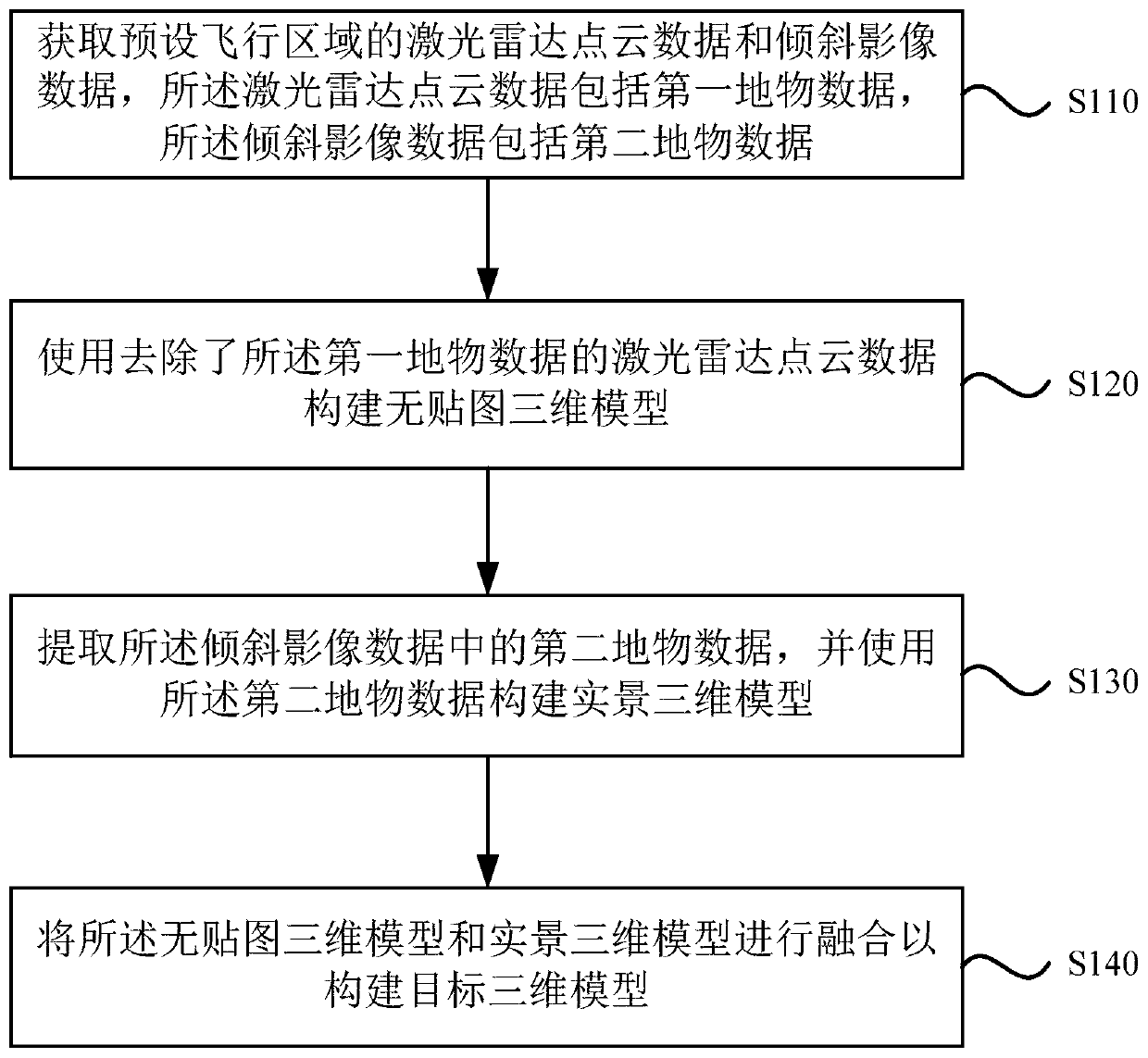
[0044] Such as figure 1 As shown, Embodiment 1 of the present invention provides a modeling method based on oblique photography, which includes:

[0045] S110. Acquire lidar point cloud data and oblique image data of a preset flight area, where the lidar point cloud data includes first feature data, and the oblique image data includes second feature data.

[0046]In this embodiment, the method can be executed using preset aerial survey equipment, which includes a laser radar, tilt camera, time synchronization module, inertial measurement module, control module and flight platform, and the flight platform is equipped with a laser radar and a tilt camera. photography camera. It can control the flight platform to fly in the preset flight area. The control module includes the main processor of the IMX6 industrial-grade chip, and receives the wireless control instructions sent by the staff through the 4G, SATA, USB and RS232 interfaces provided by the peripheral of the aerial sur...

Embodiment 2

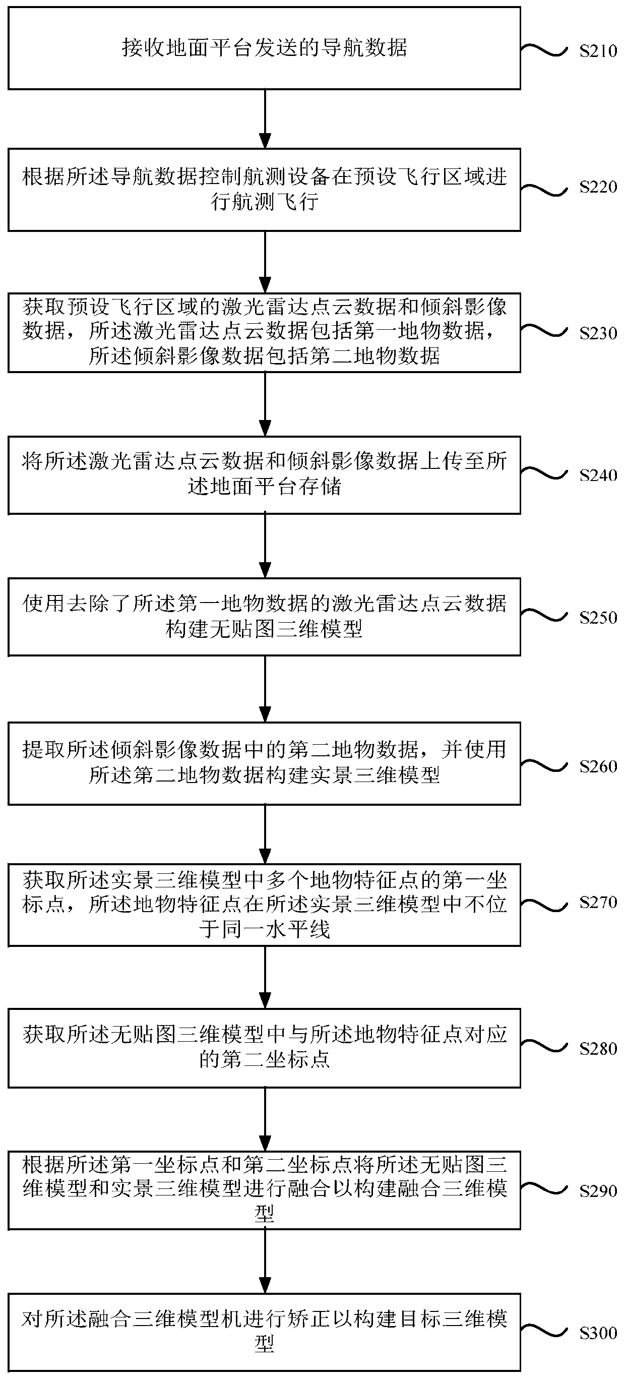
[0054] Such as figure 2 As shown, Embodiment 2 of the present invention provides a modeling method based on oblique photography. Embodiment 2 of the present invention is a further explanation on the basis of Embodiment 1 of the present invention. The method includes:

[0055] S210. Receive navigation data sent by the ground platform.

[0056] S220. Control the aerial survey equipment to perform aerial survey flight in a preset flight area according to the navigation data.

[0057] In this embodiment, the control module of the aerial survey equipment will receive the navigation data sent by the ground platform through the wireless communication interface provided by the aerial survey equipment. The navigation data is set by the staff, and the control module will synchronize the information to the inertial measurement module and the time synchronization module. , so that the aerial survey equipment can fly in the preset flight area according to the navigation data.

[0058] S...

Embodiment 3

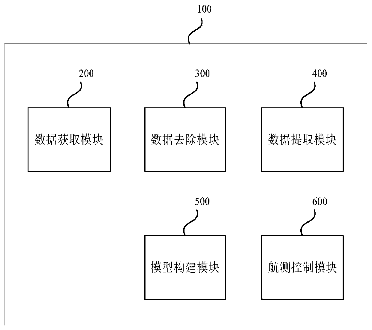
[0072] Such as image 3 As shown, Embodiment 3 of the present invention provides a modeling system 100 based on oblique photography. The modeling system 100 based on oblique photography provided in Embodiment 3 of the present invention can execute the oblique photography-based The modeling method has the corresponding functional modules and beneficial effects of the execution method. The oblique photography-based modeling system 100 includes a data acquisition module 200 , a data removal module 300 , a data extraction module 400 and a model construction module 500 .

[0073] Specifically, the data acquisition module 200 is used to acquire lidar point cloud data and oblique image data of a preset flight area, the lidar point cloud data includes first feature data, and the oblique image data includes second feature data ; The data removal module 300 is used to use the lidar point cloud data that has removed the first feature data to construct a non-sticker Figure three dimensi...


PUM


Abstract

The embodiment of the invention discloses a modeling method, system and device based on oblique photography and a storage medium. The modeling method based on oblique photography comprises the steps of: obtaining laser radar point cloud data and oblique image data of a preset flight area, wherein the laser radar point cloud data comprise first ground object data, and the oblique image data comprise second ground object data; constructing a map-free three-dimensional model by using the laser radar point cloud data from which the first surface feature data is removed; extracting second ground object data in the inclined image data, and constructing a live-action three-dimensional model by using the second ground object data; and fusing the map-free three-dimensional model and the live-actionthree-dimensional model to construct a target three-dimensional model. According to the embodiment of the invention, high-precision modeling in combination with laser radar and oblique photography technologies is realized.

Description

technical field [0001] Embodiments of the present invention relate to lidar technology, and in particular to a modeling method, system, device and storage medium based on oblique photography. Background technique [0002] LiDAR (Light Laser Detection and Ranging) is the abbreviation of laser detection and ranging system. Radar using lasers as radiation sources. Lidar is the product of the combination of laser technology and radar technology. It is composed of transmitter, antenna, receiver, tracking frame and information processing. Lidar adopts two working modes of pulse or continuous wave, and the detection methods are divided into direct detection and heterodyne detection. [0003] At present, the point cloud coloring of the laser radar system is commonly used to color the front camera. By calculating the actual GPS coordinate position of each pixel in each photo, and then comparing it with the GPS coordinate position of the resolved laser radar point cloud, Assign th...

Claims


Application Information

Patent Timeline
Patent Type & Authority Applications(China)
IPC IPC(8): G06T17/00G01C11/00G01S17/87G01S17/89
CPCG06T17/00G01S17/89G01S17/87G01C11/00
Inventor 谭弘武赵曙栋张海鑫於建林李雪松
Owner BEIJIG YUPONT ELECTRIC POWER TECH
Why Eureka
Try Eureka