
A road slope monitoring system

A technology for monitoring systems and slopes, applied in radio wave measurement systems, satellite radio beacon positioning systems, measuring instruments, etc., can solve problems such as large data volume, large wireless sensor data transmission load, and limited wireless sensor radiation power. Achieve the effect of reducing the amount of data and reducing the load of data transmission

Inactive Publication Date: 2021-10-26
TONGJI UNIV
View PDF9 Cites 0 Cited by
  • Summary
  • Abstract
  • Description
  • Claims
  • Application Information

AI Technical Summary

Problems solved by technology

[0004] However, the inventor found in the research that there are many data items collected by wireless sensors, usually including dozens of parameters such as coordinates and water content, and the amount of data to be transmitted is relatively large; further, the radiation power of wireless sensors is limited, usually using The relay transmission of data in the way of multi-hop routing further intensifies the workload of the wireless sensor in the middle of the route. Therefore, there is a technical problem in the prior art that the data transmission load of the wireless sensor is relatively large

Method used


Image

  • A road slope monitoring system
  • A road slope monitoring system
  • A road slope monitoring system

Examples


Embodiment Construction

[0031] In order to make the purpose, technical solutions and advantages of the embodiments of the present invention clearer, the technical solutions in the embodiments of the present invention will be clearly and completely described below in conjunction with the embodiments of the present invention. Obviously, the described embodiments are part of the present invention Examples, not all examples. Based on the embodiments of the present invention, all other embodiments obtained by persons of ordinary skill in the art without creative efforts fall within the protection scope of the present invention.

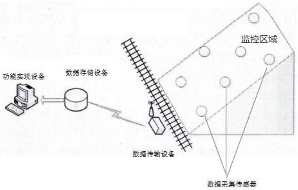
[0032] figure 1 A structural schematic diagram of a road slope monitoring system provided in an embodiment of the present invention, as figure 1 As shown, the system includes: several current data acquisition sensors, data transmission equipment and data storage equipment arranged on the slope to be detected, wherein,

[0033] The current data acquisition sensor array is set on...


PUM


Abstract

An embodiment of the present invention provides a road slope monitoring system. The system includes: several current data acquisition sensors, data transmission equipment, and data storage equipment arranged on the slope to be detected, wherein the current data acquisition sensors The array is set on the slope to be detected; the current data acquisition sensor is pre-stored with its own standard coordinates; the current data acquisition sensor obtains its own current coordinates, compares the difference between the current coordinates and the standard coordinates, and when the difference is less than When the first preset threshold is reached, the judgment result of self-coordinate change is issued; the data transmission device is used to receive the judgment result of whether the self-coordinate has changed sent by the current data acquisition sensor; the data storage device is used to store the judgment result. By applying the embodiment of the present invention, the data transmission load of the wireless sensor can be further reduced.

Description

technical field [0001] The invention relates to mountain disaster monitoring, in particular to a road slope monitoring system. Background technique [0002] Landslides seriously threaten the safety of people's lives and properties. How to give early warning to landslides is a technical problem that needs to be solved urgently. [0003] At present, wireless technology is usually used to monitor the mountain. The method is: set several wireless sensors at preset positions on the mountain, use wireless sensors to detect various technical parameters related to landslides of the mountain, and collect the collected parameters. Send it wirelessly to the data receiving device. Then, through data interpretation by special analysis software or professional analysts, whether there is a potential landslide risk in the mountain, and if there is a potential landslide risk in the mountain, an early warning will be issued. [0004] However, the inventor found in the research that there ar...

Claims


Application Information

Patent Timeline
Patent Type & Authority Patents(China)
IPC IPC(8): G01C15/00G01C1/00G01S19/14G08B21/10G08B31/00
CPCG01C1/00G01C15/00G01S19/14G08B21/10G08B31/00
Inventor 吴承照徐政戚博闻张娜潘金瓶
Owner TONGJI UNIV
Learn More