Unmanned aerial vehicle ground-imitating flight device based on laser radar

A laser radar and flying device technology, applied in the field of UAV surveying and mapping, can solve the problems of keeping the laser beam vertical to the ground and affecting the measurement accuracy, and achieve the effects of excellent impact resistance, guaranteed measurement accuracy, and strong practicability

Pending Publication Date: 2020-11-03
HENAN POLYTECHNIC UNIV
View PDF9 Cites 7 Cited by
  • Summary
  • Abstract
  • Description
  • Claims
  • Application Information

AI Technical Summary

Problems solved by technology

[0005] The purpose of the present invention is to overcome the problem that the laser beam of the existing unmanned aerial vehicle lidar system cannot keep perpendicular to the ground at all times during flight, which ...

Method used


Image

  • Unmanned aerial vehicle ground-imitating flight device based on laser radar
  • Unmanned aerial vehicle ground-imitating flight device based on laser radar
  • Unmanned aerial vehicle ground-imitating flight device based on laser radar

Examples


Embodiment 1

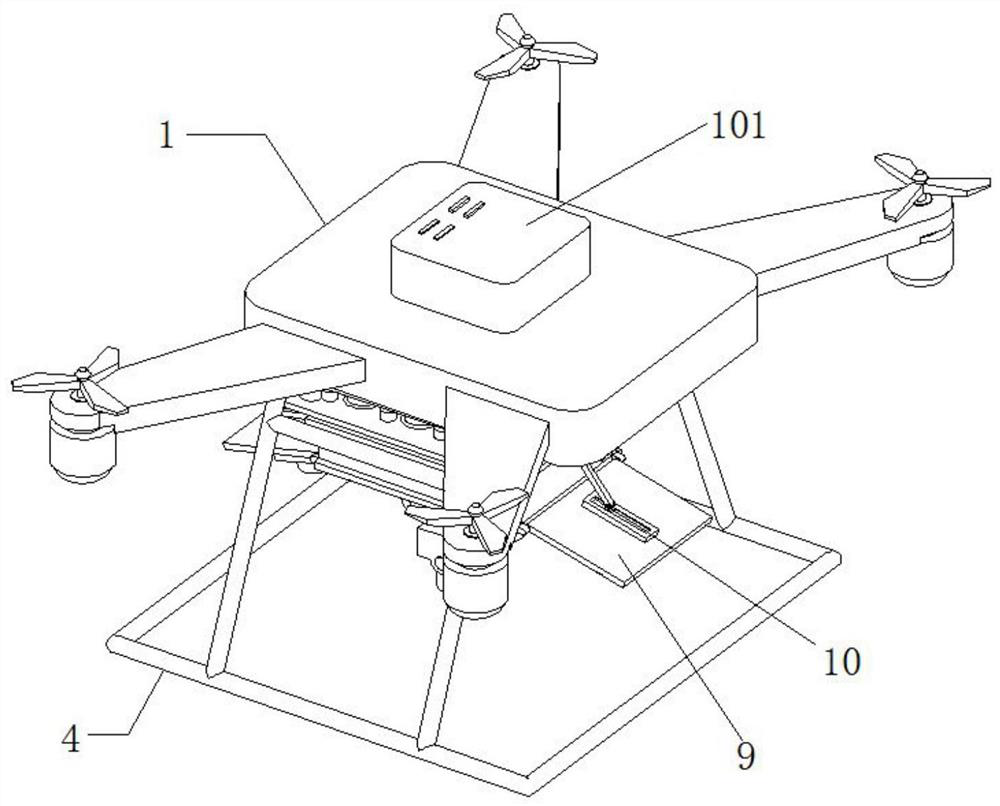
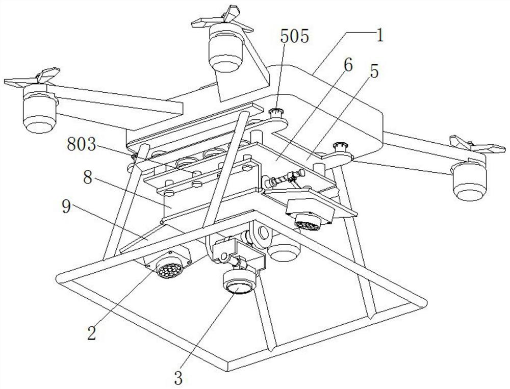
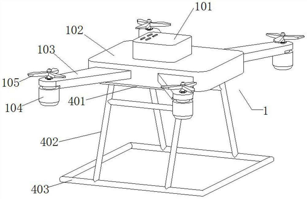
[0033] Embodiment 1 introduces a kind of UAV ground imitation flight device based on lidar, refer to the attached figure 1 , attached figure 2 And attached image 3 , which includes a drone body 1, a high-definition camera 2 and a laser radar 3. Specifically, its UAV body 1 includes a fuselage 102 and four wings 103, the four wings 103 are symmetrically connected to the fuselage 102, and the lower surface of the outer end of each wing 103 is connected with a micro motor 104, the output shaft of the micro-motor 104 protrudes from the upper end of the wing 103 and is connected with a propeller 105, and a control module 101 is arranged on the upper surface of the drone body 1, and the control of the micro-motor 104 by the control module 101 can realize unmanned Lifting, falling and horizontal operation of the machine. In addition, its laser radar 3 includes a transmitting unit, a receiving unit and an information processing module, wherein the transmitting unit, the receiving...

Embodiment 2

[0039] Embodiment 2 is a further improvement made on the basis of Embodiment 1, below in conjunction with the attached Figure 1-8 explain it further.

[0040] Embodiment 2 discloses an improved laser radar-based UAV ground imitation flight device based on Embodiment 1. Refer to the attached figure 1 , attached figure 2 And attached image 3 , which includes a drone body 1, a high-definition camera 2 and a laser radar 3. Specifically, its UAV body 1 includes a fuselage 102 and four wings 103, the four wings 103 are symmetrically connected to the fuselage 102, and the lower surface of the outer end of each wing 103 is connected with a micro motor 104, the output shaft of the micro-motor 104 protrudes from the upper end of the wing 103 and is connected with a propeller 105, and a control module 101 is arranged on the upper surface of the drone body 1, and the control of the micro-motor 104 by the control module 101 can realize unmanned Lifting, falling and horizontal operat...


PUM


Abstract

The invention relates to the technical field of unmanned aerial vehicle surveying and mapping, and particularly discloses an unmanned aerial vehicle ground-imitating flight device based on a laser radar. The unmanned aerial vehicle comprises an unmanned aerial vehicle body, a high-definition camera and a laser radar, a control module is arranged on the upper surface of the unmanned aerial vehiclebody, a landing frame is connected to the lower surface of the unmanned aerial vehicle body, an upper connecting plate is connected to the lower surface of the unmanned aerial vehicle body in the middle of the landing frame, multiple round holes are evenly formed in the upper surface of the upper connecting plate, and sliding rods are inserted into the round holes; according to the unmanned aerialvehicle ground-imitating flight device based on the laser radar, the flight height of the unmanned aerial vehicle can be detected in a high-precision mode at any time through the laser radar, and then the flight height of the unmanned aerial vehicle is adjusted in real time through the control module, so that the high-definition camera of the unmanned aerial vehicle keeps a stable height with theterrain surface during surveying and mapping; Therefore, the fixed overlapping degree of the photos is ensured, and the aerial photogrammetry precision is ensured; compared with an existing unmannedaerial vehicle surveying and mapping device, thethe unmanned aerial vehicle ground-imitating flight device is better in surveying and mapping effect.

Description

technical field [0001] The invention relates to the technical field of unmanned aerial vehicle surveying and mapping, and specifically discloses a ground imitation flight device for an unmanned aerial vehicle based on laser radar. Background technique [0002] According to the application field, UAV can be divided into military and civilian. In terms of military use, UAVs are divided into reconnaissance aircraft and target aircraft. In terms of civilian use, it is currently used in aerial photography, agriculture, plant protection, Selfie, express delivery, disaster relief, observation of wild animals, monitoring of infectious diseases, surveying and mapping, news reports, power inspections, disaster relief, film and television shooting, and romance. It expands the use of the drone itself. [0003] As an improvement of traditional aerospace remote sensing means, UAV mapping technology has become a research hotspot. In the process of UAV surveying and mapping, it is necessa...

Claims


Application Information

Patent Timeline
IPC IPC(8): G05D1/10
CPCG05D1/101
Inventor 都伟冰王双亭王蔚王涵成晓倩张合兵许琳娟李长春杨磊库
Owner HENAN POLYTECHNIC UNIV
Why Eureka
Try Eureka