Greenhouse gas emission analysis method and system based on satellite remote sensing data

A satellite remote sensing data and greenhouse gas technology, applied in the fields of analysis materials, data processing applications, climate sustainability, etc., can solve inaccurate model estimation, high spatial resolution emission inventory inversion error, and affect the accuracy of emission level analysis Issues such as the visualization effect of the permanent emission inventory, to achieve the effect of improving the superiority and precision, improving the spatial resolution, and improving the accuracy and accuracy

Active Publication Date: 2020-11-06
TIANJIN NORMAL UNIVERSITY
View PDF16 Cites 7 Cited by
  • Summary
  • Abstract
  • Description
  • Claims
  • Application Information

AI Technical Summary

Problems solved by technology

However, due to the spatiotemporal heterogeneity of the emission levels of greenhouse gases and atmospheric pollutants, the traditional least squares method or panel data regression model is based on the "temporal and spatial homogeneity assumption", ignoring the differences between spatial units. Spatial effects will cause inaccurate model estimation, and there will be large errors in the inversion of emission inventories with high spatial resolution using traditional methods
Furthermore, because the traditional analysis methods are all based on the "tempo...

Method used


Image

  • Greenhouse gas emission analysis method and system based on satellite remote sensing data
  • Greenhouse gas emission analysis method and system based on satellite remote sensing data
  • Greenhouse gas emission analysis method and system based on satellite remote sensing data

Examples


Embodiment Construction

[0044] In order to make the object, technical solution and advantages of the present invention more clear, the present invention will be further described in detail below in conjunction with the examples. It should be understood that the specific examples described here are only used to explain the present invention, not to limit the present invention.

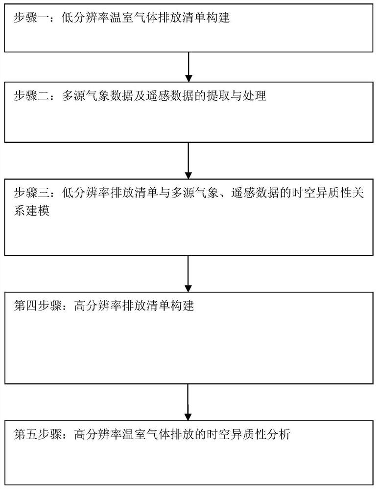
[0045] see figure 1 , the present invention provides a greenhouse gas emission analysis method based on satellite remote sensing data, comprising the following steps:

[0046] Step 1. Construction of low-resolution emission inventory:

[0047] Low-resolution emission inventory refers to the corresponding high-level emission inventory, which has a lower spatial resolution and usually takes administrative boundaries such as provinces / prefecture-level cities / autonomous regions / municipalities as spatial units, and may even be lower spatial scales, such as national standard emissions inventory. That is, the low-resolution emissi...


PUM


Abstract

The invention provides a greenhouse gas emission analysis method and system based on satellite remote sensing data, and the method comprises the steps: building a low-resolution emission list which comprises the greenhouse gas emissions of a plurality of low-resolution geographic space units in different time periods; extracting and processing multi-source meteorological data and remote sensing data; modeling the space-time heterogeneity relationship between the low-resolution emission list and the multi-source weather and remote sensing data, namely, correspondingly forming a fitting data setaccording to the low-resolution emission list by taking a plurality of weather factor variables and night light numerical values of each space-time position as space distribution factors, and modeling at each space-time position; and then carrying out high-resolution emission list construction and emission list space-time heterogeneity evolution rule analysis. According to the method, the spatialresolution of the emission list is improved, meanwhile, the goodness and precision of greenhouse gas emission list simulation and space distribution are effectively improved, and the greenhouse gas emission level and the space-time evolution rule of the greenhouse gas emission level are truly reflected.

Description

technical field [0001] The invention belongs to the technical field of inversion monitoring of greenhouse gas emissions, and in particular relates to a method and system for analyzing greenhouse gas emissions based on satellite remote sensing data. Background technique [0002] High-resolution greenhouse gas emission inventory downscaling technology refers to improving the spatial resolution of greenhouse gas and air pollutant emissions directly or indirectly emitted in production activities, that is, low-resolution emission inventory downscaling technology, by converting low-resolution The technique of assigning the emission inventory space to a regular grid scale can provide a more refined and gridded greenhouse gas emission inventory. Among them, the low-resolution emission inventory usually refers to the total amount of greenhouse gas emissions within administrative boundaries such as provinces / cities / autonomous regions / municipalities. The high-resolution emission inven...

Claims


Application Information

Patent Timeline
IPC IPC(8): G01N33/00G06Q50/26G06Q10/06
CPCG01N33/0062G06Q50/26G06Q10/0639Y02P90/84
Inventor 张为师汪炯骅徐颖王灿
Owner TIANJIN NORMAL UNIVERSITY
Why Eureka
Try Eureka