
Geological disaster multi-modal monitoring data fusion imaging method based on resistivity method

A resistivity method and geological disaster technology, applied in the field of multi-modal monitoring data fusion imaging of geological disasters based on the resistivity method, can solve the problem that the macroscopic surface displacement monitoring data cannot effectively reflect the deformation process of geological bodies and cannot be fully described in space and explain the overall deformation and evolution mechanism of 3D geological bodies, so as to improve the accuracy and accuracy of clustering, improve the effectiveness, and accurately collect

Inactive Publication Date: 2020-11-24
EAST CHINA UNIV OF TECH
View PDF12 Cites 2 Cited by
  • Summary
  • Abstract
  • Description
  • Claims
  • Application Information

AI Technical Summary

Problems solved by technology

[0004] The purpose of the present invention is to solve the problem that in the research process of landslide deformation evolution mechanism, the macroscopic surface displacement monitoring data cannot effectively reflect the internal deformation process of the geological body, and the deep displacement and related monitoring are limited by technical conditions such as drilling, and cannot be fully described and explained in space. In order to solve the problem of the evolution mechanism of the overall deformation of 3D geological bodies, a method based on the resistivity method for multi-modal monitoring data fusion imaging of geological disasters is provided.

Method used


Image

  • Geological disaster multi-modal monitoring data fusion imaging method based on resistivity method
  • Geological disaster multi-modal monitoring data fusion imaging method based on resistivity method
  • Geological disaster multi-modal monitoring data fusion imaging method based on resistivity method

Examples


Embodiment 1

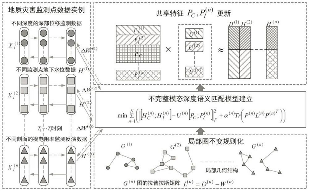
[0037]Embodiment 1: A multi-modal monitoring data fusion imaging method for geological disasters based on the resistivity method, with the resistivity monitoring data as a complete modal subspace to include the spatial and temporal discontinuity of water level, deep displacement and soil moisture The data method is an incomplete modal data set, and the geometric structure of the data is encoded by the graph regularization factor to ensure the local similarity of each modal data; the fusion of deep learning and incomplete multi-modal analysis is used to construct a fusion modal deep neural network And the deep semantic matching model of incomplete multimodal matrix decomposition, through the joint deep matrix decomposition, optimization, and layer-by-layer modal semantic matching and updating, the deep semantic matching features of multimodal data are obtained. Complete multimodal data includes at least the analysis of classification and clustering, including the following:

[...


PUM


Abstract

The invention relates to a geological disaster multi-modal monitoring data fusion imaging method based on a resistivity method. The method is characterized in that resistivity monitoring data is usedas a complete modal subspace, a spatial and temporal discontinuous data mode including water level, deep displacement and soil humidity is used as an incomplete modal data set, and a geometric structure of the data is coded through a graph regularization factor to ensure the local similarity of each modal data; deep learning and incomplete multi-modal analysis are fused to construct a deep semantic matching model fusing a modal deep neural network and incomplete multi-modal matrix decomposition; the deep semantic matching characteristics of the multi-modal data are obtained by combining deep matrix decomposition, optimization and layer-by-layer modal semantic matching and updating, and the incomplete multi-modal data in the shared space at least comprises classification and clustering analysis. The effectiveness of a dynamic change inversion section of a landslide seepage field, a geologic body structure field and a deep displacement field generated by coupling is improved.

Description

technical field [0001] The invention relates to a geological disaster monitoring data fusion imaging method, in particular to a geological disaster multi-modal monitoring data fusion imaging method based on a resistivity method. Background technique [0002] Geological hazards are complex physical systems with a long-term evolution process. From the perspective of evolution mechanism, the landslide is the result of the joint action of the basic field, action field and coupling field produced by the geological structure field, seepage field, stress field, chemical field and temperature field. The monitoring of landslide evolution process includes: deformation monitoring, influencing factor monitoring and macroscopic precursor monitoring. Currently, synthetic aperture radar (InSAR), three-dimensional laser scanning, and geographic information system (GIS) technologies are mainly used for macroscopic deformation monitoring in large landslide areas. The key monitoring of hidde...

Claims


Application Information

Patent Timeline
IPC IPC(8): G01V3/00G01N27/04G06K9/62
CPCG01V3/00G01N27/041G06F18/23G06F18/24
Inventor 徐哈宁肖慧邓居智简语黄灵湛刘奇王泽辉李熠钊孙蒙侯洁婷
Owner EAST CHINA UNIV OF TECH
Learn More