Indoor substation unmanned aerial vehicle visual navigation system and method

A visual navigation and unmanned aerial vehicle technology, applied in the field of substation inspection, can solve the problems of large amount of calculation, difficult processor processing, unable to complete inspection, etc., and achieve the effect of reducing the amount of calculation

Pending Publication Date: 2020-12-08
STATE GRID INTELLIGENCE TECH CO LTD
View PDF10 Cites 0 Cited by
  • Summary
  • Abstract
  • Description
  • Claims
  • Application Information

AI Technical Summary

Problems solved by technology

[0004] However, according to the inventor’s knowledge, if the traditional visual SLAM technology is applied to UAV substation inspection, there will be the following problems: 1) The step of closed-loop detection is very critical, but the reliability is not good, and the success rate of closed-loop detection is not 100%. %, once the closed-loop detection cannot be performed, the accumulation of positioning errors cannot be corrected, and the drone will fail to locate, and the

Method used


Image

  • Indoor substation unmanned aerial vehicle visual navigation system and method
  • Indoor substation unmanned aerial vehicle visual navigation system and method
  • Indoor substation unmanned aerial vehicle visual navigation system and method

Examples


Embodiment 1

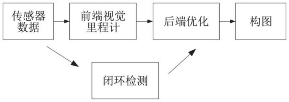
[0051] This embodiment discloses a visual navigation system for an indoor substation UAV, such as Figure 5 As shown in the figure, it includes: the forward binocular perception module and the downward binocular perception module mounted on the unmanned aerial vehicle, both of which are connected to the flight control terminal of the unmanned aerial vehicle. In addition, it also includes a set of pre-installed inspection positions in the substation. of multiple identification codes.

[0052] The plurality of identification codes are arranged at positions to be inspected in the substation to identify each position to be inspected, and do not need to be arranged on the inspection route, and the plurality of identification codes have different identification information. In this embodiment, a plurality of identification codes are respectively arranged on the wall near the position to be inspected, and the identification code adopts the ARTag identification code, and the identific...

Embodiment 2

[0079]Based on the navigation system provided in the first embodiment, this embodiment provides a navigation method applied to an indoor substation. Specifically, an identification code is pre-arranged at each position to be inspected. In this embodiment, the identification code of each position is an ARTag identification code with a different ID, and the three-dimensional space information of the indoor substation and the coordinate information of each identification code are stored; The method specifically includes the following steps:

[0080] Step 1: Obtain an inspection task, the inspection task includes a plurality of positions to be inspected, start the inspection, control the drone to take off, hover and inspect at the first inspection position;

[0081] Step 2: After the inspection of the first inspection position is completed, the image of the inspection position is acquired through the forward visual perception module, and the corresponding identification code of th...


PUM


Abstract

The invention discloses an indoor substation unmanned aerial vehicle visual navigation system and method. The system comprises a forward binocular perception module and a downward binocular perceptionmodule which are connected with an unmanned aerial vehicle flight control end. The flight control terminal comprises: a path planning unit configured to obtain a binocular image in real time throughan unmanned aerial vehicle forward visual perception module in the flight process of the unmanned aerial vehicle, construct a depth map, and perform path planning based on the depth map; and a visualodometer unit which is configured to acquire an image in real time through the downward visual perception module and calculate the current mileage of the unmanned aerial vehicle in the flight processof the unmanned aerial vehicle. Obstacle avoidance and path planning can be achieved only through a local map, and the operand is greatly reduced; and through multiple identification codes, accumulated errors in the unmanned aerial vehicle positioning process can be conveniently corrected in time.

Description

technical field [0001] The invention belongs to the technical field of substation inspection, and in particular relates to a visual navigation system and method for an indoor substation unmanned aerial vehicle. Background technique [0002] The statements in this section merely provide background information related to the present disclosure and do not necessarily constitute prior art. [0003] SLAM technology is a technology that is used for indoor navigation and simultaneous positioning and map construction. It was first applied in the field of robotics. Its goal is to build a map of the surrounding environment in real time based on sensor data without any prior knowledge This map infers its own location. SLAM that only utilizes cameras as external perception sensors is called visual SLAM. The camera has the advantages of rich visual information and low hardware cost. The classic visual SLAM system generally includes front-end visual odometry, back-end optimization, clos...

Claims


Application Information

Patent Timeline
IPC IPC(8): G01C21/20
CPCG01C21/206
Inventor 刘天立刘越李豹赵金龙刘俍吕俊涛王安山刘丙伟王人杰孙晓斌黄振宁张飞高绍楠
Owner STATE GRID INTELLIGENCE TECH CO LTD
Why Eureka
Try Eureka