Remote sensing ecological environment quality evaluation method and device and electronic equipment
A technology of environmental quality and remote sensing, applied in image data processing, complex mathematical operations, instruments, etc., can solve problems such as poor evaluation accuracy, achieve high accuracy, alleviate poor evaluation accuracy, and comprehensive data
- Summary
- Abstract
- Description
- Claims
- Application Information
AI Technical Summary
Problems solved by technology
Method used
Image
Examples
Embodiment 1
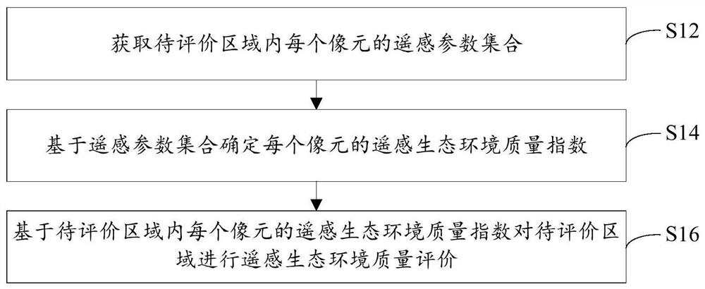
[0027] figure 1 A flow chart of a remote sensing ecological environment quality evaluation method provided by the embodiment of the present invention, such as figure 1 As shown, the method includes the following steps:
[0028] Step S12, obtaining the set of remote sensing parameters of each pixel in the area to be evaluated.
[0029] In the embodiment of the present invention, in order to obtain more accurate remote sensing ecological environment quality evaluation results, when evaluating the ecological environment quality of the area to be evaluated, first obtain the remote sensing parameter set of each pixel in the area to be evaluated, wherein the remote sensing parameter set Included are: Land Use Type Index, Normalized Difference Vegetation Index, Net Primary Productivity, Enhanced Vegetation Index, Atmospheric Precipitable Water, Surface Temperature, Vertical Drought Index, Normalized Difference Building Index, Atmospheric Aerosol Optical Depth, Pollutant Gas Concentr...
Embodiment 2
[0080] The embodiment of the present invention also provides a remote sensing ecological environment quality evaluation device. The remote sensing ecological environment quality evaluation device is mainly used to implement the remote sensing ecological environment quality evaluation method provided in the first embodiment above. The environmental quality assessment device will be introduced in detail.
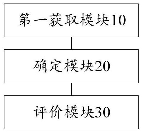
[0081] image 3 It is a functional block diagram of a remote sensing ecological environment quality evaluation device provided by the embodiment of the present invention, as image 3 As shown, the device mainly includes: a first acquisition module 10, a determination module 20, and an evaluation module 30, wherein:
[0082] The first acquisition module 10 is used to acquire the remote sensing parameter set of each pixel in the area to be evaluated, wherein the remote sensing parameter set includes: land use type index, normalized difference vegetation index, net primary produ...
Embodiment 3
[0107] see Figure 4 , the embodiment of the present invention provides an electronic device, the electronic device includes: a processor 60, a memory 61, a bus 62 and a communication interface 63, the processor 60, the communication interface 63 and the memory 61 are connected through the bus 62; the processor 60 is used to execute executable modules, such as computer programs, stored in memory 61 .
[0108] Wherein, the memory 61 may include a high-speed random access memory (RAM, RandomAccessMemory), and may also include a non-volatile memory (non-volatile memory), such as at least one disk memory. The communication connection between the system network element and at least one other network element is realized through at least one communication interface 63 (which may be wired or wireless), and the Internet, wide area network, local network, metropolitan area network, etc. can be used.
[0109] The bus 62 can be an ISA bus, a PCI bus or an EISA bus, etc. The bus can be d...
PUM
 Abstract
Description
Claims
Application Information
 - R&D
- Intellectual Property
- Life Sciences
- Materials
- Tech Scout
- Unparalleled Data Quality
- Higher Quality Content
- 60% Fewer Hallucinations
Browse by: Latest US Patents, China's latest patents, Technical Efficacy Thesaurus, Application Domain, Technology Topic, Popular Technical Reports.
© 2025 PatSnap. All rights reserved.Legal|Privacy policy|Modern Slavery Act Transparency Statement|Sitemap|About US| Contact US: help@patsnap.com


