Fusion positioning tracking control method based on multi-source image adaptive weight selection

A technology of tracking control and fusion positioning, which is applied in three-dimensional position/channel control, vehicle position/route/altitude control, attitude control, etc., and can solve problems such as signal attenuation and the influence of positioning and tracking accuracy
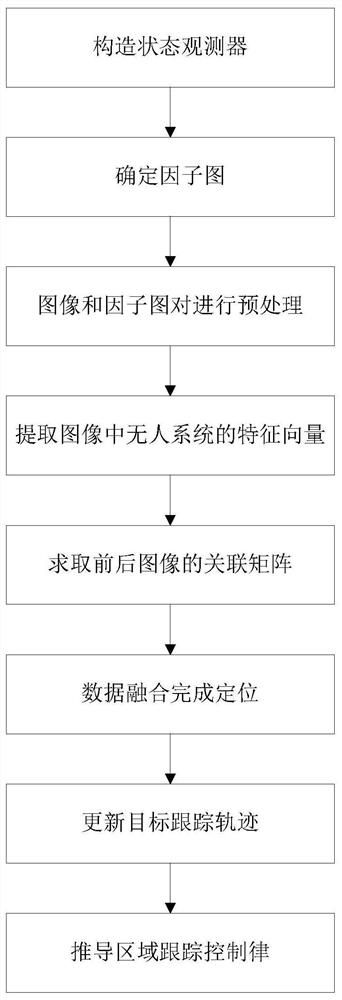
Active Publication Date: 2021-03-12
青岛民航凯亚系统集成有限公司
View PDF8 Cites 1 Cited by
  • Summary
  • Abstract
  • Description
  • Claims
  • Application Information

AI Technical Summary

Problems solved by technology

The satellite navigation system also has typical defects. During the positioning process, the unmanned system has requirements for the number of satellites and signa...

Method used


Image

  • Fusion positioning tracking control method based on multi-source image adaptive weight selection
  • Fusion positioning tracking control method based on multi-source image adaptive weight selection
  • Fusion positioning tracking control method based on multi-source image adaptive weight selection

Examples


Embodiment 1

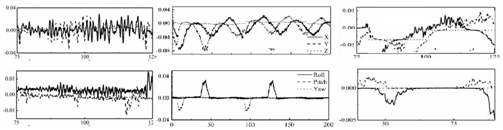
[0261] In order to verify the patented method of the present invention, a comparative simulation verification experiment is designed:

[0262] Under the same area tracking control, the conventional high-gain observer and state observer are used for comparative simulation verification;

[0263] Under the same state observer, the traditional inversion control method is used for comparative simulation verification.

[0264] During the verification process of the simulation experiment, the initial state and external disturbance of the unmanned system are all the same. ,

[0265] The comparison results obtained by using the Matlab / Simulink simulation platform are as follows: figure 2 shown. The first column is position information, the second column is attitude information, and the third column is control rate information.

[0266] From the speed estimation results, both the state observer and the high-gain observer in the patent of the present invention can obtain better spee...

Embodiment 2

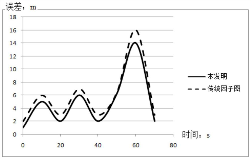
[0268] The present invention uses the KITTI data set for experimental verification.

[0269] The experiment uses the KITTI data set collected under the real road conditions of the unmanned vehicle to conduct the experiment, selects two sections of the path, and sets the satellite signal loss of three time periods in a total of 80 seconds, from the 10th to the 15th second. The 5-second interval, the 10-second interval from the 25th second to the 35th second, and the 20-second interval from the 45th second to the 65th second, each with a 10-second interval in between to observe the recovery of the error when the satellite signal can be received normally. The statistical results of the error comparing this method with the traditional method are shown in Table 1:

[0270] Table 1

[0271] Experimental results The method of this paper Traditional factor graph Average value / m 3.94 4.49 max / m 14.84 17.04 RMSE / m 4.59 5.02

[0272] It can be see...

Embodiment 3

[0274] Embodiments of the present invention are given in conjunction with specific numerical values:

[0275] Dataset Preparation Phase

[0276] In order to make the data set closer to the real environment, and to better test and compare and analyze the present invention, an infrared-visible light tracking data set is constructed from a large number of original UAV video data sets.

[0277] 22 pairs of video segments suitable for multi-target tracking were carefully selected from the original dataset, and a total of 22 pairs of image sequences were generated after a series of image preprocessing such as cropping and registration. The dataset covers a wide range of working environments, such as foggy days, frequent illumination changes, far small targets, and multi-scale environments. It can well train the tracking network and test the generalization ability and performance of the network. The data sets are the environment of far and small objects near the sky; the multi-scale...


PUM


Abstract

The invention belongs to the technical field of artificial intelligence navigation and positioning, and particularly relates to a fusion positioning tracking control method based on multi-source imageadaptive weight selection. The method comprises the following steps: constructing a state observer according to an unmanned system kinetic model, a linear transformation state quantity and a pose information nonlinear term; detecting a target in each frame of image of a GPS or Beidou system video, selecting one frame of image as detection input, outputting a group of bounding boxes for the unmanned system of the image, and calculating the central position of the target in the image; and determining an expression and an initial node of the factor graph according to the initial position determined by GPS or Beidou system positioning, and the like. The state observer is constructed by combining state variable linear conversion and the kinetic model; and a region tracking control law is designed by utilizing nonlinear conversion mapping of tracking errors, so that the tracking errors are not converged to zero, control signals are gentler, and driving of an unmanned system under the actualcondition is more facilitated.

Description

technical field [0001] The invention belongs to the technical field of artificial intelligence navigation and positioning, in particular to a fusion positioning and tracking control method based on multi-source image adaptive weight selection. Background technique [0002] With the development of artificial intelligence technology, the research and development of drones and unmanned vehicles are changing with each passing day. Among them, for the unmanned control system, solving the positioning problem is the basic guarantee for realizing the overall function. The positioning accuracy is closely related to the driving safety and work efficiency of the unmanned control system. Simply relying on sensors to complete the positioning function can no longer meet the requirements for positioning accuracy. In addition, multi-system fusion automatic tracking can effectively avoid monitoring errors caused by human factors, and provide a basis for analyzing and judging the driving beh...

Claims


Application Information

Patent Timeline
IPC IPC(8): G05D1/08G05D1/10
CPCG05D1/0808G05D1/101
Inventor 不公告发明人
Owner 青岛民航凯亚系统集成有限公司
Why Eureka
Try Eureka