Oil field inspection unmanned aerial vehicle scheduling method and system and computer medium

A scheduling method and technology of unmanned aerial vehicles, applied in the directions of calculation, inspection time patrol, instruments, etc., can solve the problems of inability to conduct monitoring and scheduling on a large scale, limited processing capacity of unmanned aerial vehicles for oilfield inspection, and low work efficiency. Improve the accuracy of inspection, save time and improve work efficiency

Pending Publication Date: 2021-03-30
北京大学(天津滨海)新一代信息技术研究院
View PDF3 Cites 6 Cited by
  • Summary
  • Abstract
  • Description
  • Claims
  • Application Information

AI Technical Summary

Problems solved by technology

[0005] The present invention proposes a scheduling method, system and computer medium for oilfield inspection drones, aiming to solve the problems of limited processing capacity of existing oilfield inspection drones, inability to monitor and dispatch on a large scale, and low work efficiency

Method used


Image

  • Oil field inspection unmanned aerial vehicle scheduling method and system and computer medium
  • Oil field inspection unmanned aerial vehicle scheduling method and system and computer medium
  • Oil field inspection unmanned aerial vehicle scheduling method and system and computer medium

Examples


Embodiment 1

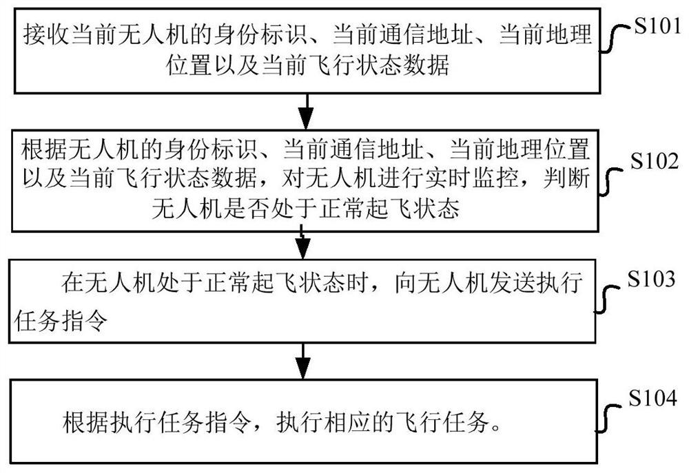
[0047] figure 1 A schematic diagram of the steps of the scheduling method for the oil field inspection UAV according to the embodiment of the present application is shown in .

[0048] like figure 1 As shown, the scheduling method of the oil field inspection UAV in the embodiment of the present application specifically includes the following steps:

[0049]S101: Receive the current drone's identity, current communication address, current geographic location and current flight status data.

[0050] First, the oilfield inspection UAV sends its own identity ID (ID entity), current communication address IP, current geographic location (longitude, latitude, altitude) and flight status data to the server.

[0051] The corresponding oil field inspection UAV includes a flight control module, a communication module and a GPS positioning module. The identity ID is stored in the flight control module, and the current communication IP address is stored in the communication module. The...

other Embodiment approach

[0064] In other embodiments, the real-time monitoring of the UAV also includes:

[0065] Real-time monitoring of the current geographic location of the UAV. When the current geographic location of the UAV is in the early warning geographic location, such as some sensitive areas where flying is prohibited, an early warning message is sent to the UAV.

[0066] Realized flight restrictions on certain sensitive areas, the server can establish a sensitive area database, and trigger an alarm when the route of the oil field inspection drone passes or the oil field inspection drone approaches these areas. At this time, the algorithm of point-to-point distance and point-to-line distance in geometric mathematics is used, and according to the constants such as the radius of the earth, the distance value in meters can be converted.

[0067] Further, to judge whether the UAV is in a normal take-off state, the judgment process is as follows:

[0068] S1: Pre-set the task data table, which ...

Embodiment 2

[0120] This embodiment provides a scheduling system for oilfield inspection drones. For details not disclosed in the oilfield inspection drone scheduling system in this embodiment, please refer to the scheduling method for oilfield inspection drones in other embodiments specific implementation content.

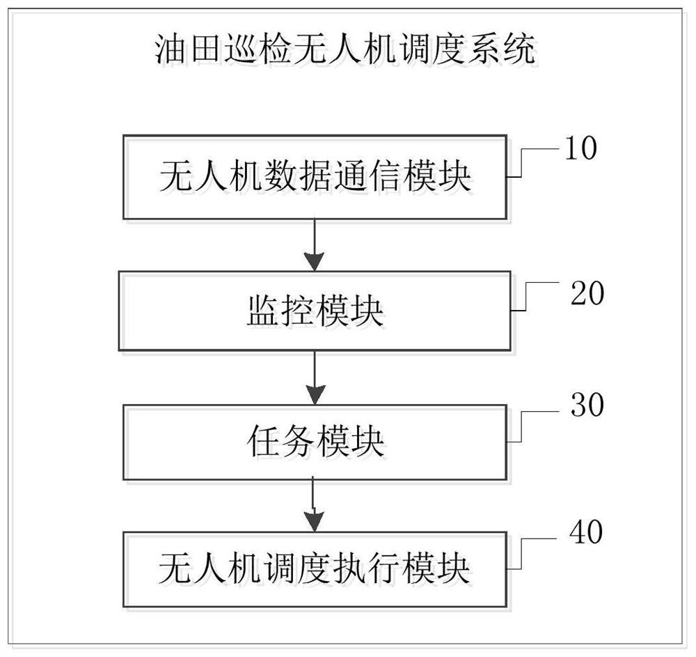
[0121] figure 2 A schematic structural diagram of an oilfield inspection UAV scheduling system according to an embodiment of the present application is shown in .

[0122] like figure 2 As shown, the UAV scheduling system for oil field inspection in the embodiment of the present application specifically includes a UAV data communication module 10 , a monitoring module 20 , a task module 30 and a UAV scheduling execution module 40 .

[0123] UAV data communication module 10: for receiving the UAV's identity, current communication address, current geographic location and current flight status data.

[0124] First, the oilfield inspection UAV sends its own identity ID (ID en...


PUM


Abstract

The embodiment of the invention provides an oil field inspection unmanned aerial vehicle scheduling method and system and a computer medium. The method comprises the steps of receiving an identity identifier, a current communication address, a current geographic position and current flight state data of a current unmanned aerial vehicle; monitoring the unmanned aerial vehicle in real time according to the identity label, the current communication address, the current geographic position and the current flight state data of the unmanned aerial vehicle, and judging whether the unmanned aerial vehicle is in a normal take-off state or not; when the unmanned aerial vehicle is in a normal take-off state, sending a task execution instruction to the unmanned aerial vehicle; and executing a corresponding flight task according to the task execution instruction. According to the invention, a plurality of oil field inspection unmanned aerial vehicles can be dispatched and controlled at the same time, cooperation among the plurality of oil field inspection unmanned aerial vehicles is realized, inspection tasks can be completed rapidly, time is saved, and working efficiency and inspection accuracy are improved.

Description

technical field [0001] The present application belongs to the technical field of image classification, and in particular relates to a scheduling method, system and computer medium of an oil field inspection drone. Background technique [0002] At present, the total mileage of my country's oil and gas pipelines is nearly 150,000 kilometers, and the oil and gas pipelines spanning thousands of miles provide important energy for the national economy and the daily life of residents. In order to ensure the safety of energy transmission, they must be inspected regularly. Oilfield inspection technology has roughly experienced three development stages: manual inspection technology, semi-automatic inspection technology, and drone inspection technology. The object of manual inspection is oil production workers who have mastered certain skills and knowledge of oil wells. Oil production workers rely on walking and carrying maintenance tools to patrol and check records one by one for al...

Claims


Application Information

Patent Timeline
Patent Type & Authority Applications(China)
IPC IPC(8): G06Q10/06G07C1/20G07C5/08
CPCG06Q10/0631G07C1/20G07C5/08
Inventor 陈方平陆煜衡李蕴仪
Owner 北京大学(天津滨海)新一代信息技术研究院
Why Eureka
Try Eureka