Method for measuring tree canopy height through satellite remote sensing

A technology of canopy height and satellite remote sensing, which is applied in the field of tree canopy height measurement based on satellite remote sensing data, can solve the problems of demanding visibility conditions, increased workload, and high instrument prices, so as to reduce the amount of data calculation and data cycle Short, efficient results

Inactive Publication Date: 2021-04-30
四川天奥空天信息技术有限公司
View PDF10 Cites 9 Cited by
  • Summary
  • Abstract
  • Description
  • Claims
  • Application Information

AI Technical Summary

Problems solved by technology

When using total station measurement, the conditions of visibility are demanding, and the workload will be multiplied accordingly.
While the 3D laser scanner is widely used, there are still certain limitations, such as the high price of the instrument, mutual occlusion when used in tree scanning, etc., which limit the application in forestry
However, this method has not been reported

Method used


Image

  • Method for measuring tree canopy height through satellite remote sensing
  • Method for measuring tree canopy height through satellite remote sensing
  • Method for measuring tree canopy height through satellite remote sensing

Examples


Embodiment Construction

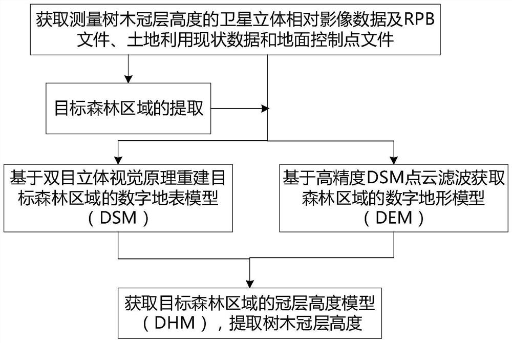
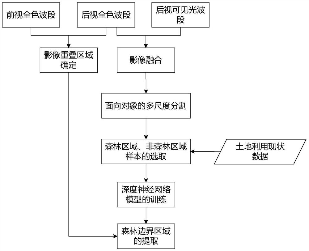
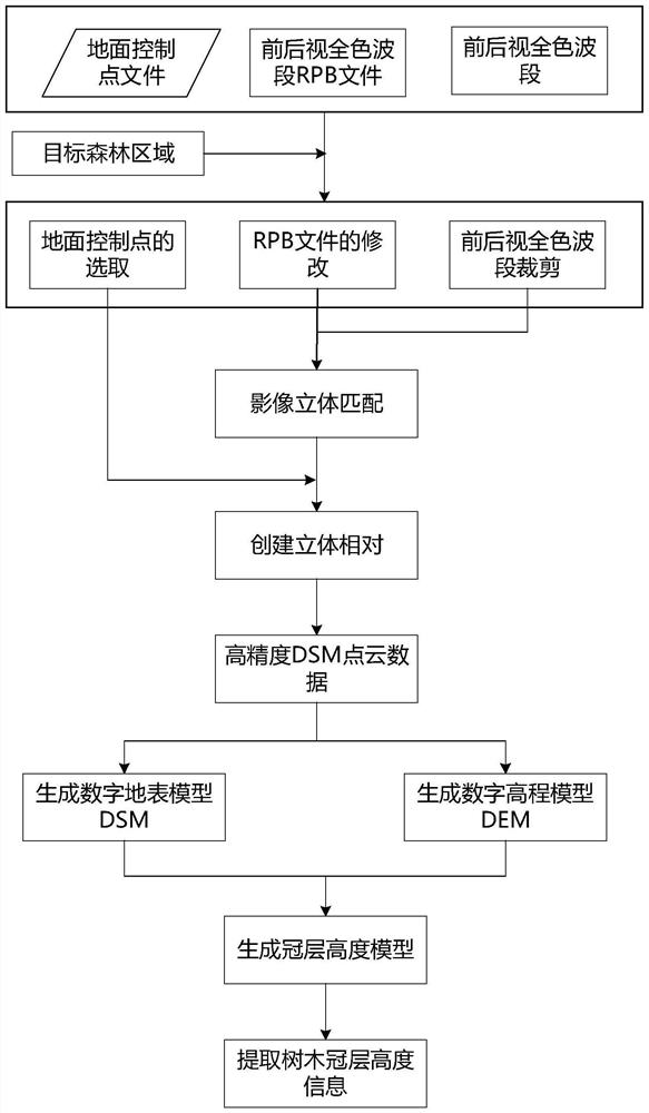
[0021] refer to figure 1 . According to the present invention, obtain the satellite stereoscopic relative image data and RPB file, land use present situation data and ground control point file for measuring tree canopy height; To the overlapping region in the satellite stereoscopic relative image data that obtains, adopt deep neural network model and The object-oriented remote sensing image classification technology extracts the target forest area in different directions; according to the target forest area extracted by superimposing the satellite stereo relative image data, RPB file and ground control point file, the satellite stereo relative image data and the corresponding RPB of the target forest area are obtained Files, ground control point files; based on the principle of binocular stereo vision, using semi-global matching algorithm (SGM) and rational function model, combined with the ground control point files in the target forest area to perform image stereo matching o...


PUM


Abstract

The invention discloses a method for measuring the tree canopy height through satellite remote sensing, wherein the method has the advantages of being wide in coverage range, short in data obtaining period and low in data obtaining cost. The method is realized through the following calculation scheme: extracting target forest regions in different directions from an overlapping region in acquired satellite three-dimensional relative image data by adopting a deep neural network model and an object-oriented remote sensing image classification technology; obtaining satellite stereo relative image data and a ground control point file of a target forest area according to the satellite stereo relative image data and the target forest area extracted by superposing an RPB file and the ground control point file; calculating canopy structure characteristic parameters of the target forest area, and generating a digital surface model DSM and a digital elevation model DEM of the target forest area; and in combination with image calculation of raster data, subtracting the obtained digital elevation model from the obtained digital surface model to obtain a canopy height DHM, and calculating the tree canopy height from a three-dimensional angle to realize measurement of the tree canopy height.

Description

technical field [0001] The invention relates to the related technical fields of satellite remote sensing forest ecology, hydrology and biophysics, and in particular to a tree canopy height measurement method based on satellite remote sensing data. Background technique [0002] Vegetation is the most important part of terrestrial ecosystems. Tree measurement plays an important role in urban construction, urban greening, hidden danger monitoring of power transmission lines, and protection of precious trees. has a major effect. The measurement of tree shape and size is an important part of tree measurement, mainly including the measurement of tree height, diameter at breast height and crown width. Tree height refers to the height difference between the highest point of the tree crown and the ground where the root of the tree is located, that is, the distance from the reference point to the reference plane where the highest point is located, that is, the height. The traditiona...

Claims


Application Information

Patent Timeline
Patent Type & Authority Applications(China)
IPC IPC(8): G01B11/03G01B11/00G06K9/62G06N3/08
CPCG01B11/03G01B11/002G06N3/08G06F18/253
Inventor 权奕铭崔肖林杨学海
Owner 四川天奥空天信息技术有限公司
Why Eureka
Try Eureka