
Air pollution prediction method based on deep fusion of multi-source space-time big data

A technology for air pollution and prediction methods, applied in structured data retrieval, electrical digital data processing, digital data information retrieval, etc., can solve problems such as coarse ground resolution, large gaps, and influence estimation results, and achieve large space-time coverage. , a wide range of time and space, the effect of comprehensive influence factors

Active Publication Date: 2021-06-04
INST OF GEOGRAPHICAL SCI & NATURAL RESOURCE RES CAS
View PDF4 Cites 11 Cited by
  • Summary
  • Abstract
  • Description
  • Claims
  • Application Information

AI Technical Summary

Problems solved by technology

Although existing technologies have used nonlinear methods to imput missing values, which are better than simple alternative methods, their missing value imputation methods are based on coarse-resolution meteorological data (resolution 25km x 25km), which is the same as the inverted Resolution of surface air pollution concentration (1x1km 2 ) is too large, which is one of the reasons for the deviation of the estimated results
[0005] Due to the lack of high-resolution important meteorological parameters (air temperature, relative humidity, wind speed and air pressure, etc.) Estimated biases in surface air pollutant concentrations
The existing technology proposes a comprehensive meteorological environment assessment method that integrates multi-source remote sensing information and climate environment. The method is based on relatively coarse satellite resolution, and only inverts and evaluates the seasonal air pollution concentration distribution, lacking high-time Resolution results
The existing technology also proposes an inversion method for satellite-ground comprehensive quantitative remote sensing fusion of atmospheric particles. and the resolution of meteorological parameters used in the inversion is relatively coarse
For the fusion of multi-source remote sensing data, based on GEOS-FP (Goddard Earth Observing System-Forward Processing) series number inversion PM 2.5 Pollutants, similarly, the ground resolution used for inversion is relatively coarse, and it is difficult to reflect the changes of the ground at a fine scale
As well as the existing deep forest algorithm to estimate the urban model estimation, this method will be limited by the input discrete data of the tree-based learning model, which will lead to surface modeling discontinuity when the number of samples is small
Although deep learning CNN has been used to reconstruct surface parameters of air pollution, due to the complex nonlinear relationship between air pollution and influencing factors, it is difficult to use convolutional networks to achieve ideal results, and too deep a network will lead to gradient The disappearance problem affects the final estimation result
The existing technology also proposes a PM based on air quality data and images to achieve multi-source heterogeneous fusion. 2.5 Prediction model, this method needs to collect photos to estimate PM 2.5 concentration, the evaluation result is affected by the ambient scattered light, and the estimation accuracy is limited

Method used


Image

  • Air pollution prediction method based on deep fusion of multi-source space-time big data
  • Air pollution prediction method based on deep fusion of multi-source space-time big data
  • Air pollution prediction method based on deep fusion of multi-source space-time big data

Examples


Embodiment Construction

[0058] The present invention will be further described in detail below in conjunction with the accompanying drawings and specific embodiments.

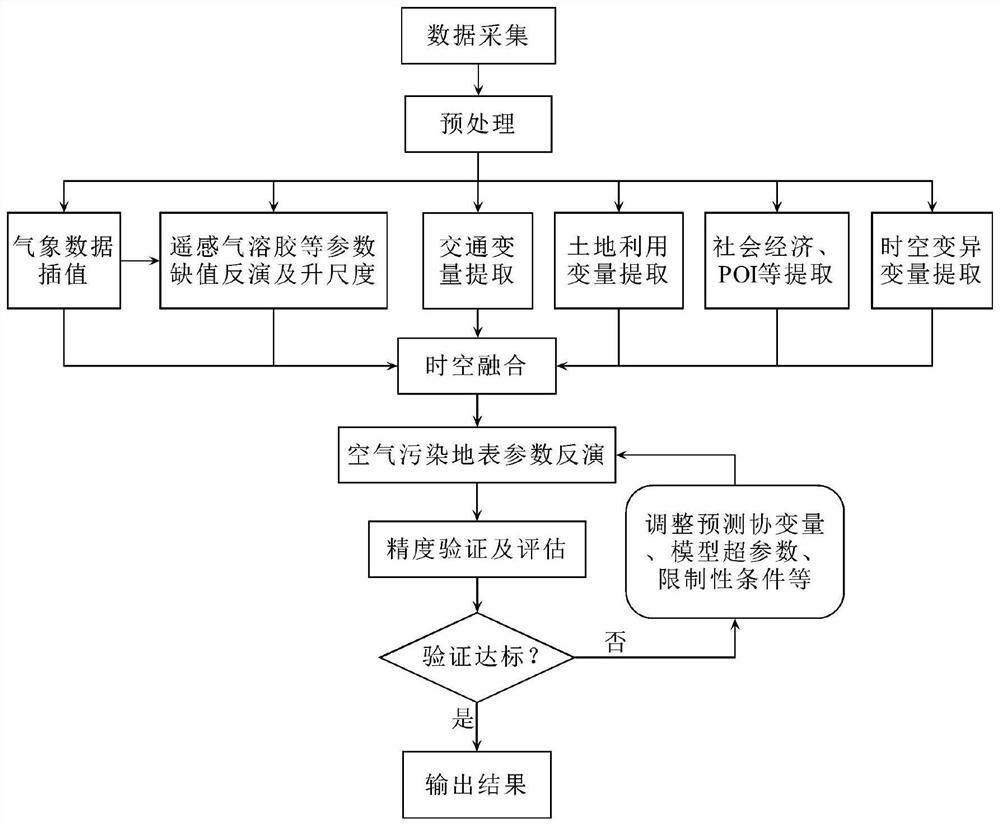
[0059] The existing spatio-temporal estimation method of air pollutant concentration uses regression model estimation based on covariates, but the spatial resolution of meteorological covariates is limited, and there are a large number of missing values ​​in remote sensing data, resulting in incomplete coverage of time and space; while capturing the source of pollutants The covariates of its spatio-temporal distribution are limited; many methods use black-box models for training models, lack of validity verification and uncertainty measurement, and there is no correction mechanism for prediction results. In this context, the present invention proposes an air pollution prediction method based on the deep fusion of multi-source spatio-temporal big data, which collects multi-source big data such as meteorological data, satellite remote se...


PUM


Abstract

The invention discloses an air pollution prediction method based on deep fusion of multi-source space-time big data. The method comprises the following steps: collecting and preprocessing multi-source big data; inverting the meteorological data to obtain high-resolution ground meteorological parameters; carrying out missing inversion and upscaling on aerosol parameters and NO2 remote sensing parameters; traffic variables, land utilization variables, social economy and POI variables and spatial-temporal variation variables are extracted; carrying out space-time fusion on covariable data of various kinds of space-time big data to form a data set with unified scale and space coordinates; inverting high-resolution earth surface parameters of the air pollution concentration; verifying and evaluating the precision; if the standard is reached, outputting a result; and if not, adjusting and circularly training until a reasonable model and prediction are obtained. According to the method, the space-time coverage is large, grid modeling of meteorological data and interpolation of satellite parameters are improved through an advanced optimization technology, high test precision and high generalization are achieved, estimation deviation is reduced through a result verification and circulating modeling mechanism, and the efficiency of practical application is improved.

Description

technical field [0001] The present invention relates to an air pollution prediction method, in particular to an air pollution prediction method based on deep integration of multi-source spatiotemporal big data. Background technique [0002] Studies have shown that air pollution has harmful effects on health. It can cause asthma, pneumonia, etc. in the short term, and it can have harmful effects on the respiratory and circulatory systems in the long term. It is closely related to lung cancer and cardiovascular diseases. It can also have adverse effects on the development of pregnant women and children. . Today, with the continuous development of economy and technology, how to monitor and effectively reduce air pollution is an important environmental issue at present. At present, although air pollution monitoring stations are set up in many areas to monitor air pollution levels; however, the overall number of air pollution monitoring stations is limited, and the limited monit...

Claims


Application Information

Patent Timeline
IPC IPC(8): G06F16/21G06F16/2458G06N3/04G01N33/00
CPCG06F16/212G06F16/2474G01N33/0004G06N3/045Y02A90/10
Inventor 李连发
Owner INST OF GEOGRAPHICAL SCI & NATURAL RESOURCE RES CAS
Learn More