Land cover mapping method
A cover and land technology, applied in image enhancement, image analysis, image data processing, etc., can solve problems such as poor consistency, low accuracy of land cover data, and insufficient large-scale data fusion algorithms.
- Summary
- Abstract
- Description
- Claims
- Application Information
AI Technical Summary
Problems solved by technology
Method used
Image
Examples
Embodiment
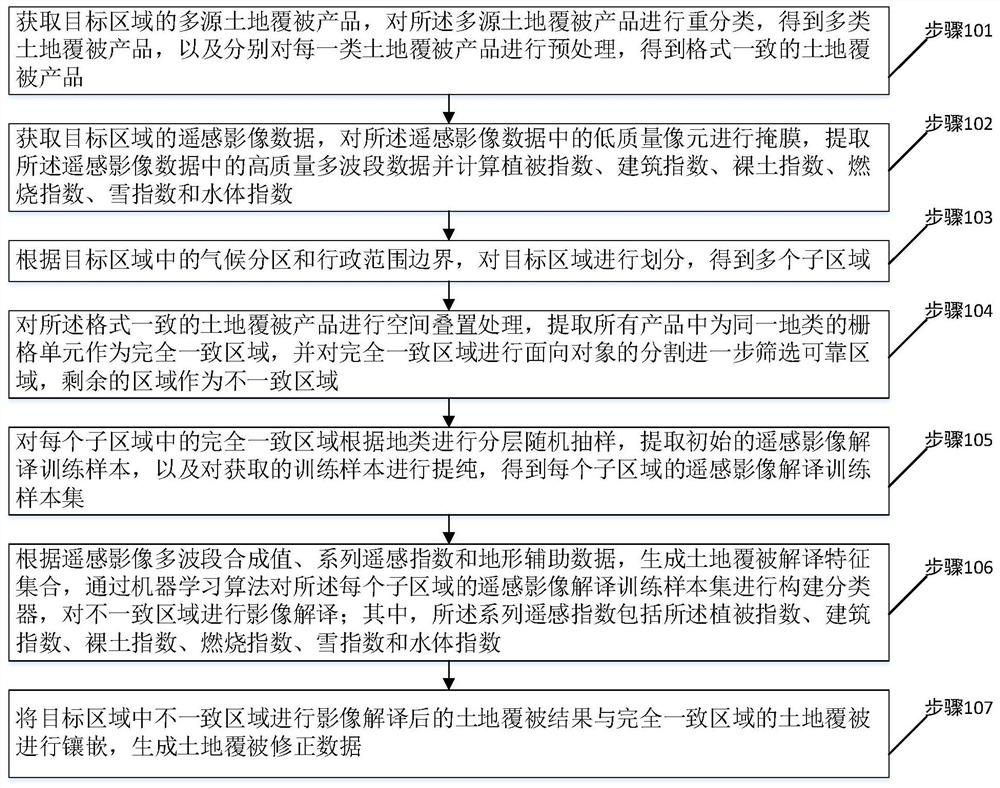
[0048] Please refer to figure 1 , a flow chart of the steps of a land cover mapping method provided in an embodiment of the present invention, including steps 101 to 107, each step is specifically as follows:
[0049] Step 101, obtain multi-source land cover products in the target area, reclassify the multi-source land cover products to obtain multiple types of land cover products, and perform preprocessing on each type of land cover products respectively to obtain Consistently formatted land cover products.
[0050] In this embodiment, before the reclassification of the multi-source land cover products, it includes: performing framing combined mosaic and mask extraction on each multi-source land cover product.
[0051] In this embodiment, the step of preprocessing each type of land cover product includes: performing unified processing on the spatial range and reference coordinate system of the land cover product; The format of the product is unified into a raster format; th...
PUM
 Abstract
Description
Claims
Application Information
 - R&D
- Intellectual Property
- Life Sciences
- Materials
- Tech Scout
- Unparalleled Data Quality
- Higher Quality Content
- 60% Fewer Hallucinations
Browse by: Latest US Patents, China's latest patents, Technical Efficacy Thesaurus, Application Domain, Technology Topic, Popular Technical Reports.
© 2025 PatSnap. All rights reserved.Legal|Privacy policy|Modern Slavery Act Transparency Statement|Sitemap|About US| Contact US: help@patsnap.com

