Power line carrier intelligent monitoring method and system of urban information model
A city model, power carrier technology, applied in information technology support systems, power network operating system integration, electrical components, etc., can solve the problems of limited and non-visual low-voltage power, stay, limited spatial range of propagation signals, etc. Simple processing and the effect of intelligent status monitoring
- Summary
- Abstract
- Description
- Claims
- Application Information
AI Technical Summary
Problems solved by technology
Method used
Image
Examples
Embodiment 1
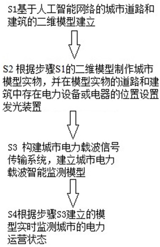
[0084] Such as figure 1 A power carrier intelligent monitoring method for a 3D printed city model, including S1 establishing a two-dimensional model of urban roads and buildings based on an artificial intelligence network; S2 making a 3D printed city model based on the two-dimensional model of step S1, and adding Install the AMOLED light-emitting device at the location where there are electric equipment or electrical appliances; S3 build the urban power carrier signal transmission system, and establish the urban power carrier intelligent monitoring model; S4 monitor the city's power operation status in real time according to the model established in step S3.
[0085] S1 specifically includes:
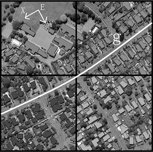
[0086] S1-1 The establishment of the urban road network model of the artificial intelligence network, specifically including: establishing the urban geographic coordinate system E (such as Figure 4 shown), the XOY plane represents the ground (X direction is north), based on the urban ...
Embodiment 2
[0097] This embodiment is a continuation of Embodiment 1. Such as image 3 and Figure 5 Taking urban buildings as an example, S2 specifically includes:
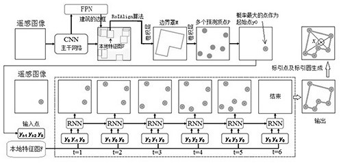
[0098] S2-1 The intersection of the longest and second longest diagonal lines in each polygonal boundary in the two-dimensional model of the urban building represents the index point of the building , and take the indexing point as the center r (the size can accommodate more than 10 AMOLED pixel elements) as the radius to form a building indexing circle ( image 3 ), so as to obtain a 2D model of urban roads and buildings with architectural indexing circles .
[0099] S2-2 Preset 2D model The Z coordinate H=w of the medium polygon boundary under E, forming a 3D model of urban buildings with architectural indexing circles ,Will The model data is imported into the 3D printing equipment, and a 3D printed city model with round holes for building and road markings is printed out ( Figure 5 );
[0100] S2-3 in A...
Embodiment 3
[0102] S3 specifically includes:
[0103] Described construction city power carrier signal transmission system comprises:
[0104] S3-1 Install PLC circuits on the power lines of urban roads and buildings to form PLC signals, and set concentrators in each division (existing in Figure 5 In the building at grid point g), it is used to receive the PLC signal and convert it into a wireless signal A through the wireless transmission module in the concentrator; wherein, the wireless signal A contains the index circle center in the corresponding road building The coordinate information under E and the modulation signal type information in PLC, the modulation signal type includes FSK, SSB, PSK, BPSK, QPSK, PAM, 16QAM.
[0105] S3-2 Set up a server 1 for receiving the wireless signal A sent by the concentrator that contains the coordinate information and the type information of the modulated signal in the PLC;
[0106] The establishment of the urban power carrier intelligent monitor...
PUM
 Abstract
Description
Claims
Application Information
 - R&D
- Intellectual Property
- Life Sciences
- Materials
- Tech Scout
- Unparalleled Data Quality
- Higher Quality Content
- 60% Fewer Hallucinations
Browse by: Latest US Patents, China's latest patents, Technical Efficacy Thesaurus, Application Domain, Technology Topic, Popular Technical Reports.
© 2025 PatSnap. All rights reserved.Legal|Privacy policy|Modern Slavery Act Transparency Statement|Sitemap|About US| Contact US: help@patsnap.com


