Supercharge Your Innovation With Domain-Expert AI Agents!

Data resampling method for interference imaging altimeter

A technology of interferometric imaging and resampling, which is applied in the direction of using re-radiation, reflection/re-radiation of radio waves, measuring devices, etc., which can solve the problem that the imaging altimeter data is not a regular rectangle, it is difficult to re-sample, and the two sides of the data are irregular and invalid. value and other issues to achieve the effect of accurate data points

Active Publication Date: 2021-09-17
NAT SPACE SCI CENT CAS
View PDF12 Cites 0 Cited by
  • Summary
  • Abstract
  • Description
  • Claims
  • Application Information

AI Technical Summary

Problems solved by technology

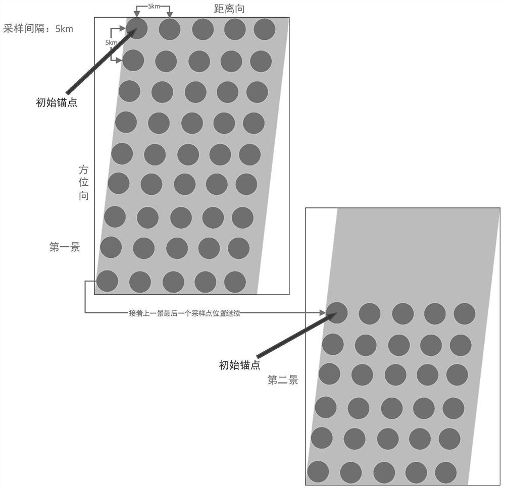
It is precisely because of this feature that the existing imaging altimeter data is not a regular rectangle, nor is it a parallelogram in the strict sense. It will produce irregular invalid values ​​​​on both sides of the data, making it difficult to resample

Method used


Image

  • Data resampling method for interference imaging altimeter
  • Data resampling method for interference imaging altimeter
  • Data resampling method for interference imaging altimeter

Examples


Embodiment 1

[0127] Such as image 3 As shown, the method includes:

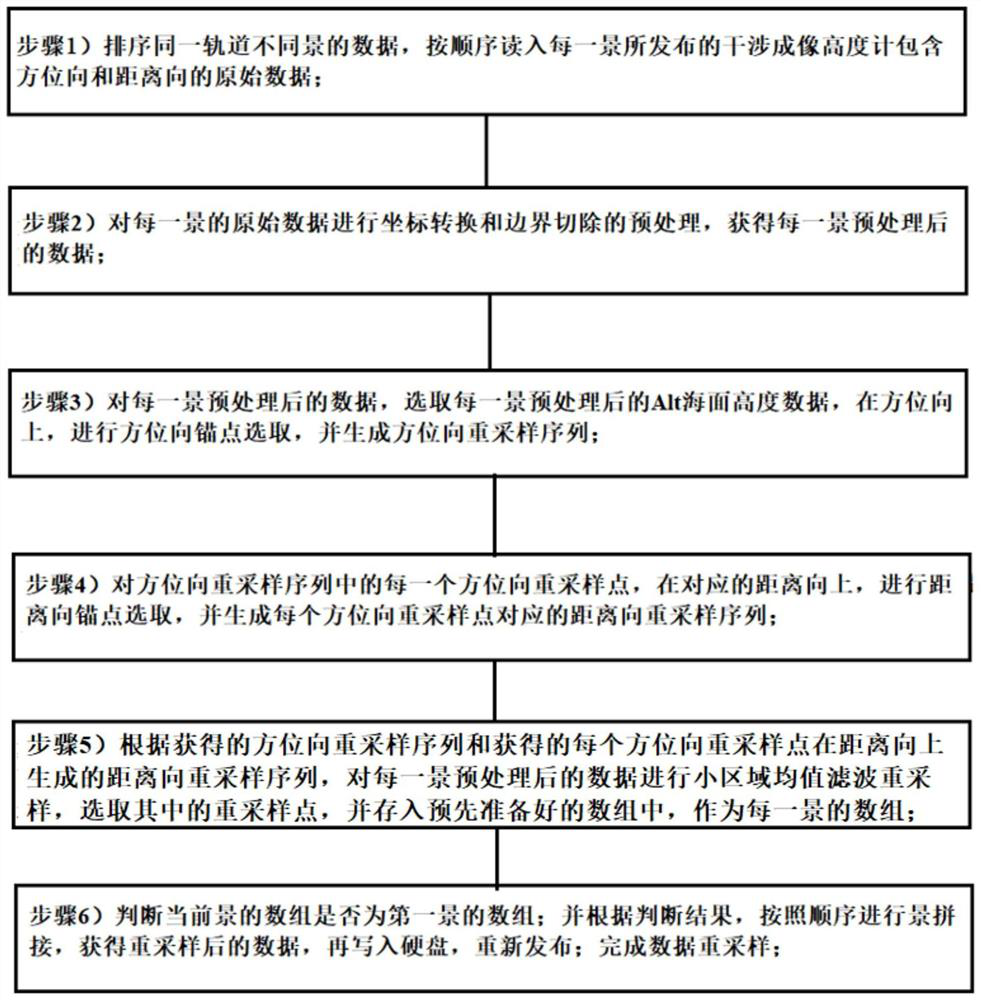
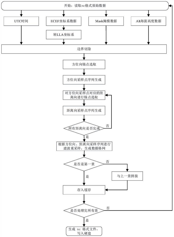
[0128] Step 1) Sort the data of different scenes in the same orbit, and read in the interferometric imaging altimeter issued by each scene in order, including the original data in azimuth and distance;

[0129] Step 2) Carry out the preprocessing of coordinate conversion and boundary cutting on the original data of each scene, and obtain the preprocessed data of each scene; wherein, such as image 3 As shown, the gray area can be regarded as densely packed data points, and the amount of data is very large. Therefore, data resampling is required; after preprocessing, the data points are cut off to obtain valid data, and effective The data is shaped like a parallelogram surrounded by invalid data points. Gray circles are filters.

[0130] Step 3) For the preprocessed data of each scene, select the Alt sea surface height data after the preprocessing of the first scene, and in the azimuth direction, carry out the azimuth ...


PUM


Abstract

The invention belongs to the technical field of height measurement data processing of a satellite altimeter, and particularly relates to a data resampling method for an interference imaging altimeter, which comprises the following steps of: 1) sorting data of different scenes in the same orbit, and reading original data of the interference imaging altimeter, which is published by each scene and comprises an azimuth direction and a distance direction in sequence; 2) carrying out coordinate transformation and boundary removal preprocessing on the original data of each scene to obtain preprocessed data of each scene; 3) generating an azimuth resampling sequence; 4) generating a range direction resampling sequence corresponding to each azimuth direction resampling point; 5) according to the results of the step 3) and the step 4), taking a filtering radius r as a small area, and performing small area mean value filtering resampling on the preprocessed data of each scene as an array of each scene; and 6) judging whether the array of the foreground is the array of the first scene or not, and splicing the scenes in sequence according to a judgment result to obtain resampled data.

Description

technical field [0001] The invention belongs to the technical fields of satellite altimeter height measurement data processing, radar signal processing, remote sensing information extraction and ocean parameter inversion, and in particular relates to a data resampling method for interference imaging altimeter. Background technique [0002] A satellite altimeter is an instrument for measuring the height of the sea surface, usually carried on a satellite platform. The altimetry principle of the traditional radar altimeter is to launch a cluster of microwave pulses to the sea surface, and the microwave pulses will be scattered after reaching the sea surface, and part of the backscattered energy will be received by the altimeter again. By measuring the time delay of the microwave pulses, the satellite platform can be obtained The precise distance R of the sea surface and the satellite orbit height H can be obtained by the global satellite navigation system, so the measurement of...

Claims


Application Information

Patent Timeline
Patent Type & Authority Applications(China)
IPC IPC(8): G01S13/90G01S13/88
CPCG01S13/9023G01S13/882
Inventor 孙孟张云华董晓石晓进
Owner NAT SPACE SCI CENT CAS
Features
  • R&D
  • Intellectual Property
  • Life Sciences
  • Materials
  • Tech Scout
  • Unparalleled Data Quality
  • Higher Quality Content
  • 60% Fewer Hallucinations
Learn More