
Ship heading and its area estimation method based on Beidou navigation and data-driven

A data-driven, Beidou navigation technology, applied in the field of navigation and positioning, can solve the problems of difficult ship equipment transformation, limited experimental environment characteristics, reduced search and rescue success rate, etc. , Solve the effect of insufficient positioning accuracy

Active Publication Date: 2022-01-07
浙江中裕通信技术有限公司
View PDF13 Cites 0 Cited by
  • Summary
  • Abstract
  • Description
  • Claims
  • Application Information

AI Technical Summary

Problems solved by technology

[0013] 2a. The methods based on signal processing, antenna design and multi-source fusion all achieve multi-path mitigation by adding / modifying hardware, which has the problem of doubling equipment volume / cost. It is difficult to transform existing ship equipment, which is not conducive to its propagation in small and medium-sized Promotion on
[0014] 2b. The signal classification and elimination method based on machine learning. The existing methods are all based on city construction, and the signal type calibration method of the data set related to this method is based on the rich environmental characteristics of the city and relies on external geographic information data, so it is limited The characteristics of the experimental environment, and the distribution of signal types in the urban environment is quite different from that of the ocean. In the city, this method mainly improves the positioning accuracy by eliminating NLOS (Non-Line-of-Sight, non-line-of-sight reception) signals. However, in an open environment such as the ocean, the probability of NLOS is very low, and multipath interference is the main problem, so it is not suitable for marine environments
[0016] 3a. The method based on positioning error is disturbed by geodetic factors, measurement noise and meteorological conditions. In coastal areas where the measurement data is not reliable, this may affect the captain’s decision-making and cannot play the role of navigation assistance, which will lead to an increase in the accident rate.
Moreover, the ship probability area delineated according to the error has no directionality, which may lead to an excessively large envelope area of ​​the delineated area, greatly increasing the difficulty of search and rescue. If the ship loses contact, the rescue success rate will be greatly reduced
[0017] 3b, the method based on optimal scheduling does not fundamentally improve the success rate of search and rescue, and optimizing the scheduling in the wrong area may reduce the success rate of search and rescue

Method used


Image

  • Ship heading and its area estimation method based on Beidou navigation and data-driven
  • Ship heading and its area estimation method based on Beidou navigation and data-driven
  • Ship heading and its area estimation method based on Beidou navigation and data-driven

Examples


Embodiment Construction

[0125] Embodiments of the present invention will be described below with reference to the accompanying drawings.

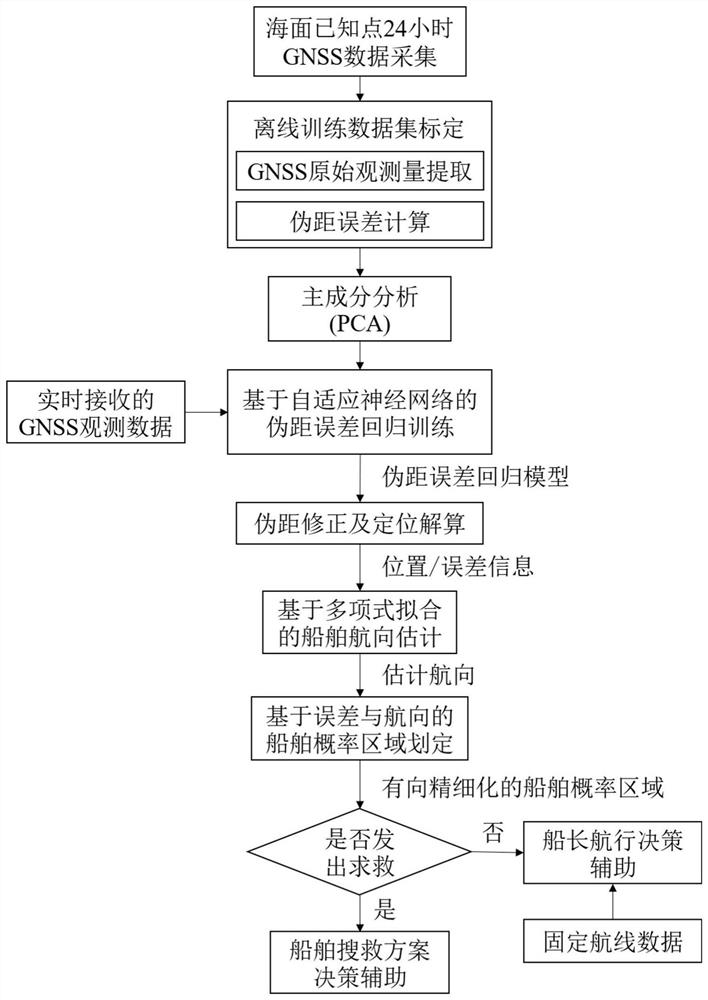
[0126] The embodiment of the present application provides a method for estimating the course of a ship and its area based on Beidou navigation and data drive, such as figure 1 shown, including the following steps:

[0127] Step 1, known points on the sea surface (X 0 ,Y 0 ,Z 0 ) to collect 24-hour GNSS observation data.

[0128] Step 2, obtain the offline calibration data set, the offline calibration data set includes the original observations and pseudorange errors extracted from the GNSS observation data:

[0129] Step 3, analyze and screen the original observations extracted from the GNSS observation data, and obtain the sample set Z after screening;

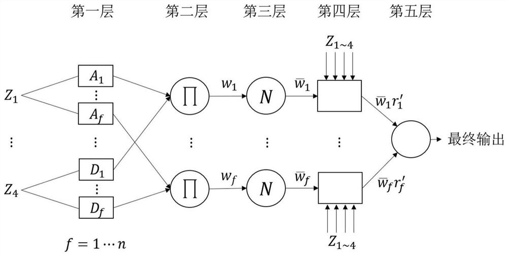
[0130] Step 4, input the sample set Z and the corresponding pseudorange error into the adaptive neural network ANFIS for training, extract the pseudorange error prediction rule, and obtain the pseudorange er...


PUM


Abstract

The invention discloses a ship heading and area estimation method based on Beidou navigation and data drive, including collecting 24-hour GNSS observation data at known points on the sea surface; obtaining offline calibration data sets; and extracting original observations from GNSS observation data Perform analysis and screening to obtain the sample set Z after screening; input the sample set Z and the corresponding pseudorange error into the adaptive neural network ANFIS for training, and obtain the pseudorange error regression model; input the newly received GNSS observation data into The pseudo-range error regression model predicts the pseudo-range error of the corresponding satellite in the epoch, obtains the corrected pseudo-range observation value, and performs positioning settlement on it to obtain an accurate positioning solution; estimates the ship's course; delineates the ship probability area. According to the obtained ship's navigation direction and ship probability area, the method can monitor the ship's yaw situation in real time and reduce the probability of marine traffic accidents.

Description

technical field [0001] The invention belongs to the technical field of navigation and positioning, and in particular relates to a ship heading and an area estimation method based on Beidou navigation and data drive. Background technique [0002] In recent years, maritime affairs are developing in the direction of electronic navigation integration, and autonomous navigation ships on the sea surface are gradually becoming popular. Although ship safety issues have been improved, there are still many problems in ship safety due to personnel negligence, misjudgment, and electronic equipment restrictions. risk. At present, the positioning and navigation of ships still depend on the Global Navigation Satellite System (GNSS). [0003] As an ideal maritime navigation tool, GNSS requires an accuracy of several meters (beach, wharf) to several hundred meters (on the way). The search and rescue difficulty, search and rescue manpower and material resources requirements and search and r...

Claims


Application Information

Patent Timeline
Patent Type & Authority Patents(China)
IPC IPC(8): G05B13/04
CPCG05B13/042
Inventor 傅麟霞林挺戴良波胡贤庆
Owner 浙江中裕通信技术有限公司
Learn More