Virtual space system based on geographic information

A technology of geographic information and virtual space, which is applied in the field of oil production engineering, can solve the problems of labeling and virtual space system not applicable to the use of complex space in oil production engineering, and achieve the effect of avoiding segmentation operations

Pending Publication Date: 2021-12-17
河北萁斗网络科技有限公司
View PDF0 Cites 1 Cited by
  • Summary
  • Abstract
  • Description
  • Claims
  • Application Information

AI Technical Summary

Problems solved by technology

[0003] Oil production engineering is usually carried out underground. Due to the complex underground environment, the commonly used virtual space system cannot mark the coordinate of depth, which makes the common virtual space system not suitable for complex space use in oil production engineering.

Method used


Image

  • Virtual space system based on geographic information
  • Virtual space system based on geographic information
  • Virtual space system based on geographic information

Examples


Embodiment Construction

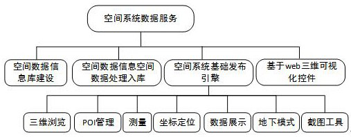
[0029] see Figure 1-9 , the present invention provides a technical solution: a virtual space system construction method based on geographical information is as follows:

[0030] S1. System layer construction:

[0031] The virtual space system is mainly composed of data layer, engine layer, operation and maintenance layer, service layer and application layer. The data layer includes geographic information data, geographic entity data, station data, image data, elevation data, 3D model data and vector data. , the data layer is based on multi-scale basic geographic information data, and is integrated and processed according to unified technical specifications;

[0032] The engine layer is the abstract processing application interface of geographic information technology for basic metadata, including remote sensing image data engine, address matching engine, map image engine, positioning engine, vector data engine and basic publishing engine interface and application services; ...


PUM


Abstract

The invention discloses a virtual space system based on geographic information, and relates to the technical field of oil production engineering, and the virtual space system comprises a system layer which is composed of a data layer, an engine layer, an operation and maintenance layer, a service layer and an application layer, and also comprises a function module, the function module is composed of a spatial data information base construction part, a spatial data information and spatial data processing and storage part, a spatial system basic publishing engine part and a web-based three-dimensional visualization control part. According to the method, the PostGIS is adopted to provide support for complex space objects and support space indexes, in the aspect of space operation, the PostGIS supports space operators and provides a space analysis function, a space aggregation function and a space maintenance function, in addition, in the aspect of space operation, the PostGIS provides the functions of space data coordinate projection system conversion, sphere length calculation and the like, and the space data coordinate projection system conversion function, the sphere length calculation function and the like are integrated. According to the method, space transportation is more accurate, and space management and analysis functions such as storage and management of space geographic data and geometric topology analysis can be provided for the PostGIS by expanding the PostgreSQL database through the PostGIS.

Description

technical field [0001] The invention relates to the technical field of oil production engineering, in particular to a virtual space system based on geographical information. Background technique [0002] Oil production engineering is the general term for various engineering and technical measures taken to the reservoir through production wells and injection wells according to the development objectives in the process of oilfield exploitation. As a comprehensive applied discipline, it studies the economical and effective , Theories, engineering design methods and implementation techniques of various engineering technical measures to improve oil well production and crude oil recovery. [0003] Oil production engineering is usually carried out underground. Due to the complex underground environment, the commonly used virtual space system cannot mark the coordinate of depth, so the common virtual space system is not suitable for the complex space use of oil production engineerin...

Claims


Application Information

Patent Timeline
Patent Type & Authority Applications(China)
IPC IPC(8): G06F16/957G06F16/29G06F16/904G06T15/20G06T15/80G06T17/05
CPCG06F16/957G06F16/29G06F16/904G06T17/05G06T15/205G06T15/80
Inventor 李凤民
Owner 河北萁斗网络科技有限公司
Why Eureka
Try Eureka