A monitoring method for construction status changes for large-scale engineering construction

A state-changing, large-scale engineering technology, applied in image enhancement, instrument, scene recognition, etc., can solve problems such as long statistical time, large statistical workload, and inability to obtain monitoring information, achieving high update rate, strong timeliness, and improved performance. The effect of the ability to apply

Active Publication Date: 2022-06-28
成都四象纵横遥感科技有限公司
View PDF9 Cites 0 Cited by
  • Summary
  • Abstract
  • Description
  • Claims
  • Application Information

AI Technical Summary

Problems solved by technology

However, most of the data obtained by the above methods come from data collection, which is restricted by the data source, data authenticity and validity. At the same time, the statistical workload is heavy and the statistical time is long, so it is impossible to obtain direct monitoring information.

Method used


Image

  • A monitoring method for construction status changes for large-scale engineering construction
  • A monitoring method for construction status changes for large-scale engineering construction
  • A monitoring method for construction status changes for large-scale engineering construction

Examples


Embodiment 1

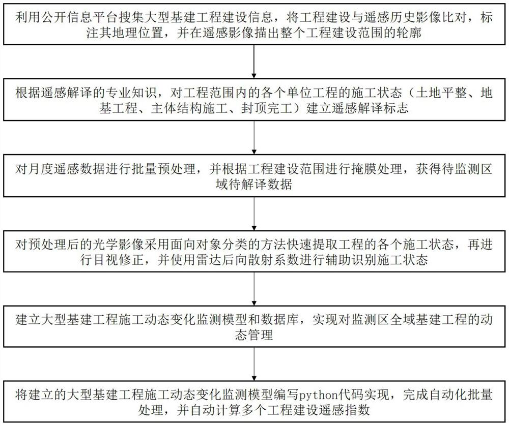
[0050] This embodiment provides a construction state change monitoring method for large-scale project construction,

[0051] Step 1: Obtain construction information of large-scale infrastructure projects in the past three years that are larger than 0.5 square kilometers in any administrative division;

[0052] Step 2: Compare the construction information with the historical impact of the high-resolution remote sensing of the infrastructure project, manually mark the geographic location of the infrastructure project, and trace the entire project construction range vector file in the remote sensing image;

[0053] Step 3: Collect remote sensing satellite images of the area to be monitored on a monthly basis, perform batch preprocessing, and perform mask processing according to the administrative division data to obtain preprocessed image data to be classified and processed;

[0054] Step 4: according to the technology of remote sensing interpretation, establish remote sensing in...

Embodiment 2

[0060] The construction information includes the geographic location of the project, the start time, the completion time, and the construction scope of the project. The step 3 is as follows: Step 301, according to the area to be monitored, collect monthly satellite remote sensing images for the past three years through optical remote sensing satellites to obtain optical image data; when the optical image data cannot be obtained due to the influence of climatic conditions, continue to supplement the collection Obtain the radar remote sensing satellite image of the missing time due to the area with poor optical remote sensing data quality, and obtain the radar image data, and the radar remote sensing satellite includes satellites; Step 302, obtain an optical image within the scope of the project by processing the optical image data; Step 303, By processing the radar image data, the radar image within the project construction range is obtained.

[0061] Specific working principle...

Embodiment 3

[0064] The step 4 is as follows:

[0065] Step 401, establishing a construction state classification model, including four states including land leveling, foundation engineering, main structure construction, and capping completion;

[0066] Step 402: Select the preprocessed image data to be classified and processed in September or October as the sample, determine the location range of the project to be monitored according to the project construction scope vector file, and select 3-5 projects as the sample;

[0067] Step 403: According to the surface features on the satellite image, manually interpret and delineate the images within the sample range, determine the construction status of each local area, and use each local area as a sample to form a vector file and a corresponding raster file, A sample sampling library is established, and the number of samples in each construction state is required to be no less than 5.

[0068] The specific working principle also includes:

...


PUM


Abstract

The invention discloses a construction state change monitoring method for large-scale engineering construction, relates to the technical field of time-series remote sensing image engineering construction monitoring, solves the problem that most of the existing engineering construction data comes from data collection, and is restricted by data sources, data authenticity and validity, At the same time, the statistical workload is large and the statistical time is long, and the technical problems of direct monitoring information cannot be obtained. The present invention proposes a rapid classification method for the construction status of infrastructure projects in a large area, using multi-scale segmentation and object classification processing technology, and Combined with the radar backscatter coefficient characteristics to assist in identifying the construction status, based on medium and high-resolution optical remote sensing and radar images, the whole process monitoring of the progress status of large-scale infrastructure projects across the country can be realized, and the most intuitive progress information of infrastructure projects can be obtained; A set of engineering construction dynamic change monitoring model.

Description

technical field [0001] The invention relates to the technical field of time series remote sensing image engineering construction monitoring, and more particularly relates to a construction state change monitoring method for large-scale engineering construction in a large area by using time-series multi-source remote sensing data. Background technique [0002] my country is in the era of rapid urbanization and industrialization, and investment in fixed assets is one of the main driving forces for economic development. Fixed asset investment statistics not only provide an important reference for the analysis and interpretation of national macro-control and economic development trends, but are also closely related to the state of my country's national economic development. In the long run, the cyclical changes in investment growth and economic growth have always maintained a high degree of correlation. . According to the definition of the National Bureau of Statistics, fixed as...

Claims


Application Information

Patent Timeline
Patent Type & Authority Patents(China)
IPC IPC(8): G06V20/13G06V10/26G06V10/44G06V10/774G06V10/764G06K9/62G06T7/00G06T7/62G06T5/50G06T5/00G06Q10/06G06Q50/08
CPCG06T7/0004G06T7/62G06T5/50G06T5/006G06T5/002G06Q10/0631G06Q50/08G06T2207/10044G06T2207/20221G06T2207/20132G06T2207/30132G06F18/24323G06F18/214
Inventor 郗晓菲郑勇俞雷赵路明祁国华商雨萌卢裕鸿孙帅旗
Owner 成都四象纵横遥感科技有限公司
Why Eureka
Try Eureka