High-temporal-spatial-resolution near-surface air temperature reconstruction method and system and equipment

A time-space resolution and air temperature technology, applied in the field of temperature estimation, can solve the problems of low quality, sparse distribution of stations, small coverage, etc., and achieve the effect of high applicability and improved accuracy

Pending Publication Date: 2022-02-08
INST OF AGRI RESOURCES & REGIONAL PLANNING CHINESE ACADEMY OF AGRI SCI
View PDF9 Cites 4 Cited by
  • Summary
  • Abstract
  • Description
  • Claims
  • Application Information

AI Technical Summary

Problems solved by technology

However, there are still some thorny problems in using weather stations for monitoring: due to the sparse and uneven distribution of weather stations in China, the data of weather stations in the western region is less than one-fifth of that in the eastern region, and most weather stations are located far away from cities sparsely populated areas, so it is impossible to accurately monitor urban temperature changes caused by the heat island effect
[0008] (1) In the existing monitoring methods using weather stations, due to the relatively sparse and uneven distribution of weather stations in China, the data of weather stations in the western region is less than one-fifth of that in the eastern region, and most weather stations are located far away Sparsely populated areas of the city, so it is impossible to accurately monitor urban temperature changes caused by the heat island effect
[0009] (2) A single meteorological station is distributed in the form of points with a small coverage area, which cannot meet the needs of large-scale regional research and cannot reflect the spatial differences in temperature
[0010] (3) The equipment of the weather station is easy to age, and the equipment is abnormally worn out, which requires a lot of manpower and material resources to maintain and manage the equipment of the weather station
[0011] (4) Existing interpolation methods, such as Kriging interpolation, cubic spline interpolation, inverse distance weight interpolation (IDW), etc., still need to be further developed to improve interpolation accuracy
[0012] (5) Among the existing methods for estimating temperature using the TVX method, different satellite sensors and research fields have large differences in the value of NDVI, and the relationship between surface temperature and NDVI_max may be disturbed by other factors
[0013] (6) Using the surface temperature obtained from remote sensing satellite data to infer temperature cannot eliminate the data deviation caused by the influence of clouds and rain and the different transit times of remote sensing satellites. The TVX method faces problems such as the difference in NDVI value estimates monitored by different sensors
[0014] (7) Existing reanalysis data focus more on daily temperature values ​​or other driving factors on the ground, but less research on daily maximum and minimum temperature values, and the spatial resolution of reanalysis data is low
[0015] (8) At present, the estimation of near-surface temperature is mostly based on interpolation of meteorological station data or remote sensing surface temperature data, which is still affected by the sparse distribution and small number of stations, and the impact of cloudy and rainy weather that reduces the accuracy of remote sensing images
[0016] In order to overcome the lack of spatial continuity of ground meteorological stations and the lack of continuity of remote sensing retrieval data in time, we make full use of the respective advantages of different data to build an air temperature reconstruction model. The reconstruction is missing or the quality is not high. the data value of

Method used


Image

  • High-temporal-spatial-resolution near-surface air temperature reconstruction method and system and equipment
  • High-temporal-spatial-resolution near-surface air temperature reconstruction method and system and equipment
  • High-temporal-spatial-resolution near-surface air temperature reconstruction method and system and equipment

Examples


Embodiment Construction

[0100] In order to make the object, technical solution and advantages of the present invention more clear, the present invention will be further described in detail below in conjunction with the examples. It should be understood that the specific embodiments described here are only used to explain the present invention, not to limit the present invention.

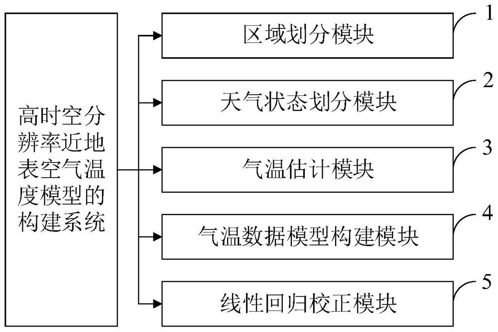
[0101] Aiming at the problems existing in the prior art, the present invention provides a method, system, and equipment for constructing a near-surface air temperature model with high temporal and spatial resolution. The present invention will be described in detail below in conjunction with the accompanying drawings.

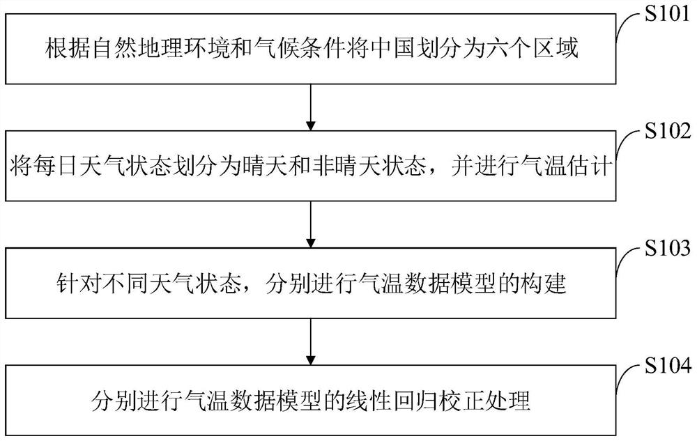
[0102] Such as figure 1 As shown, the construction method of the high temporal and spatial resolution near-surface air temperature model provided by the embodiment of the present invention includes the following steps:

[0103] S101, divide China into six regions according to the natural geographical enviro...


PUM


Abstract

The invention belongs to the technical field of temperature estimation, and discloses a high-temporal-spatial-resolution near-surface air temperature reconstruction method and system, and equipment, and the construction method of a high-temporal-spatial-resolution near-surface air temperature model comprises the steps: dividing the weather of 1979-2018 into weather under a sunny day condition and weather under a non-sunny day condition, and through an existing reanalysis data set; establishing daily maximum and minimum temperature models in different weather states to estimate maximum and minimum temperature values by utilizing meteorological station data and combining with hour temperature data of a Chinese surface meteorological element driven meteorological station and MODIS daily Ts, and obtaining a daily average temperature data set through summation and averaging; and after linear regression correction, finally outputting a Chinese daily value near-surface air temperature data set from 1979 to 2018, wherein the spatial resolution is 0.1 degree. The data set constructed by the method can better estimate the daily maximum temperature, minimum temperature and average temperature, and is convenient for further analyzing seasonal and periodic change conditions of the temperature in the Chinese region.

Description

technical field [0001] The invention belongs to the technical field of temperature estimation, and in particular relates to a method, system and equipment for reconstructing near-surface air temperature with high temporal and spatial resolution. Background technique [0002] At present, temperature is an important physical quantity that reflects the degree of coldness and heat and climate change. Understanding real-time changes in temperature is crucial to the study of global warming trends, urban heat island effects, ecological environment changes, vegetation phenology development, crop yield fluctuations, and energy dynamic balance. . Daily maximum temperature, minimum temperature and average temperature can reflect the fluctuation range of daily temperature, and are important input variables of crop models. Their changes are related to human production and life, vegetation growth, changes and development of ecological environment, biosphere, earth Chemistry and the water...

Claims


Application Information

Patent Timeline
Patent Type & Authority Applications(China)
IPC IPC(8): G01W1/00G01K13/024
CPCG01W1/00G01K13/024
Inventor 毛克彪方舒王平韩秀珍杨军邱玉宝吴学睿袁紫晋
Owner INST OF AGRI RESOURCES & REGIONAL PLANNING CHINESE ACADEMY OF AGRI SCI
Why Eureka
Try Eureka