Multi-view-field starry sky observation satellite target attitude planning method

A technology for observing satellite and target attitude, which is applied in the field of imaging area selection and attitude planning, and multi-field star observation satellite target attitude planning. Observe the effect of quality and guarantee effectiveness

Pending Publication Date: 2022-02-18
CHINA ACADEMY OF SPACE TECHNOLOGY
View PDF0 Cites 0 Cited by
  • Summary
  • Abstract
  • Description
  • Claims
  • Application Information

AI Technical Summary

Problems solved by technology

[0003] Since remote sensing satellites are designed for ground imaging requirements, there are some problems in imaging the starry sky, such as the limited number of observed celestial bodies due to the small field of view of the camera, and optical equipment (cameras, star sensors, etc.) At present, there is still a lack of corresponding observation sky area and target attitude planning methods in related fields
[0004] In addition to remote sensing satellites imaging the starry sky, some astronomical observation space science satellites need to image specific sky areas due to the needs of exploration missions. At present, in the literature on mission planning of astronomical observation satellites, more fixed-point targets are considered. The number of visits, extended observation time, minimization of energy consumption, and starry sky coverage and other issues rarely involve the attitude planning problem of multi-field cameras imaging the starry sky at the same time

Method used


Image

  • Multi-view-field starry sky observation satellite target attitude planning method
  • Multi-view-field starry sky observation satellite target attitude planning method
  • Multi-view-field starry sky observation satellite target attitude planning method

Examples


Embodiment

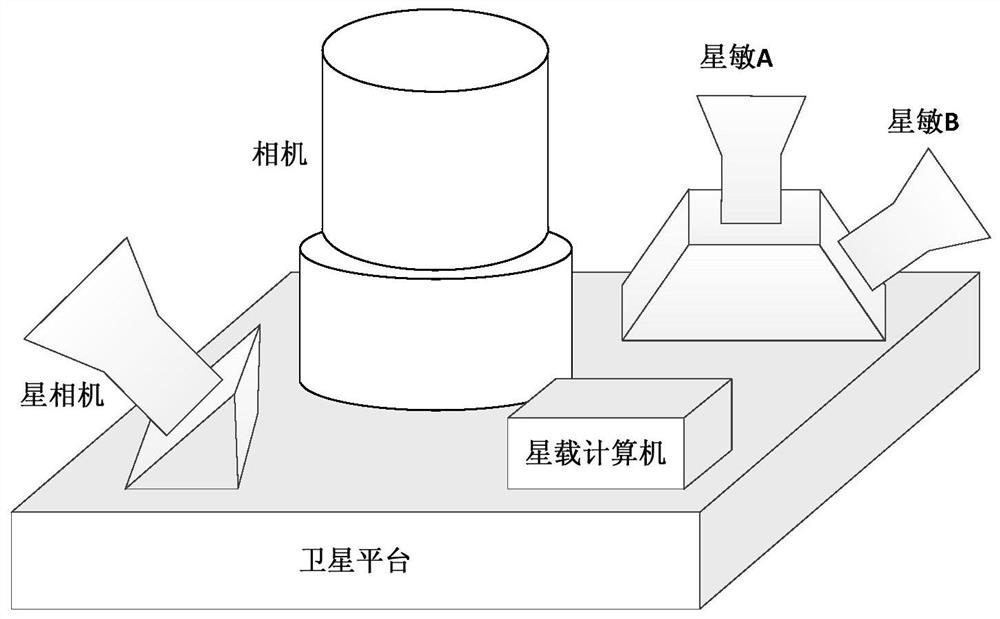
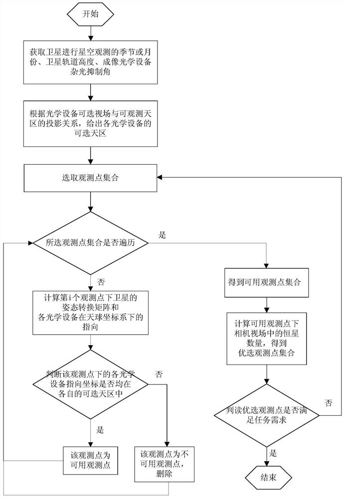
[0177] In this embodiment, the satellite is configured with one imaging camera, one star camera, and two star sensors. It should be noted that the number of cameras and the number of star sensors can be configured arbitrarily in practical applications. figure 1 A schematic diagram of the system composition of this embodiment is given, figure 2 The implementation flow chart of the method of the present invention is given, and the specific implementation of the present invention will be described in detail below in conjunction with the accompanying drawings.

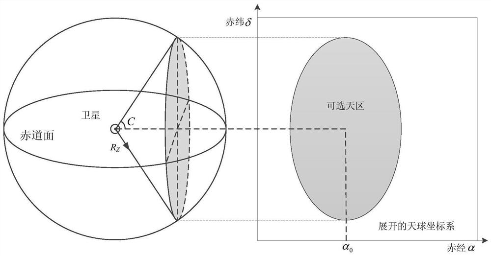
[0178] In step 1, according to the mission plan of the satellite, select the month or specific date for starry sky imaging, and choose to perform multi-field starry sky imaging in the shadow area, obtain satellite orbit data through satellite-ground measurement and control, and extrapolate to obtain the satellite orbit of the starry sky observation day Height, to simplify the calculation, when the satellite is in a circul...


PUM


Abstract

The invention relates to a multi-view-field starry sky observation satellite target attitude planning method, which comprises the following steps of: 1, acquiring seasons or months of starry sky observation of a satellite, a satellite orbit height and a stray light suppression angle of imaging optical equipment; 2, according to the projection relation between the selectable view field and the observable sky area of the optical equipment, providing the selectable sky area of each piece of optical equipment; 3, selecting an observation point set according to the distribution of fixed stars in the selectable sky area, obtaining the direction of each optical device under the observation point under the celestial coordinate system, judging whether the optical device is in the available sky area, and deleting unavailable observation points; 4, counting the number of fixed stars in the field of view of the camera under the available observation points, and optimizing the available observation points; and 5, repeating the steps 3 and 4 until a satisfactory observation point set is found, and outputting the right ascension and declination of the optimal observation point and a satellite attitude conversion matrix. According to the invention, ideal observation sky areas and target attitudes are provided for multi-view-field star sky imaging of remote sensing satellites and astronomical observation satellites.

Description

technical field [0001] The invention relates to a multi-field star observation satellite target attitude planning method, which belongs to the field of satellite target attitude planning and is applied to imaging region selection and attitude planning when remote sensing satellites and astronomical observation satellites perform multi-field starry imaging. Background technique [0002] When the payload of a remote sensing satellite is a camera, radiometric calibration or geometric calibration can be performed on star imaging, which requires multiple cameras or star sensors to simultaneously image the starry sky. [0003] Since remote sensing satellites are designed for ground imaging requirements, there are some problems in imaging the starry sky, such as the limited number of observed celestial bodies due to the small field of view of the camera, and optical equipment (cameras, star sensors, etc.) At present, there is still a lack of corresponding observation sky area and t...

Claims


Application Information

Patent Timeline
Patent Type & Authority Applications(China)
IPC IPC(8): G01C21/24G01C11/00
CPCG01C21/24G01C11/00
Inventor 王家炜景泉陈曦李少辉刘希刚高洪涛赵利民郭倩蕊王倩莹胡震岳
Owner CHINA ACADEMY OF SPACE TECHNOLOGY
Why Eureka
Try Eureka