
Satellite navigation/optical combined target detection method and system

A technology for target detection and satellite navigation, applied in the field of satellite navigation, can solve the problems of imaging quality restricting recognition speed and accuracy, and achieve the effect of facilitating rapid deployment, ensuring high quality, and solving the difficulty of both recognition speed and accuracy.

Inactive Publication Date: 2022-03-18
湖南天巡北斗产业安全技术研究院有限公司
View PDF7 Cites 0 Cited by
  • Summary
  • Abstract
  • Description
  • Claims
  • Application Information

AI Technical Summary

Problems solved by technology

[0003] Aiming at the deficiencies of the prior art, the present invention provides a target detection method based on satellite navigation / optical combination, which solves the problem that the imaging quality restricts the recognition speed and accuracy, and specifically adopts the following technical solutions:

Method used


Image

  • Satellite navigation/optical combined target detection method and system
  • Satellite navigation/optical combined target detection method and system
  • Satellite navigation/optical combined target detection method and system

Examples


Embodiment Construction

[0028] In order to enable those skilled in the art to better understand the solutions of the present invention, the technical solutions in the embodiments of the present invention will be clearly and completely described below in conjunction with the drawings in the embodiments of the present invention. Obviously, the described embodiments are only It is a part of embodiments of the present invention, but not all embodiments. Based on the embodiments of the present invention, all other embodiments obtained by persons of ordinary skill in the art without creative efforts shall fall within the protection scope of the present invention.

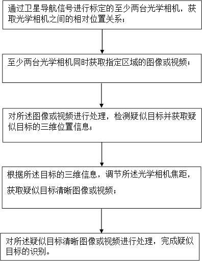
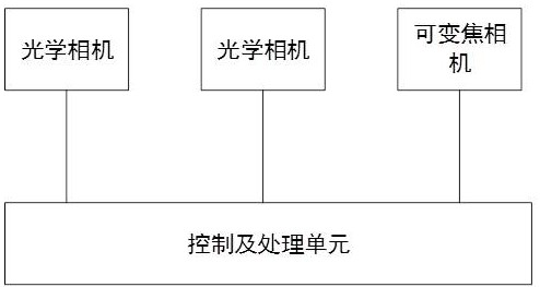
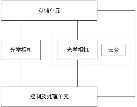
[0029] The present invention will be further described in detail below in conjunction with the drawings and specific embodiments of the description. The present invention provides a satellite navigation / optical combination target detection method and system, figure 1 A schematic flow diagram of the method of this embodiment is shown, including: ...


PUM


Abstract

The invention discloses a satellite navigation / optical combined target detection method and system, and the method comprises the steps: calibrating at least two optical cameras through a satellite navigation signal, and obtaining the relative position relation between the optical cameras; the at least two optical cameras simultaneously acquire images or videos of a specified area; processing the target image or video, detecting a target and acquiring three-dimensional position information of the target; processing the image or the video, detecting a suspected target and acquiring three-dimensional position information of the suspected target; adjusting the focal length of the optical camera according to the three-dimensional information of the target, and obtaining a clear image or video of a suspected target; and processing the clear image or video of the suspected target to complete recognition of the suspected target. The position of a suspected target can be rapidly and accurately measured, the cost is low, the distance measurement precision is high, the satellite navigation positioning technology is introduced to calibrate the position of the optical camera, a coordinate system is unified, and rapid deployment of the system is facilitated.

Description

technical field [0001] The invention relates to the field of satellite navigation, in particular to a satellite navigation / optical combination target detection method and system. Background technique [0002] With the rapid development of UAV technology, "low, slow and small" UAVs that use satellite positioning for navigation have developed rapidly and are widely used. While bringing convenience to industrial production and mass consumption and entertainment, it also brings great benefits to the existing air defense system and the country. Security and social stability pose new threats. "Low, slow and small" UAVs have the characteristics of low flying height, slow flying speed, and small flying volume, which brings certain difficulties to the detection of UAVs. Currently, the "low, slow and small" UAV target detection and recognition Photoelectric means mainly include laser ranging, visible light imaging, infrared imaging, etc., and the speed and accuracy of photoelectric d...

Claims


Application Information

Patent Timeline
Patent Type & Authority Applications(China)
IPC IPC(8): G01S19/48G01S11/12
CPCG01S19/485G01S11/12
Inventor 钟小鹏陈振宇刘春阳
Owner 湖南天巡北斗产业安全技术研究院有限公司
Learn More