Visual analysis platform for vehicle track-guided geographic spatial-temporal characteristics

A vehicle trajectory and spatiotemporal feature technology, which is applied in the field of geographic spatiotemporal feature visualization analysis platform and vehicle track-guided geographic spatiotemporal feature visualization analysis platform, can solve problems such as weak semantic information analysis ability, lack of data management model, lack of storage and management, etc. Achieve the effect of high matching degree, easy integration and good practical value

Pending Publication Date: 2022-04-01
刘心亮
View PDF0 Cites 2 Cited by
  • Summary
  • Abstract
  • Description
  • Claims
  • Application Information

AI Technical Summary

Problems solved by technology

[0008] First, as a typical spatio-temporal data, the trajectory data of moving vehicles integrates time and location information, with frequent location updates and rich information. As a typical representative of the big data era, moving vehicle trajectory data implies that people live in cities Various social activity information such as travel behavior in the network provides an effective data set for traffic flow analysis and urban planning, but the existing technology lacks storage and management of these moving entities, which provide traffic flow analysis, support for urban planning, geographical spatio-temporal characteristics and Analysis of hotspots provides effective support tools;
[0009] Second, traditional databases such as Oracle and SQLServer in the existing technology have very limited ability to store and analyze initial trajectory data; existing trajectory data models such as DOMINO and SECONDO rarely involve the storage and analysis of semantic information. The trajectory data model of the technology needs to expand the existing SQL syntax. These databases will have some shortcomings when storing and analyzing the semantic information of moving vehicles. Currently, there is a lack of a reasonable design that can combine semantic information analysis and only need to use pure SQL language Data management model for trajectory spatiotemporal feature pattern query;
[0010] Third, in terms of the data organization model of moving vehicle trajectories, a direct and effective method is to expand the point / line / surface types of the existing spatial modules in the database system to express and organize the point string data of the trajectories; but the data model and semantic information The connection is not obvious; the existing technology takes into account the two requirements of transaction processing and online analysis, and proposes a track organization model integrating E-R mode and Star mode to manage the driving track of trucks, but both need to expand the traditional SOL language to achieve the purpose of query, and cannot Analyzing the complex spatio-temporal association relationship between expressing trajectory and multi-type geospatial elements, lacking a spatiotemporal correlation trajectory model associated with geospatial information, and lacking examples of query analysis completed in pure SQL language;
[0011] Fourth, trajectory data is growing explosively. Various databases in the prior art always have their own limitations in the semantic storage and analysis of trajectory data, or the ability to store and analyze raw trajectory data is very limited, or rarely involves The storage and management of semantic information, the existing technology database has obvious disadvantages in storing and analyzing the initial trajectory data, and at the same time, the ability to analyze the semantic information contained in the trajectory is weak, lacking a geographic association trajectory database based on the STOP / RUN model, which cannot be combined with reality The stay-movement-stay behavior of moving vehicles in the world cannot construct and fill a geographically associated trajectory database, and cannot expand the three types of trajectory spatiotemporal feature patterns such as position-time, position-sequence, position-relationship, and analysis of popular points of interest. Unable to provide an effective data set management and analysis platform for traffic flow analysis, urban planning, analysis of popular attractions, etc.

Method used


Image

  • Visual analysis platform for vehicle track-guided geographic spatial-temporal characteristics
  • Visual analysis platform for vehicle track-guided geographic spatial-temporal characteristics
  • Visual analysis platform for vehicle track-guided geographic spatial-temporal characteristics

Examples


Embodiment Construction

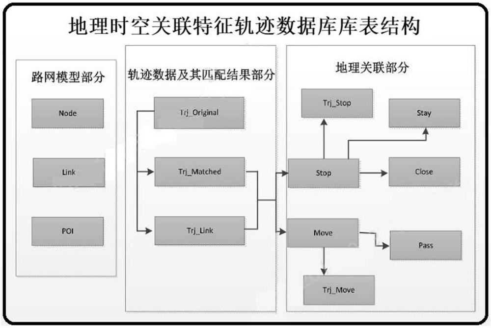
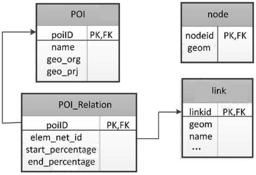
[0106] In the following, the technical solution of the vehicle trajectory guidance geographic spatio-temporal feature visualization analysis platform set up in this application will be further described in conjunction with the accompanying drawings, so that those skilled in the art can better understand the application and implement it.

[0107] With the continuous development and integration of satellite positioning technology, sports equipment and sensor network technology, various trajectory data are widely collected, resulting in an explosive growth of trajectory data. Semantic storage and analysis always have their own limitations; moving object trajectory data, as a typical representative of the big data era, implies various social activity information such as people's travel behavior in the city, and provides important information for traffic flow analysis, urban planning, The analysis of popular attractions etc. provides effective data sets, and how to store and manage ...


PUM


Abstract

On the basis of an Oracle network data model and a Stop / Run model, a database table structure for realizing a geographic space-time associated feature trajectory database is designed, including association of stay and motion behaviors in geographic space data and trajectory data, an Oracle NDM road network model is constructed according to OSM open source data, map matching is carried out on vehicle trajectory data, and a geographic space-time associated feature trajectory database is obtained. According to a matching result, acquiring stop and motion information in a vehicle driving process, associating the stop and motion information with point / line space elements by means of a space connection method, and constructing and filling a geographically associated track database; by taking a typicality retrieval request as an example, position-time, position-sequence and position-relationship trajectory spatial-temporal characteristic mode query and hot interest point analysis are performed, a new thought is provided for solving urban traffic and planning problems, the motion entities are effectively stored and managed, and the urban traffic planning method has the advantages of being high in practicability and easy to popularize. And powerful support is provided for traffic flow analysis, urban planning and hot scenic spot analysis.

Description

technical field [0001] The present application relates to a visual analysis platform for geographic spatio-temporal features, in particular to a visual analysis platform for geographic spatio-temporal features guided by vehicle trajectories, and belongs to the technical field of geographic spatio-temporal feature visualization analysis. Background technique [0002] In recent years, the process of urbanization has accelerated, and more and more cars are driving on urban roads, resulting in continuous deterioration of road traffic conditions and causing many social problems. How to alleviate the urban traffic pressure and improve the traffic environment has aroused widespread concern. [0003] With the continuous development and integration of satellite positioning technology, mobile communication technology, sports equipment and sensor network technology, the gradual rise and popularization of applications such as the Internet of Things, smart cities and intelligent transpor...

Claims


Application Information

Patent Timeline
Patent Type & Authority Applications(China)
IPC IPC(8): G06F16/21G06F16/2457G06F16/26G06F16/29
Inventor 刘心亮
Owner 刘心亮
Why Eureka
Try Eureka