
Map construction method and system, vehicle terminal, server side and storage medium

A map construction, server-side technology, applied in the server-side, storage medium, and vehicle terminal fields, can solve the problems of low accuracy, unutilized vehicle trajectory information, and large calculation amount of positioning map generation, achieving high satisfaction and convenient data. Obtain and establish, meet the effect of path planning and navigation needs

Pending Publication Date: 2022-05-17
CHANGCHUN YIHANG INTELLIGENT TECH CO LTD
View PDF0 Cites 2 Cited by
  • Summary
  • Abstract
  • Description
  • Claims
  • Application Information

AI Technical Summary

Problems solved by technology

[0006] In view of this, the object of the present invention is to provide a map construction method, system, vehicle terminal, server end and storage medium to solve the problem of large amount of calculation and low precision in the generation of positioning maps in the prior art and the problem of generating positioning maps. The problem that the vehicle trajectory information is not used

Method used


Image

  • Map construction method and system, vehicle terminal, server side and storage medium
  • Map construction method and system, vehicle terminal, server side and storage medium
  • Map construction method and system, vehicle terminal, server side and storage medium

Examples


Embodiment 1

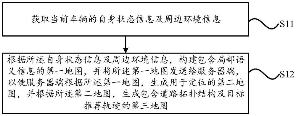
[0079] figure 1 is a flowchart of a method for constructing a map according to an exemplary embodiment, the method is applied to a vehicle terminal, such as figure 1 As shown, the method includes:

[0080] Step S11, obtaining the current vehicle's own state information and surrounding environment information;

[0081] Step S12: Construct a first map containing local semantic information according to the self-state information and surrounding environment information, and send the first map to the server, so that the server can generate a map for use according to the first map. The second map is positioned, and according to the second map, a third map including road topology and target recommended trajectory is generated.

[0082] It should be noted that the technical solution provided in this embodiment is applicable to the technical fields of automatic driving and assisted driving, and is especially applicable to the scene of map construction based on crowdsourcing data.

...

Embodiment 2

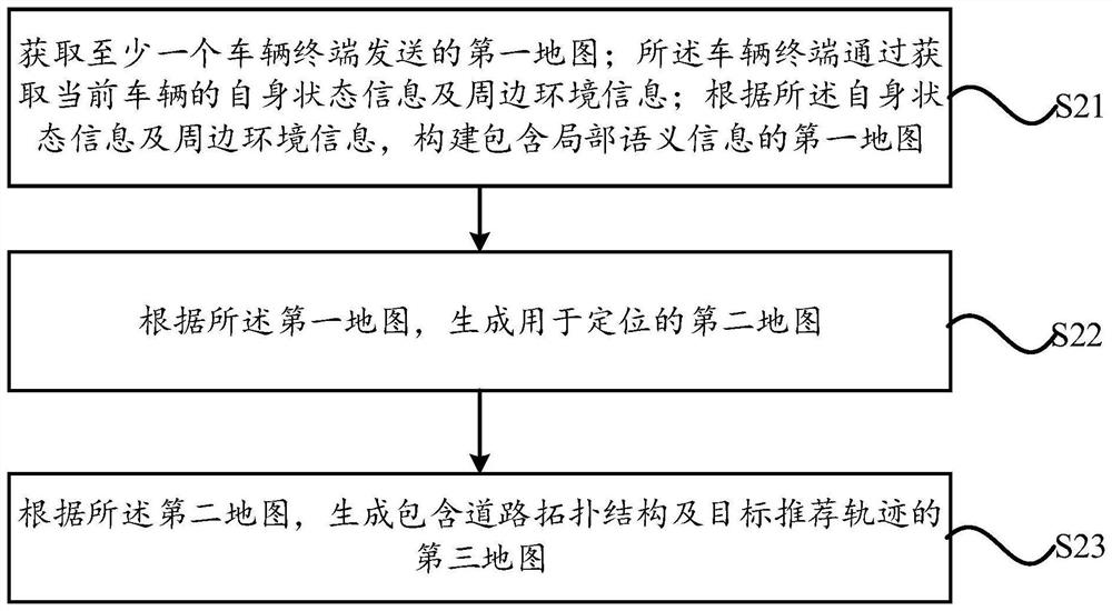
[0130] figure 2 is a flowchart of a method for constructing a map according to another exemplary embodiment, the method is applied on the server side, such as figure 2 As shown, the method includes:

[0131] Step S21. Obtain the first map sent by at least one vehicle terminal; the vehicle terminal obtains the current vehicle's own state information and surrounding environment information; according to the self state information and surrounding environment information, constructs the first map containing local semantic information. map;

[0132] Step S22, generating a second map for positioning according to the first map;

[0133] Step S23, according to the second map, generate a third map including road topology and target recommended trajectory.

[0134] It should be noted that the technical solution provided in this embodiment is applicable to the technical fields of automatic driving and assisted driving, and is especially applicable to the scene of map construction ba...

Embodiment 3

[0236] A vehicle terminal shown according to an exemplary embodiment is used to execute the map construction method described in the first embodiment.

[0237] It should be noted that the technical solution provided in this embodiment is applicable to the technical fields of automatic driving and assisted driving, and is especially applicable to the scene of map construction based on crowdsourcing data.

[0238] In specific practice, the vehicle terminal exists in the form of program code (including but not limited to the form of program function modules, or the form of APP), which is directly loaded in the central control system of the current vehicle; or, the vehicle terminal Exist in the form of program code, stored in the storage device connected to the vehicle's central control system, the central control system realizes the corresponding map building function by calling the program; or, the vehicle terminal exists in the form of on-board electronic equipment (eg, an elec...


PUM


Abstract

The invention relates to a map construction method and system, a vehicle terminal, a server side and a storage medium, and the method comprises the steps: building a first map containing local semantic information at the vehicle terminal, building a second map for positioning at the server side, and building a third map containing a road topological structure and a target recommendation trajectory; the problems that in the prior art, the calculation amount is large and manufacturing is difficult due to the fact that an original image is directly used for constructing the second map are solved. Besides, the second map used for positioning is constructed based on the first map, and the first map contains the local semantic information of the surrounding environment of the vehicle, so that the transmission data volume is low, and data acquisition, establishment and manufacturing of a high-precision map are facilitated. Moreover, according to the technical scheme provided by the invention, the vehicle track information for generating the second map is utilized, and compared with the prior art, the algorithm function integration degree is higher, the personalized path planning and navigation requirements of the user can be better met, the user experience degree is better, and the satisfaction degree is higher.

Description

technical field [0001] The present invention relates to the technical field of map construction, in particular to a map construction method, system, vehicle terminal, server end and storage medium. Background technique [0002] In the field of autonomous driving, the production of high-precision maps is essential. The traditional high-precision map production method is: Carrying GPS-RTK (RTK is also called carrier phase difference: the reference station transmits its carrier observation data and station coordinate information to the user station in time through the data link. The user station receives the carrier phase of the GPS satellite. With the carrier phase from the reference station, and form phase difference observations for timely processing, it can give centimeter-level positioning results in time), high-precision IMU, camera, Lidar and other sensors to collect data and send it to the cloud server, cloud server After data processing and manual editing, a high-prec...

Claims


Application Information

Patent Timeline
Patent Type & Authority Applications(China)
IPC IPC(8): G01C21/00G06F16/29G06V10/46G06K9/62G06N3/04G06T7/73
CPCG01C21/3863G06T7/73G06F16/29G06N3/047G06N3/045G06F18/241G06F18/2415
Inventor 李一龙范圣印韩鸿毅金凌鸽
Owner CHANGCHUN YIHANG INTELLIGENT TECH CO LTD
Learn More