Radio combined positioning method based on digital broadcasting-television signal

A technology of digital broadcasting and television combined positioning, applied in satellite radio beacon positioning system, radio wave measurement system, measuring device, etc., can solve problems such as delayed emergency rescue work, positioning error, GPS satellite positioning interference, etc.

Inactive Publication Date: 2006-05-24
SOUTHEAST UNIV
View PDF0 Cites 17 Cited by
  • Summary
  • Abstract
  • Description
  • Claims
  • Application Information

AI Technical Summary

Problems solved by technology

[0003] However, satellite positioning technologies such as GPS still have many shortcomings: GPS satellites transmit signals to the ground from an altitude of about 20,000 kilometers, and positioning errors will occur due to multipath effects, GPS satellite orbit errors, ionospheric delay effects, etc.; The positioning probability in the area is 60%, while the positioning probability indoors is zero, so it is difficult to use GPS technology for emergency rescue positioning; the real-time positioning of GPS technology is poor, and it takes 30s or more to complete

Method used


Image

  • Radio combined positioning method based on digital broadcasting-television signal
  • Radio combined positioning method based on digital broadcasting-television signal
  • Radio combined positioning method based on digital broadcasting-television signal

Examples


Embodiment Construction

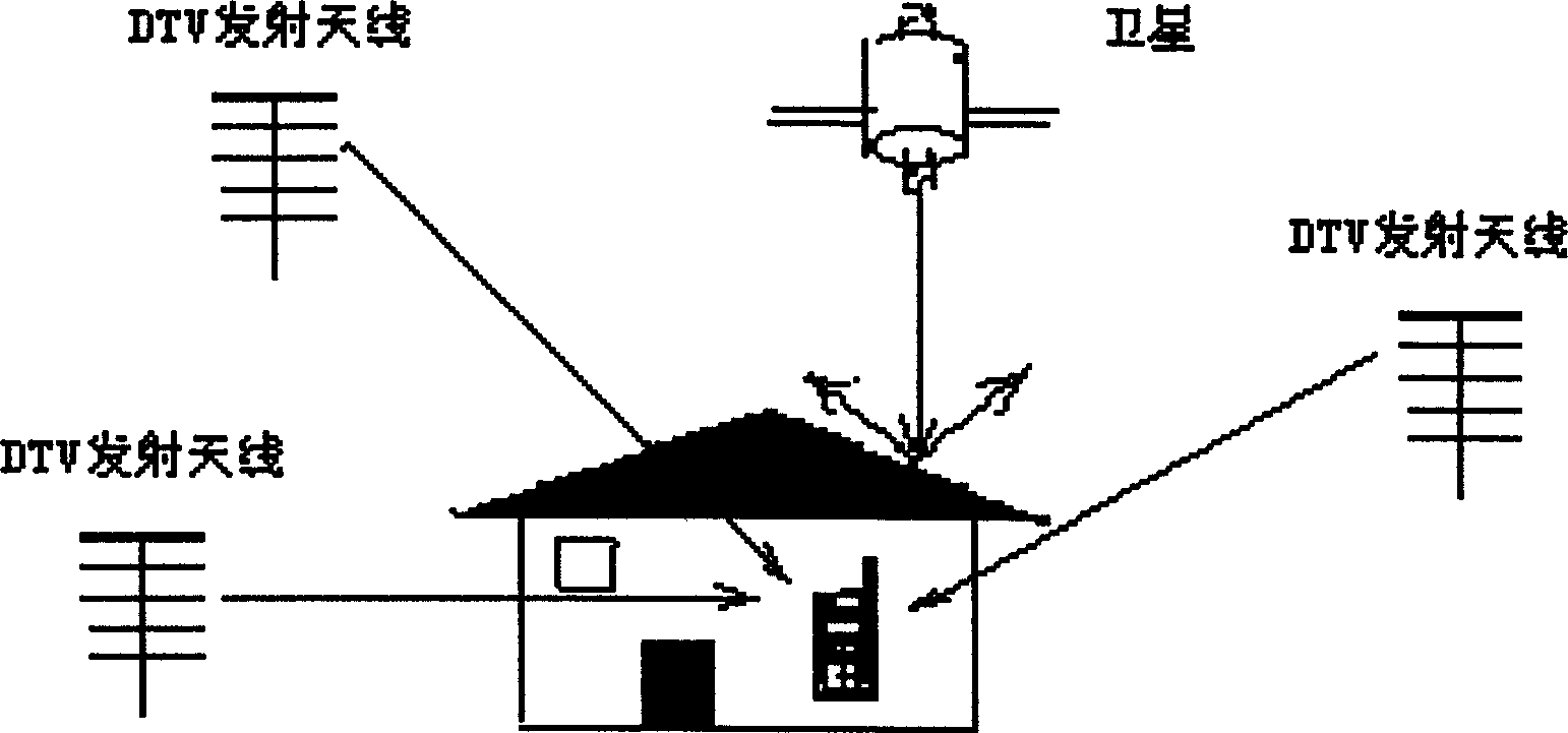
[0059] The advantage of combined positioning and navigation is to give full play to the advantages of each subsystem to obtain the optimal navigation state solution. This brand-new navigation and positioning mode proposed by the present invention, that is, the satellite-assisted terrestrial digital TV broadcast signal navigation and positioning system can not only combine navigation, but also satisfy the two subsystems to provide navigation information independently. When one sub-positioning system cannot provide observation values , the whole system can calculate the navigation solution according to the adaptive observations.

[0060] The whole system can be divided into two parts: transmitting and receiving. The launch part is based on the established DTV terrestrial broadcast signal launch station and DTV broadcast satellite. First, different system identification codes (IDs) are assigned to different transmission sources, and then the information such as the spatial coord...


PUM


Abstract

Syncretizing DTV terrestrial broadcasting with satellite broadcasting signal, the disclosed positioning and navigating method raises positioning performance. Receiving signals of civil DTV ground transmitting station and/or DTV broadcast satellite and navigation satellite with multiple space coordinates are known, the method determines space position of receiver. Being built on broadcast transmission system of radio signal, the method receives signals from radio broadcast systems and observes multiple emission sources to form system structure of combining multiple wireless positioning system and mode of position and navigation so as to obtain navigating solution of combined positioning system. All new operating mode of combined navigating system includes two types of wireless positioning system for observing ground and space at same time in the invention.

Description

technical field [0001] The invention is a method for determining the spatial position of the receiver by receiving signals from a plurality of civilian digital TV ground transmitting stations and / or digital TV broadcasting satellites with known spatial coordinates, belonging to digital TV broadcasting and radio navigation and positioning Composite technology field. Background technique [0002] Simultaneously receiving the radiation signals of multiple radio transmission sources with known spatial coordinates and time references, the geographical location of the user at the receiving end can be determined, that is, longitude, latitude and altitude (altitude). And positioning systems that set radio transmission sources on various orbiting satellites, such as: the Global Positioning System (GPS) of the United States, the Galileo (Galileo) system of Europe, the GLONASS system of Russia, and the "Beidou" positioning system of my country, etc. With the huge advantage of wide-area...

Claims


Application Information

Patent Timeline
IPC IPC(8): G01S19/46
Inventor 吴乐南何峰
Owner SOUTHEAST UNIV
Why Eureka
Try Eureka