Accurate geographic tracking of mobile devices

a mobile device and accurate technology, applied in the field of accurate geographic tracking of mobile devices, can solve the problems of not providing the high level of location accuracy necessary in many modern applications, gps signals that do not provide accuracy to five inches or less, and gps systems that do not work as well indoors

Active Publication Date: 2020-05-05
POSITION IMAGING
View PDF178 Cites 1 Cited by
  • Summary
  • Abstract
  • Description
  • Claims
  • Application Information

AI Technical Summary

Benefits of technology

[0027]An accurate and intuitive approach for interfacing with devices having RF capabilities, such as HMDs, mobile devices and the like, without camera gesture tracking, can enable new use cases and more effective control of content shown on these devices. As most HMDs will have radio communication capabilities, a means to leverage this functionality to enable interaction is helpful and economical. A method to enable HMDs to use their basic radio communication to accurately track their own position as well as the position of input devices in free space can enable better interaction as well as reduce costs.
[0028]The HMD would have two or more antennae embedded in or mounted to the HMD. A multifrequency transmitter, such as an Access Point, provides two or more frequency signals to the two or more HMD antennae. The HMD uses these two signals as received at each antenna to identify the range between the antenna and the Access Point. Then, using both (for two HMD antennae) ranges from either one or more Access Points with known position coordinates and the heading and orientation as supplied by inertial sensors in the HMD, the HMD can determine accurate position information.
[0030]The present disclosure also provides the ability for an HMD to accurately track the relative three-dimensional position of a wireless transmitting device such as an RFID device, or such as a phone, ring, wristband, stylus, handheld pointer, or related interactive peripheral device, (“Tag”), using the same multifrequency transmitting method described above for Access Points communicating range to the HMD. This relative position tracking would provide a flexible and intuitive approach for HMD interaction. Tags could become intuitive, interactive peripherals for HMDs and provide a unique and effective means to engage with programs displayed on the device without requiring a mouse, trackpad, camera, or related input solution.
[0031]HMDs can track the position of a Tag and use the position data to engage with a software program running or displayed on the device. In these applications, the Tag position and movement would be registered with screen images provided by software and shown on the HMD. To make this Tag's operation effective for a user (to control a cursor on a screen for example), very high position accuracies are required to provide realistic interaction between the user operating the Tag and the software program shown on the HMD. Herein is described a method that can provide said tracking capability for the HMD to meet the accuracy and cost requirements of these devices but also work with hardware constraints inherent in the size and ergonomic restrictions of HMDs.
[0032]In one embodiment of the present disclosure there is a system that allows Mobile Devices such as augmented or virtual reality glasses, robots, drones, handheld communicators (mobile phones) or scanners, or any mobile peripheral (Mobile Device) with radio frequency (RF) communication capability and multiple antennae embedded or attached to the mobile device, to track other devices that emit electromagnetic or RF signals (Other Devices) relative position to the Mobile Device. Further, when multiple Mobile Devices are present, each can calculate and communicate its own position relative to other devices, and the web of devices can provide a means for more efficiently and accurately tracking other devices. In addition, the Mobile Device may determine its actual outdoor or indoor position by utilizing certain stationary devices (Access Points) with RF communication capability and the ability to provide the Mobile Device with the Access Points' two or three-dimensional position coordinates. This position can then be relayed to other Mobile Devices or to a tracking center in certain use cases.

Problems solved by technology

However, GPS signals do not provide accuracy to five inches or less as would be desirable in a Virtual Reality (VR) and Augmented Reality (AR) systems.
GPS systems do not work as well indoors.
Such a system is a proximity indicator, and does not provide a high level of location accuracy necessary in many modern applications.
However, to date, such systems have accuracy of about a meter, which is not adequate for real time tracking of position in many applications.
However, analysis of the returned signal only provides a distance measurement from the transmitter to the RFID tag.
But, in these camera-based systems, gesture tracking can be limited by the field of view of the camera, accuracy of the camera gesture tracking, range detection of the hand position as viewed by HMD cameras, or the lack of tactile input to the hand or fingers as they are interacting with the program running on the HMD.
This make the systems difficult to properly configure and impractical for certain uses.
The geographic area in which objects may be tracked is typically limited.
Some prior art tracking systems require significant RF transmission that require significant energy to operate.
If a user would like to continuously track objects, then the amount of power dissipation becomes significant.
This power dissipation reduces battery life.
While the above systems for tracking are useful, they do not provide a suitable method of tracking objects with precision and in real time.
Furthermore, they do not address real time tracking of multiple objects in a coordinated way as would be required in an AR or VR environment.

Method used


Image

  • Accurate geographic tracking of mobile devices
  • Accurate geographic tracking of mobile devices
  • Accurate geographic tracking of mobile devices

Examples


first embodiment

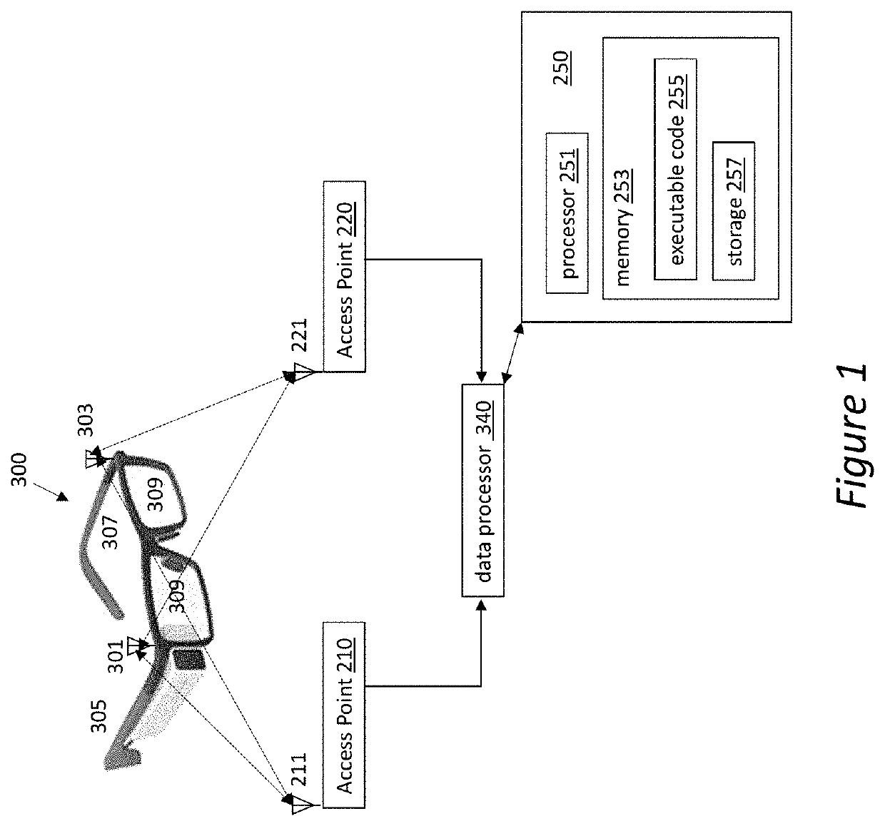
[0064]In this first embodiment of FIG. 1, if the wireless Access Point 210 has a known absolute location (X,Y,Z, or any other coordinate system) with respect to a universal coordinate system, the absolute position and location within a 2-dimensional plane may be determined. This physical location is broadcasted as part of, or in addition to, the multiple frequency RF signal sent from the Access Points 210, 220. Similarly, the other Access Points also may transmit their absolute locations.

[0065]The use of a system employing a single Access Point may be acceptable in certain applications. For example, if one only requires to measure a distance from the Access Point 210 to an HMD 300, a single Access Point would be adequate. However, it is often desired to precisely determine and track the location and orientation of a mobile device, such as HMD 300. In this case, multiple Access Points would be required.

[0066]The present system provides improved location accuracy if there are two Acce...


PUM


Abstract

A tracking system is described having at least two mobile transmitter / receivers (“transceivers”) which sense and respond to at least one tracking transceiver. The signals sent to and received from the mobile transceivers are analyzed to get a distance (range) that each is from the tracking transceiver. This can be converted into a position relative to the mobile transceivers. If there are enough transceivers, and at least one knows its absolute location, the absolute location of the mobile transceivers may be determined. Existing smartphones, cellphones, WI-FI® wireless standard routers, BLUETOOTH® wireless standard devices, and near-field devices that have on-board processors, can be modified to run executable code to implement the current invention. They may communicate using at least one of the modalities for tracking. These may be implemented in tracking the position and orientation of moving devices, such as a head-mounted display for virtual / Augmented Reality, automobiles, packages in a package delivery truck. The system may also be implemented to identify and keep track of the last known location of various objects.

Description

CROSS-REFERENCE TO RELATED APPLICATIONS[0001]This application claims the benefit of and priority to U.S. provisional application No. 62 / 115,954, filed Feb. 13, 2015, entitled “Utilizing Radio Frequency Signals Transmitted by Stationary or Mobile Devices for Accurate and Geographically Broad Tracking of Mobile Devices in the Real World, Augmented Reality or Virtual Reality”, the entirety of which is incorporated by reference herein.BACKGROUND[0002]Field of Invention[0003]The present invention relates to a system for tracking of the position of multiple objects utilizing radio frequency (RF) transmitters, and more specifically to a highly accurate system for tracking the position of multiple objects that may be implemented indoors.[0004]Description of Related Art[0005]Determining the position of an electronic device or object has been a subject of much research since the emergence of RADAR and SONAR. A variety of proximity and position detection schemes exists today. For example, the ...

Claims


Application Information

Patent Timeline
Patent Type & Authority Patents(United States)
IPC IPC(8): G06F3/14G02B27/01G01S5/14G01S5/02G01S5/10G01S19/48G01S5/00
CPCG06F3/14G01S5/0257G01S5/0284G02B27/017G01S5/14G01S5/0072G02B2027/0178G01S19/48G01S5/10G01S5/012G01S2205/02G01S2205/01
Inventor HILL, EDWARD L.BILBREY, BRETTDEFFEBACH, III, HARRY LEEKOMONI, KRENAR
Owner POSITION IMAGING
Why Eureka
Try Eureka