Real-time data aiding for enhanced GPS performance

a technology of real-time data and enhanced gps, which is applied in the field of systems for enhancing global positioning system performance, can solve the problems that incidental uwb emissions onboard an aircraft could interfere with onboard gps navigation equipment, and uwb also happens to be an interference risk to gps, so as to extend gps performance

Inactive Publication Date: 2005-07-21
THE BOEING CO
View PDF13 Cites 94 Cited by
  • Summary
  • Abstract
  • Description
  • Claims
  • Application Information

AI Technical Summary

Benefits of technology

[0016] In accordance with preferred embodiments of the present invention, data from GPS satellites within the field of view of a ground station are retransmitted to LEO satellites, such as Iridium satellites, and cross-linked if necessary before being transmitted to a user. The user is then able to combine the fed-for

Problems solved by technology

Unfortunately, UWB also happens to be an interference risk to GPS since it is partially overlaid on the GPS frequencies.
But even with a re

Method used


Image

  • Real-time data aiding for enhanced GPS performance
  • Real-time data aiding for enhanced GPS performance
  • Real-time data aiding for enhanced GPS performance

Examples


Embodiment Construction

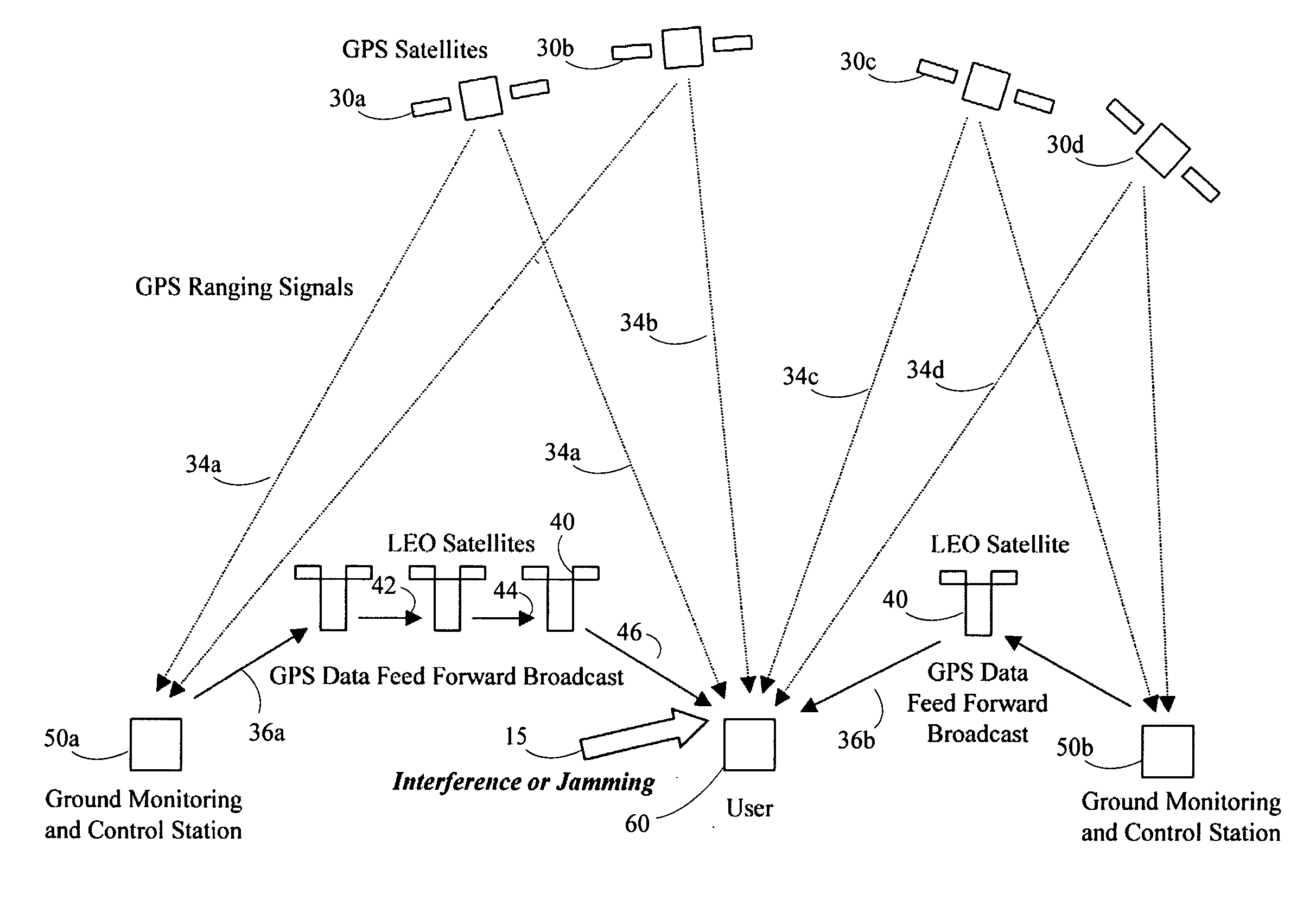
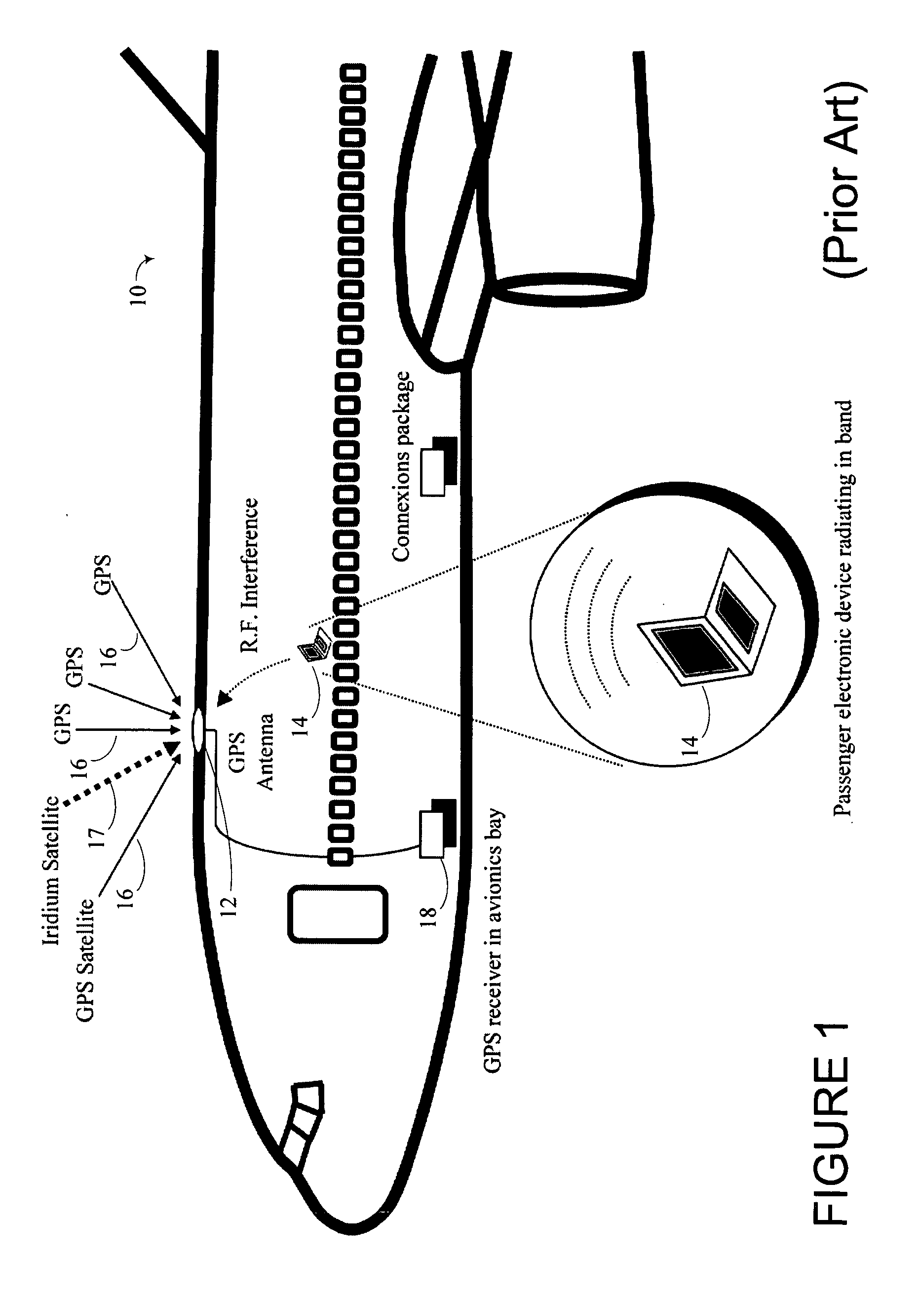
[0035]FIG. 1 shows an example 10 of interference generated within a commercial passenger jet 10 equipped with a GPS antenna 12 and GPS receiver 13. The GPS antenna 12 is capable of receiving GPS signals 16 and LEO satellite signals 17 from those satellites within its field of view.

[0036] If a passenger operates a portable electronic device 14 such as a notebook computer, it is possible that this device 14 could emit interference 15 in the GPS band. Through a number of pathways, this interference 15 can reach the GPS antenna 12 on board the aircraft that is being used for navigation. Depending on its strength, the interference 15 could render the GPS receiver useless, possibly jeopardizing the aircraft and its occupants.

[0037] Three binary codes shift the L1 or L2 carrier phase. The C / A Code (Coarse Acquisition) modulates the L1 carrier phase. The C / A code is a repeating 1 MHz Pseudo Random Noise (PRN) Code. This code modulates the L1 carrier signal, spreading the spectrum over a 1...


PUM


Abstract

Data from GPS satellites within the field of view of a ground station are retransmitted to LEO satellites, such as Iridium satellites, and cross-linked if necessary before being transmitted to a user. The user is then able to combine the fed-forward data with data received directly from GPS satellites in order to resolve errors due to interference or jamming. Iridium and data aiding thus provides a means for extending GPS performance under a variety of data-impaired conditions because it can provide certain aiding information over its data link in real time.

Description

PRIORITY CLAIM [0001] This application claims priority to provisional application 60 / 536,788 filed on Jan. 15, 2004 and is incorporated herein by reference.FIELD OF THE INVENTION [0002] This invention relates generally to systems for enhancing global positioning system performance. BACKGROUND OF THE INVENTION [0003] GPS, or Global Positioning System, is funded by and controlled by the U. S. Department of Defense (DOD). While there are many thousands of civil users of GPS worldwide, the system was designed for and is operated by the U. S. military. GPS provides specially coded satellite signals that can be processed in a GPS receiver, enabling the receiver to compute position, velocity, and time. Four GPS satellite signals are used to compute positions in three dimensions and the time offset in the receiver clock. The GPS satellite is one of a constellation of approximately twenty-four GPS satellites operated by United States Department of Defense orbiting the Earth approximately twi...

Claims


Application Information

Patent Timeline
IPC IPC(8): G01S19/48G01S1/00G01S5/00
CPCG01S19/06H04K3/90H04K3/255G01S19/21
Inventor COHEN, CLARKFERRELL, BARTGUTT, GREGWHELAN, DAVID
Owner THE BOEING CO
Why Eureka
Try Eureka