Position information management system

a technology of information management system and position information, applied in the field of position information management system, can solve problems such as failure to operate in a location, and achieve the effect of high serviceability

Inactive Publication Date: 2006-02-09
FUJITSU LTD
View PDF35 Cites 38 Cited by
  • Summary
  • Abstract
  • Description
  • Claims
  • Application Information

AI Technical Summary

Benefits of technology

[0011] An object of the present invention is to provide a pos

Problems solved by technology

Therefore, the system has the disadvantage of failing to operate in a loc

Method used


Image

  • Position information management system
  • Position information management system
  • Position information management system

Examples


Embodiment Construction

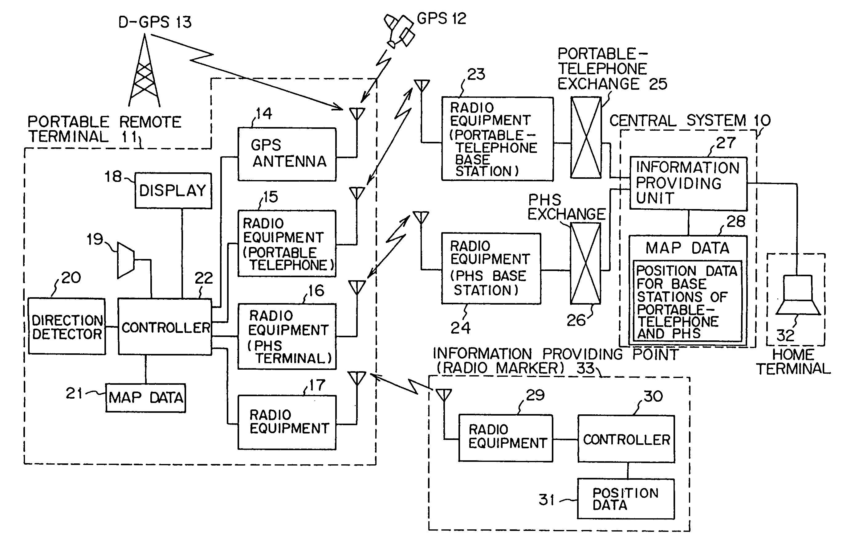
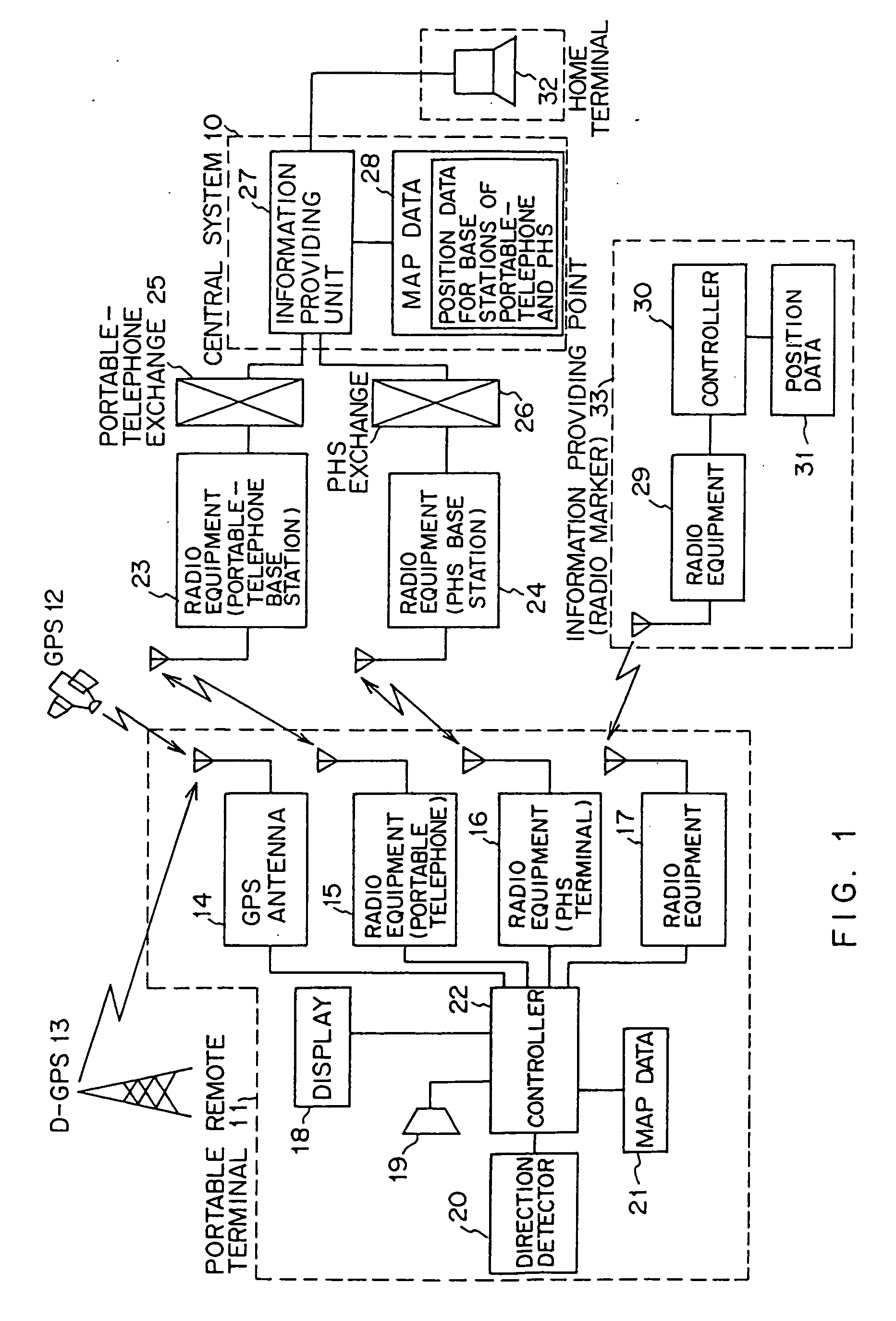
[0030]FIG. 1 is a block diagram showing the system architecture of a position information management system embodying the present invention.

[0031] The system of the present invention comprises a central system 10 which manages information in unified fashion, a portable remote terminal 11 which is carried by a person, a satellite 12 which serves for a GPS, a radio wave transmission tower 13 which serves for a D-GPS (Differential GPS), and an information offer point (radio marker) 33 which determines the position of the portable terminal 11 by radio waves.

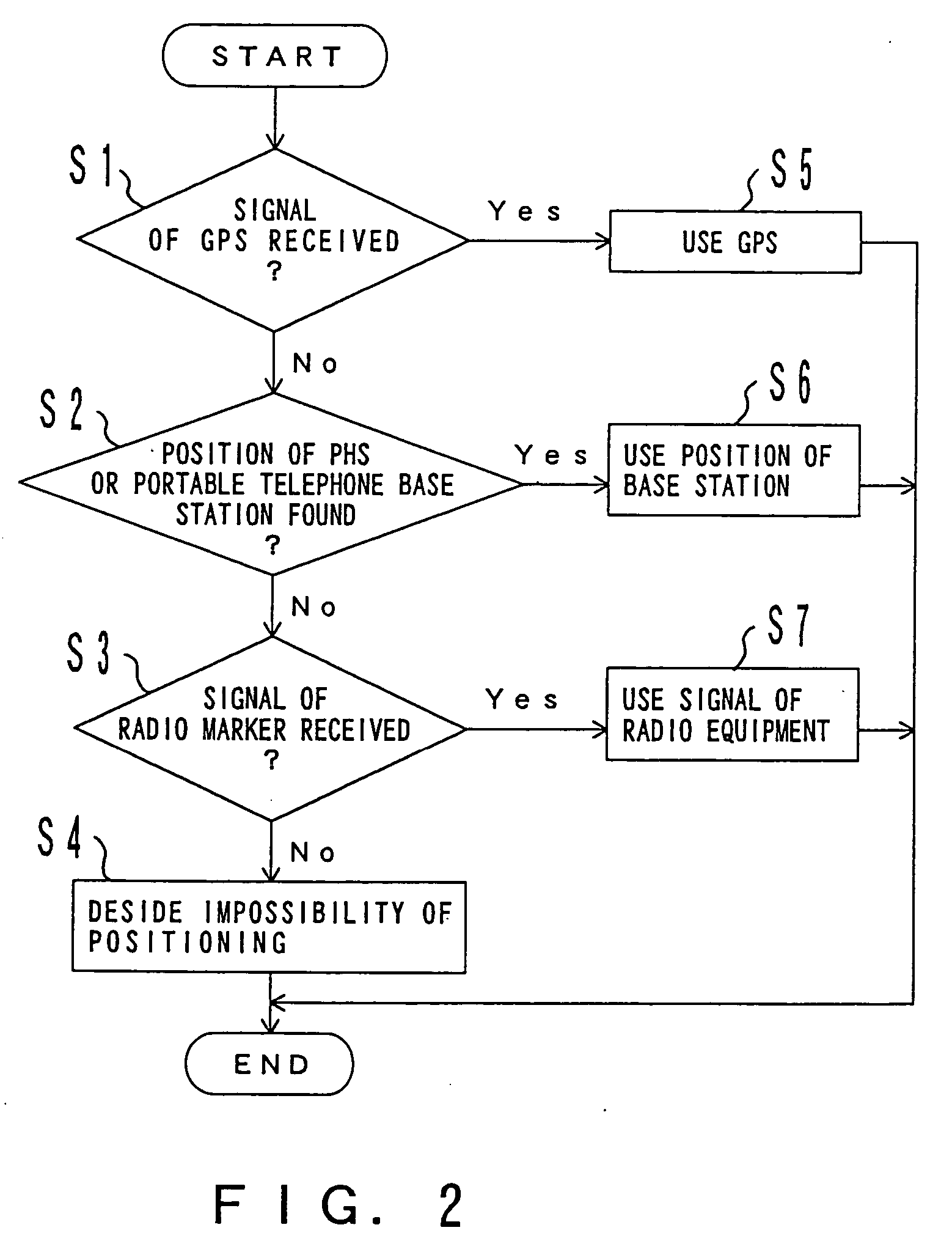
[0032] The portable terminal 11 includes the respective receivers of a GPS antenna 14, radio equipment 15 for a portable telephone, radio equipment 16 for a “PHS”, and radio equipment 17 for receiving radio waves from the radio marker 33. The respective receivers receive radio waves from corresponding radio-wave transmission stations, and deliver them to a controller 22. (Incidentally, the initials “PHS” stand for “Personal Handy-p...


PUM


Abstract

A position information management system in which a portable remote terminal includes a plurality of kinds of positioning means for positioning based on a GPS, positioning based on a portable-telephone or PHS base station, positioning based on a radio marker, and independent positioning based on a direction detector, so that the holder of the portable remote terminal can be navigated anywhere. The holder of the portable remote terminal can know the position of a third party similarly holding such a portable remote terminal, by inquiring of a central system, and he/she can supervise, for example, the action of an old person, a child, or a skier in a skiing area. Further, only the map data of a district which is often used by the holder is stored in the portable remote terminal. In this regard, when the holder is in a district not contained within the retained map data, he/she downloads corresponding map data from the central system and uses the downloaded map data.

Description

BACKGROUND OF THE INVENTION [0001] 1. Field of the Invention [0002] The present invention relates to a position information management system, and more particularly to a system for managing the position information of pedestrians. [0003] 2. Description of the Related Art [0004] Nowadays, a car navigation system wherein a terminal is mounted in an automobile so as to display the current position of the automobile has been put into practical use and put on the market. According to the car navigation system, anybody can reach a destination without getting lost even in an area which he / she visits for the first time, because the map of his / her surroundings is displayed with the current position. [0005] The car navigation system executes the processing of receiving radio waves from satellites so as to acquire the current position in terms of a latitude and a longitude, and reading out map information which contains the acquired latitude and longitude, from a memory device. [0006] Such car...

Claims


Application Information

Patent Timeline
IPC IPC(8): H04Q7/20G01S5/00G01S5/02G01S5/14G01S19/13G01S19/48H04W4/20
CPCG01C21/005G01S5/0027G01S5/0081G01S5/02H04L67/18G01S19/13G01S19/48G01S2205/008H04W4/20G01S5/0284H04L67/52G01S2205/06
Inventor HASHIMOTO, KEN
Owner FUJITSU LTD
Why Eureka
Try Eureka