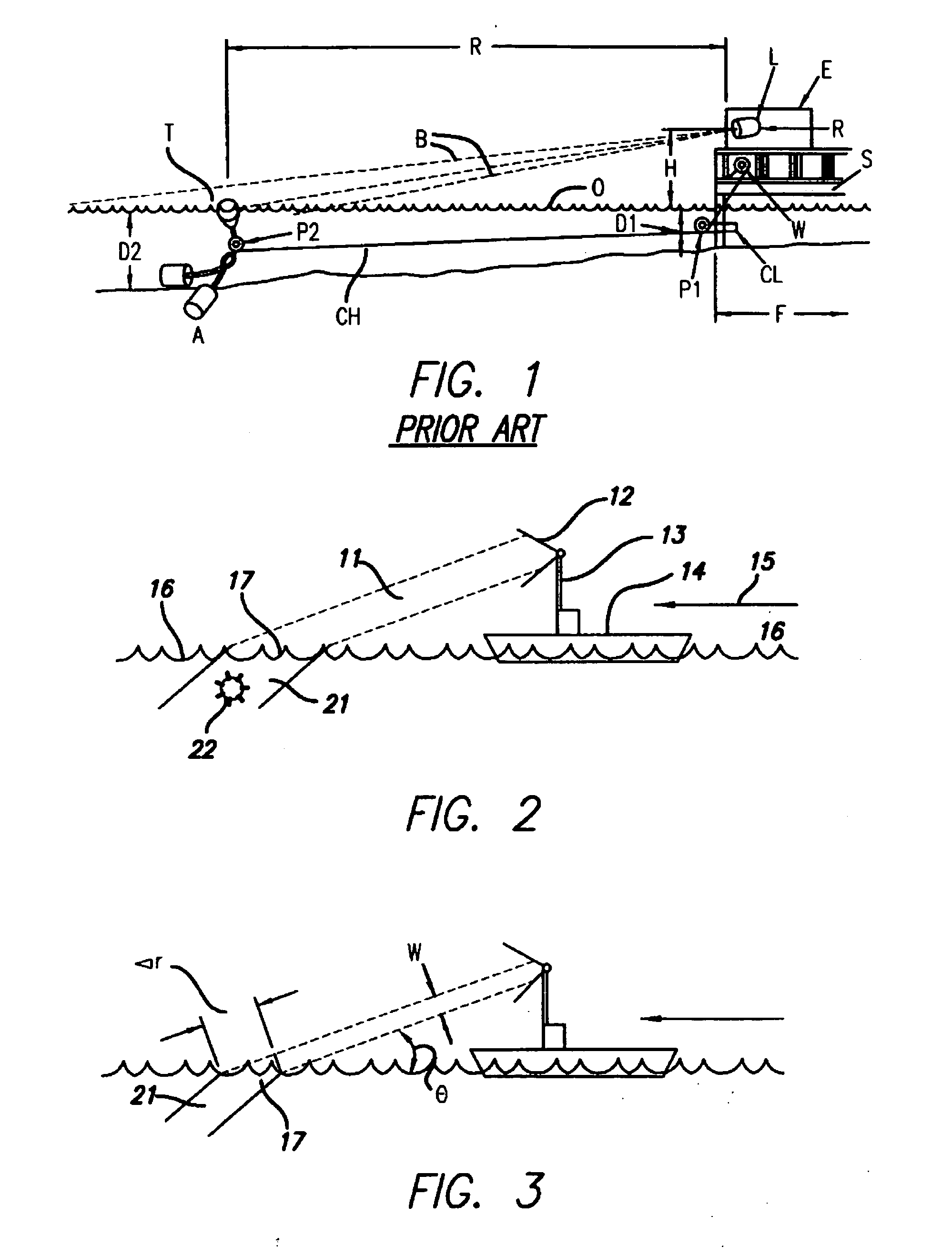
Shallow-angle marine observation systems—A particular difficulty of all marine observational systems, even visual systems, is the problem of interference by the water surface.
Another noteworthy problem with such systems is the limited range of known apparatus and methods.
In the past, short range has been seen as essentially an inherent limitation of mast-mounted or other only-slightly-elevated equipment.
There was no suggestion of an entirely practical implementation for such an idea.
Thus the prior art fails to deal incisively, or effectively, with the previously mentioned problems of interference arising from
surface reflection.
A separate
system for such purposes, however, is costly and occupies significant space in the
command center of a water craft.
Aircraft-carrier operations—In addition to detection of floating and airborne obstacles (e. g. mines and other hazards), another marine-related problem that would benefit from
visibility aids is that of aircraft-carrier landing.
This problem is particularly acute at night, and in
fog or other turbid-
atmosphere conditions.
The difficulty of such operations is compounded by the high speeds involved, the fact that not only the aircraft but also the carrier is in motion.
A further complication sometimes is the need for a degree of discreet or covert character in the traffic.
Radio guidance may be of limited practicality in such circumstances.
In that system, typically imaging is limited to detection from altitudes of at least 160 m (500 feet) and looking straight down into the water with the center of the probe beam.
These concerns have not been adequately addressed with existing airborne LIDAR systems.
Both the shapes and the positions of submerged objects are distorted by uncorrelated refractions of different parts of the probe / return beam, due to irregularity of the water surface.
Uncertainties in coverage: Current systems also provide inadequate information about the fraction of the undersea environment that is actually being screened.
The root problem is that wave focusing and defocusing of rays from a LIDAR system cause gaps in the coverage at different depths.
That is to say, inherently certain volumes of water receive and reflect very little light, which means that objects within those volumes cannot be detected.
The difficulty here is that existing systems cannot accurately estimate the extent of these effects at different depths, and therefore cannot generate good area-coverage estimates at those depths.
There is no reliable measurement of how well—in particular, how uniformly—the system is illuminating and imaging each layer of water.
This model is hard to validate—and the estimate of
sea state may or may not be accurate or timely.
Errors in the sea-state estimate force present systems to make either too many passes over the same area, which results in poor effective area-coverage rates, or too few passes, which may leave the area inadequately sampled and so unsafe for ship transit.
No effort heretofore has been directed to adapting this technology to either surveillance of the sea from either aircraft or
surface water craft.
These forms of the method therefore rely heavily upon the essentially stationary character of the observing platform, and are accordingly too slow for use with fixed-wing surveillance aircraft.
Since the method of the '493 patent is able to determine only bearing, not range—from any single observation apparatus—image reconstruction is impossible from such a single apparatus.
Although the requirement of a long baseline is acceptable for waterborne observation platforms that are very large, and so intrinsically can provide a long baseline, such a requirement is undesirable for airborne surveillance as it calls for a very large aircraft operating at very low altitudes—or alternatively introduces the additional complications of plural aircraft conducting a coordinated surveillance.
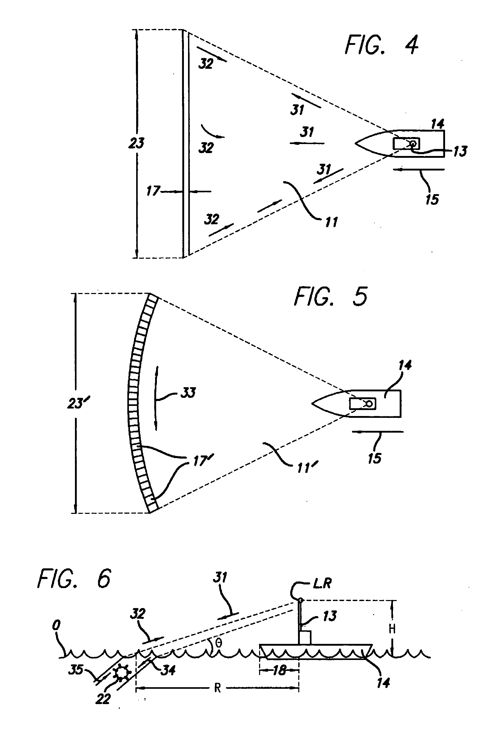
Limitations due to fan-beam properties: Yet another obstacle to optimum practice of the innovations set forth in the U.S. Pat. No. 5,467,122 patent is the difficulty of obtaining uniform
energy distribution and consistent
divergence angle in the fan beam.
In practice a high-energy
pulsed laser beam is neither stable in size and position nor uniform in
energy distribution, across the cross-section of the beam.
Even a stable
laser beam of uniform
energy distribution, however, when thus spread to form a fan-
shaped beam is nonuniform in intensity when it reaches the water surface (or any object plane)—due to long propagation distances required to reach the water at the extreme ends of the “fan”.
This
delay, however, is wholly geometrical and therefore readily compensated in
software; the accompanying brightness reduction cannot be resolved so easily.
In practice a rather complicated and unknown added attenuation is likely to occur in those regions.
Application of that factor in increased
gain or brightness may be expected to overcompensate with respect to brightness of glints—but this is unavoidable in view of the different reflection mechanisms involved, as explained above.
Because a
gain-control approach would fail to equalize SNR across the fan-beam track, however, such an approach—although within the scope of the invention—is unappealding.
In other words, information at the wings of the data array would be chronically both less clear and less reliable than information at the center.
Although extremely helpful, this system does not truly flatten the energy distribution along the intersection of the fan beam with the water surface, even in theory—and even for the volume
backscatter as distinguished from the glints.
When the above-mentioned beam instabilities and nonuniformities are taken into consideration, the problem is far more severe.
This drift degrades the operating assumptions behind that device, and correspondingly disrupts its performance in equalizing energy at the limbs vs. the center of the fan.
The distributional drift enormously complicates any effort to systematically compensate for known departures from often-assumed “top-hat” or
Gaussian energy distributions in the beam cross-section.
Trying to correct for a constantly changing, unknown, high-power energy profile that is gone a
nanosecond after it starts is a virtual impossibility with present-day technology—and stabilization of a high-power
laser against both positional and distributional drifts is essentially prohibitive.
This is challenging.
As can now be seen, the related art remains subject to significant problems.

