Visual inputs for navigation

a navigation system and input interface technology, applied in surveying, navigation, navigation instruments, etc., can solve the problems of inability to fully understand the voice interface, inability to provide navigation information, etc., to achieve enhanced performance

Inactive Publication Date: 2008-02-14
INTEL CORP
View PDF35 Cites 43 Cited by
  • Summary
  • Abstract
  • Description
  • Claims
  • Application Information

AI Technical Summary

Benefits of technology

[0012] In some embodiments of the present invention, techniques for using such devices as an interface to a mobile navigation system recognize and deal with all the above-noted issues. According to aspects of the invention, these technical difficulties have been overcome, wherein an interface is provided in which optical images acquired by cellular telephone devices serve as inputs to a mobile navigation system. This is achieved transparently to the user. In some embodiments, no modification of the cellular telephone devices is necessary. In other embodiments, performance is enhanced by downloading and installing specialized programs in the cellular telephone devices that are adapted to the mobile navigation system. Optical images may be uploaded automatically or interactively, and can be processed remotely, generally without further user interaction.

Problems solved by technology

Conventional inputs to navigation systems have been a limiting factor for mobile users.
Mobile device keyboards are frustrating for unpracticed users.
However, the vocal interface may require extensive training, or may be rendered inaccurate by background noise, which is common in vehicular and urban pedestrian environments.
Thus, one seeking to develop improved uses for cellular telephone devices is confronted with a lack of a general platform that supports the cellular telephones of different service providers in different areas of the country, and must deal with co-existing incompatible communications protocols.
These may have some integral optical capabilities, or may accept input from an external optical device, but they have limited processing capabilities and memory capacity.

Method used


Image

  • Visual inputs for navigation
  • Visual inputs for navigation
  • Visual inputs for navigation

Examples


embodiment 1

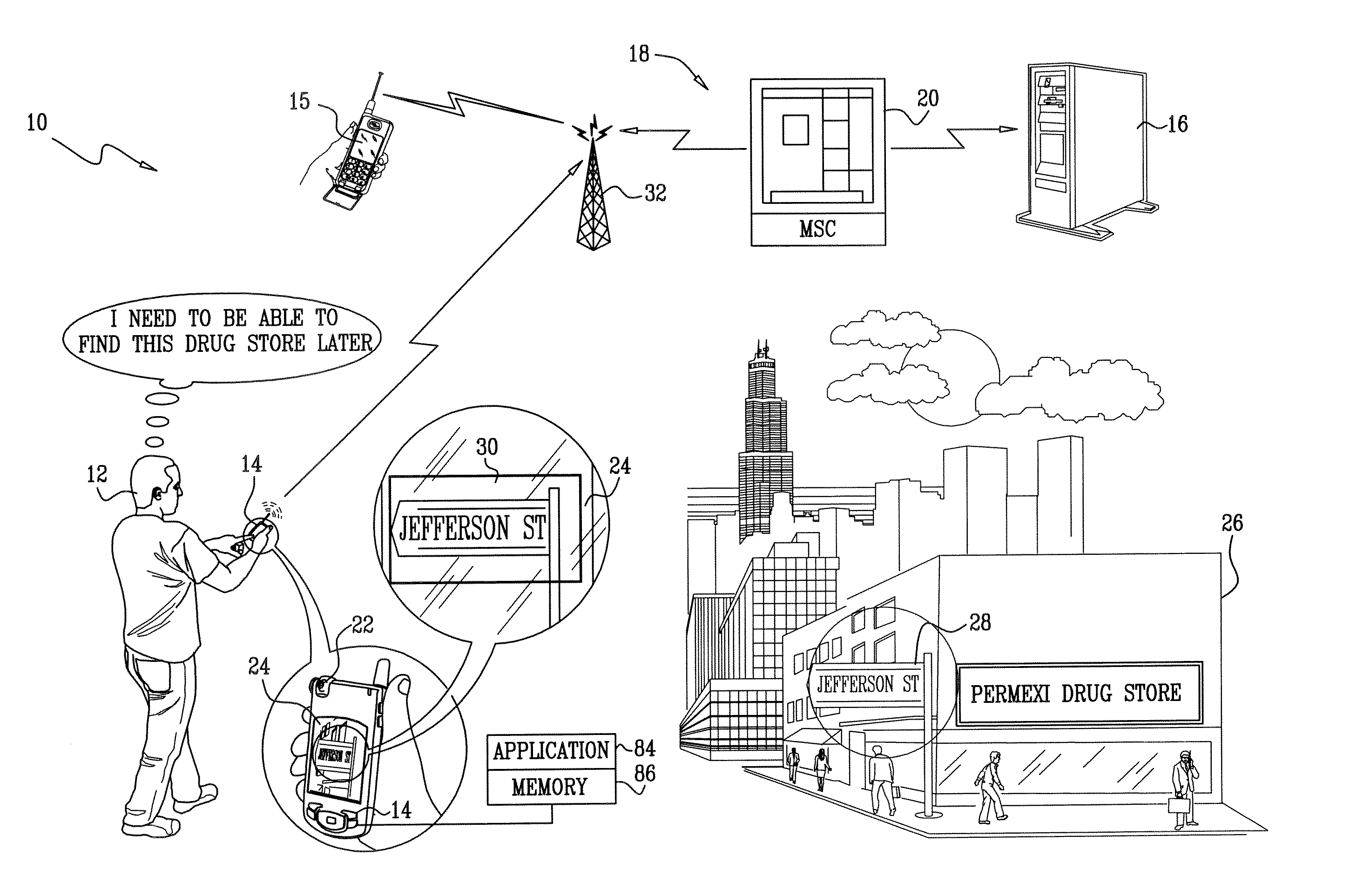
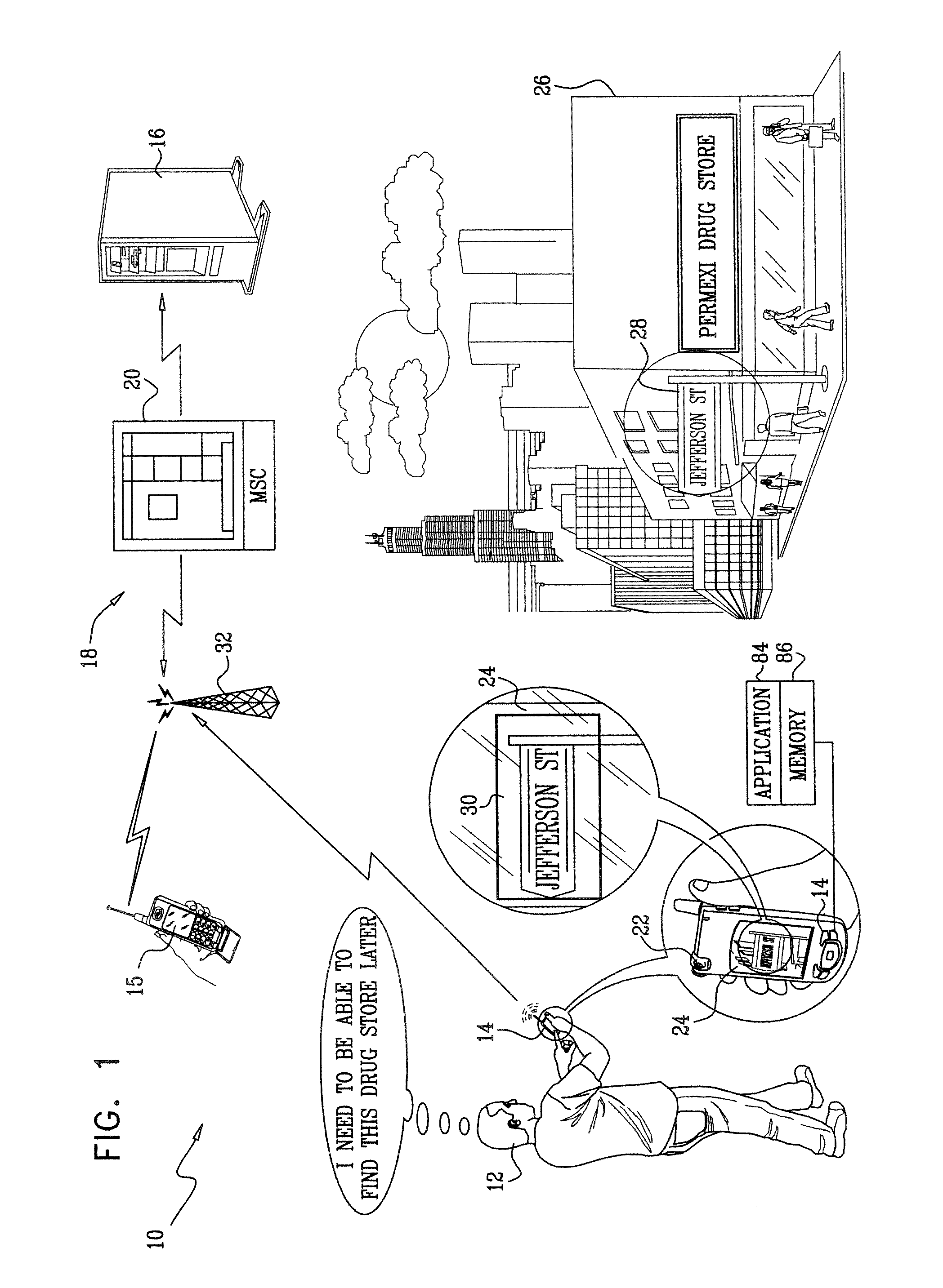
[0029] Turning now to the drawings, reference is initially made to FIG. 1, which is a simplified pictorial illustration of a real-time navigation system 10 constructed and operative in accordance with a disclosed embodiment of the invention. In this illustration, a pedestrian 12, using a wireless device 14, communicates with a map server 16 via a commercial wireless telephone network 18. The network 18 may include conventional traffic-handling elements, for example, a mobile switching center 20 (MSC), and is capable of processing data calls using known communications protocols. The mobile switching center 20 is linked to the map server 16 in any suitable way, for example via the public switched telephone network (PSTN), a private communications network, or via the Internet.

[0030] The wireless device 14 is typically a handheld cellular telephone, having an integral photographic camera 22. A suitable device for use as the wireless device 14 is the Nokia® model N73 cellular telephone,...

embodiment 2

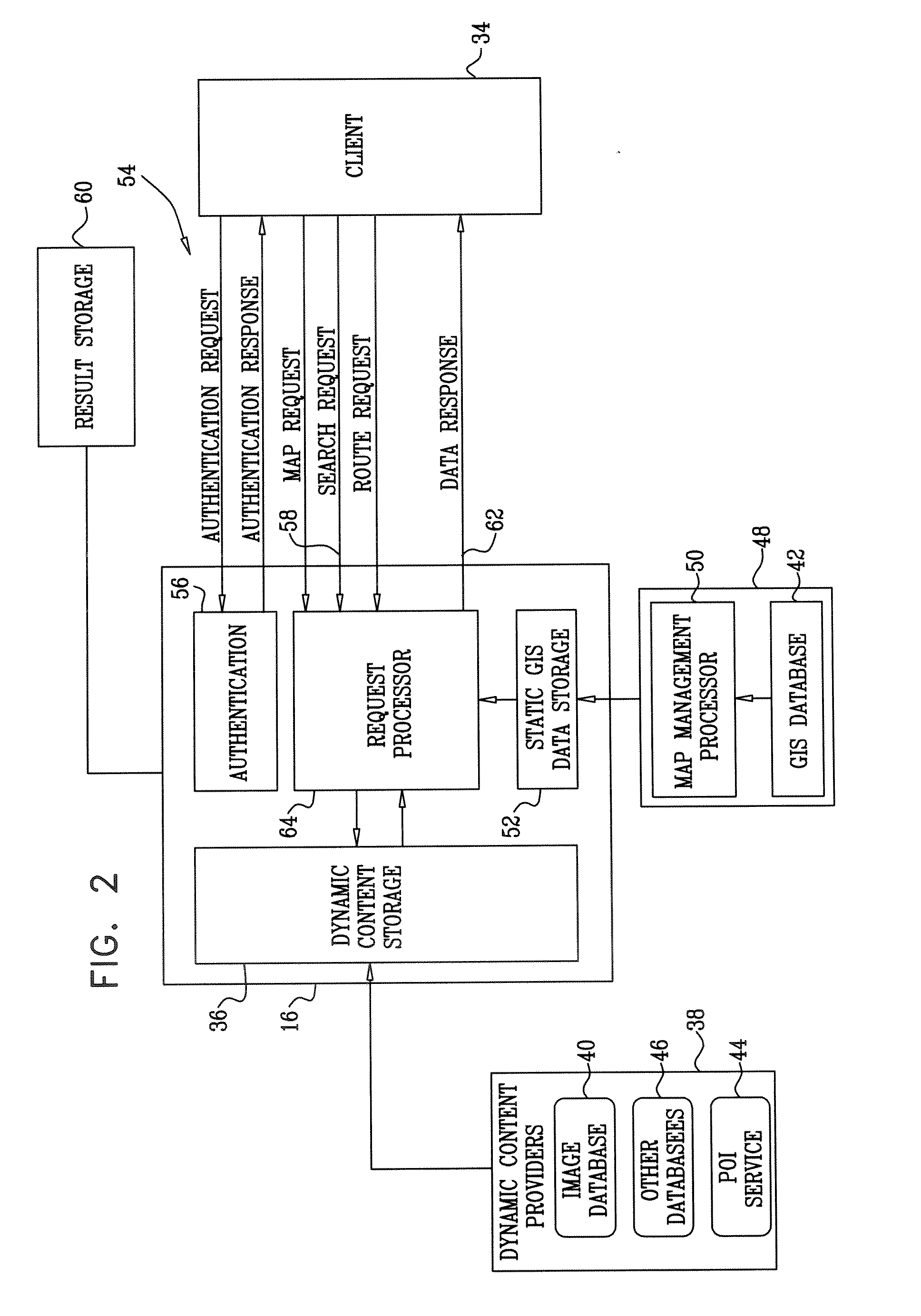
[0052] Irrespective of whether a visual input to the wireless device is stored within an application, or as MMS-compliant data, address recognition is still required. In Embodiment 1, this process was conducted in the map server 16 (FIG. 1). In this embodiment, OCR and language post-processing are performed on the client device.

[0053] Reference is now made to FIG. 4, which is a pictorial diagram of a wireless device 90 that is constructed and operative for generating visual input for navigation in accordance with a disclosed embodiment of the invention. The wireless device 90 is similar to the wireless device 14 (FIG. 1), but has enhanced capabilities. An OCR engine 92 and optionally a language processor 94 now provide the functionality of the OCR engine 74 and language processor 76 (FIG. 3), respectively, enabling address recognition of a visual image to be performed by the wireless device 90, in which case the OCR engine 74 and language processor 76 in the map server 16 (FIG. 2) ...


PUM


Abstract

An interface is provided to a mobile navigation system in which an optical image of a point-of-interest acquired by cellular telephone devices is an input to the system. Textual and optionally other location information is extracted from the image, and used by the navigation system to identify coordinates and vectors relating to the point-of-interest. The results are stored and may be subsequently recalled to provide mapping and routing information to the cellular telephone device, whose position relative to the point-of-interest may have changed. Optical images may be uploaded from telephone device to the navigation system automatically or interactively, and can be processed remotely, generally without further user interaction.

Description

CROSS-REFERENCE TO RELATED APPLICATIONS [0001] This application claims the benefit of U.S. Provisional Application 60 / 776,579, filed Feb. 23, 2006, which is herein incorporated by reference.BACKGROUND OF THE INVENTION [0002] 1. Field of the Invention [0003] This invention relates to methods and mobile systems for providing navigation and location information. More particularly, this invention relates to input interfaces for navigation and location systems. [0004] 2. Description of the Related Art TABLE 1Acronyms and AbbreviationsAPIApplication Programing InterfaceASCIIAmerican Standard Code for InformationInterchangeGPSGlobal Positioning SystemHTTPHypertext Transfer ProtocolMMSMultimedia Messaging SystemMSCMobile Switching CenterOCROptical Character RecognitionPDAPersonal Digital AssistantPOIPoint-of-interestPSTNPublic Switched Telephone NetworkSNMPSimple Network Management ProtocolSOAPSimple Object Access ProtocolTCP / IPTransmission Control Protocol / InternetProtocol[0005] A variety...

Claims


Application Information

Patent Timeline
Patent Type & Authority Applications(United States)
IPC IPC(8): G01C21/00
CPCG01C21/3679G01C21/20
Inventor GAD, ASSAF
Owner INTEL CORP
Why Eureka
Try Eureka