Method for correcting ionosphere error, and system and method for determining precision orbit using the same

a technology of ionosphere and error correction, which is applied in the field of method for correcting ionosphere error and system and method for precisely determining orbit, can solve the problems of large error value of ionosphere model, delaying the gps signal, and reducing the accuracy of determining orbit in the navigation system, so as to achieve less data capacity, reduce the effect of ionosphere errors in observation data, and reduce the effect of delay

Inactive Publication Date: 2009-04-09
ELECTRONICS & TELECOMM RES INST
View PDF1 Cites 32 Cited by
  • Summary
  • Abstract
  • Description
  • Claims
  • Application Information

AI Technical Summary

Benefits of technology

[0012]According to the present invention, ionosphere errors in observation data can be effectively eliminated, and an orbit can be precisely determined using the ionosphere errors eliminated observation data. Therefore, the present invention can be applied to precise geodetic survey and a navigation system using a single frequency.
[0013]Although average data of carrier phase data and pseudorange data is used to obtain precise ionosphere error, an orbit is accurately determined and a geodetic survey is precisely performed without calculating an integer ambiguity according to the present invention because a distance difference between averaged observation data at every observation time, and it can be calculated in high speed with less data capacity even in an on-board system.
[0014]By directly correcting ionosphere error in carrier phase data, it is possible to use precisely calculated observation data and noise free carrier phase data. Accordingly, the orbit is more accurately determined and the geodetic survey is more precisely performed by L1 carrier phase correction compared to a geodetic survey and an orbit determination using pseudorange with dual frequency. Furthermore, the ionosphere error can be eliminated without modifying source codes related to precise geodetic survey and to precise orbit determination.

Problems solved by technology

Such a GPS signal is delayed while passing the atmosphere due to an ionosphere error, a troposphere error, and a multipath error.
These errors degrade the accuracy to determine an orbit in a navigation system or a precise geodetic survey.
The method of using the ionosphere model produces large error values when the elevation angle of GPS satellite is lowered.
The method of using the ionosphere model generally produces inaccurate data compared to the method of using the observed data values.
Such an inaccurate observation data degrades the accuracy of an orbit.
Inaccurate integer ambiguity degrades the precision of the observed data, and estimation of integer ambiguity is very annoying process in software view.

Method used


Image

  • Method for correcting ionosphere error, and system and method for determining precision orbit using the same
  • Method for correcting ionosphere error, and system and method for determining precision orbit using the same
  • Method for correcting ionosphere error, and system and method for determining precision orbit using the same

Examples


Embodiment Construction

[0020]Other objects and aspects of the invention will become apparent from the following description of the embodiments with reference to the accompanying drawings, which is set forth herein after.

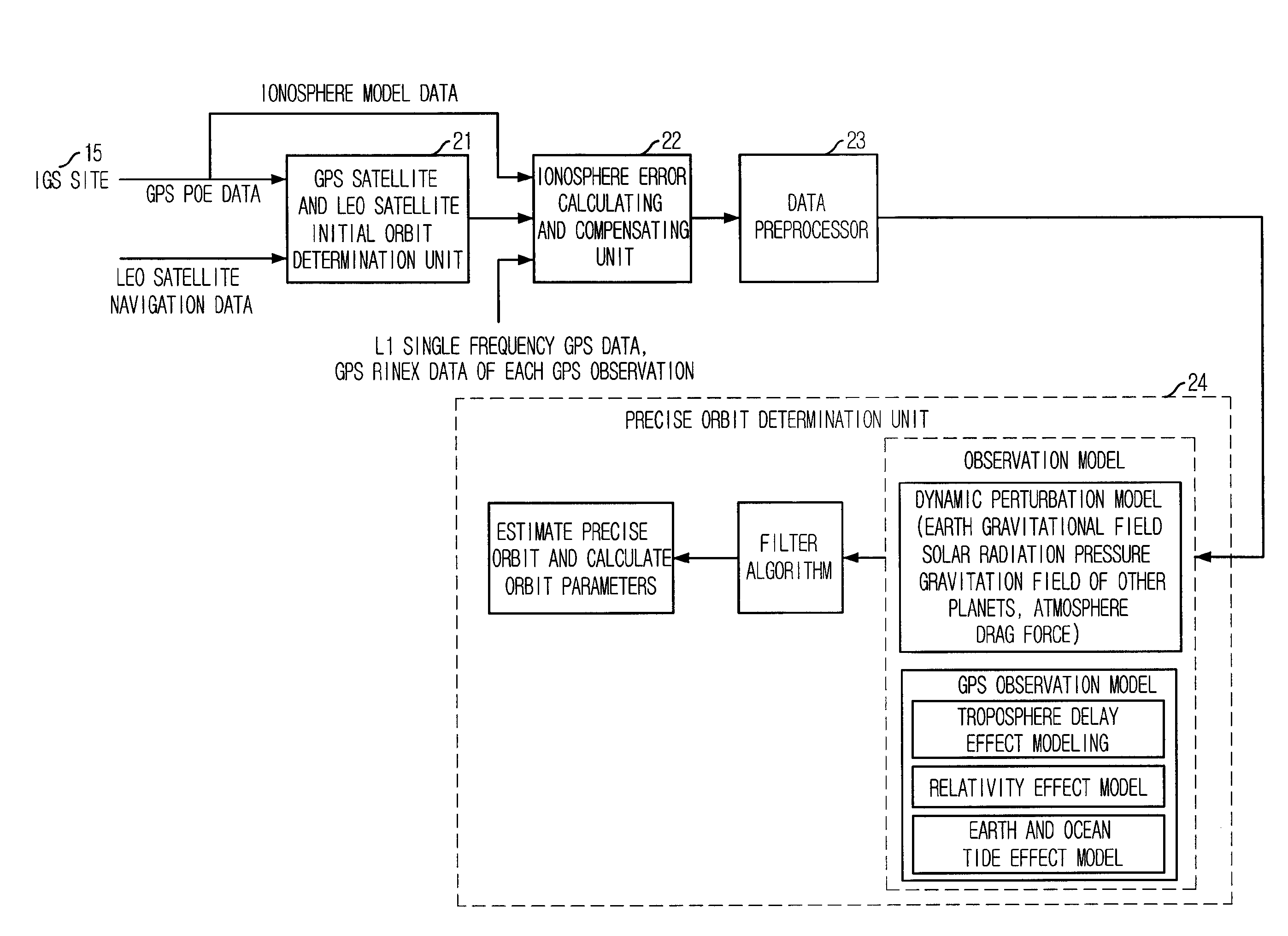
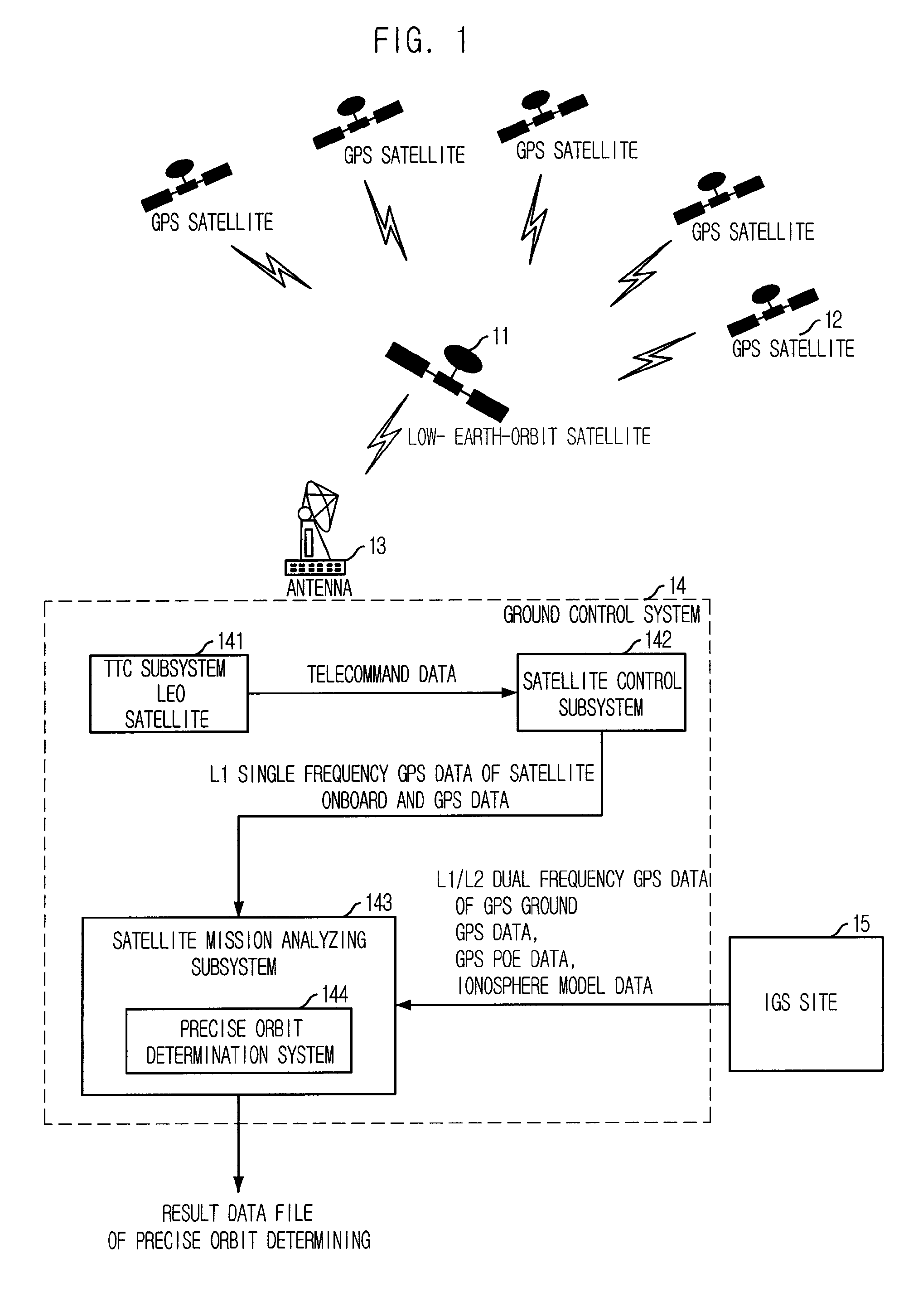
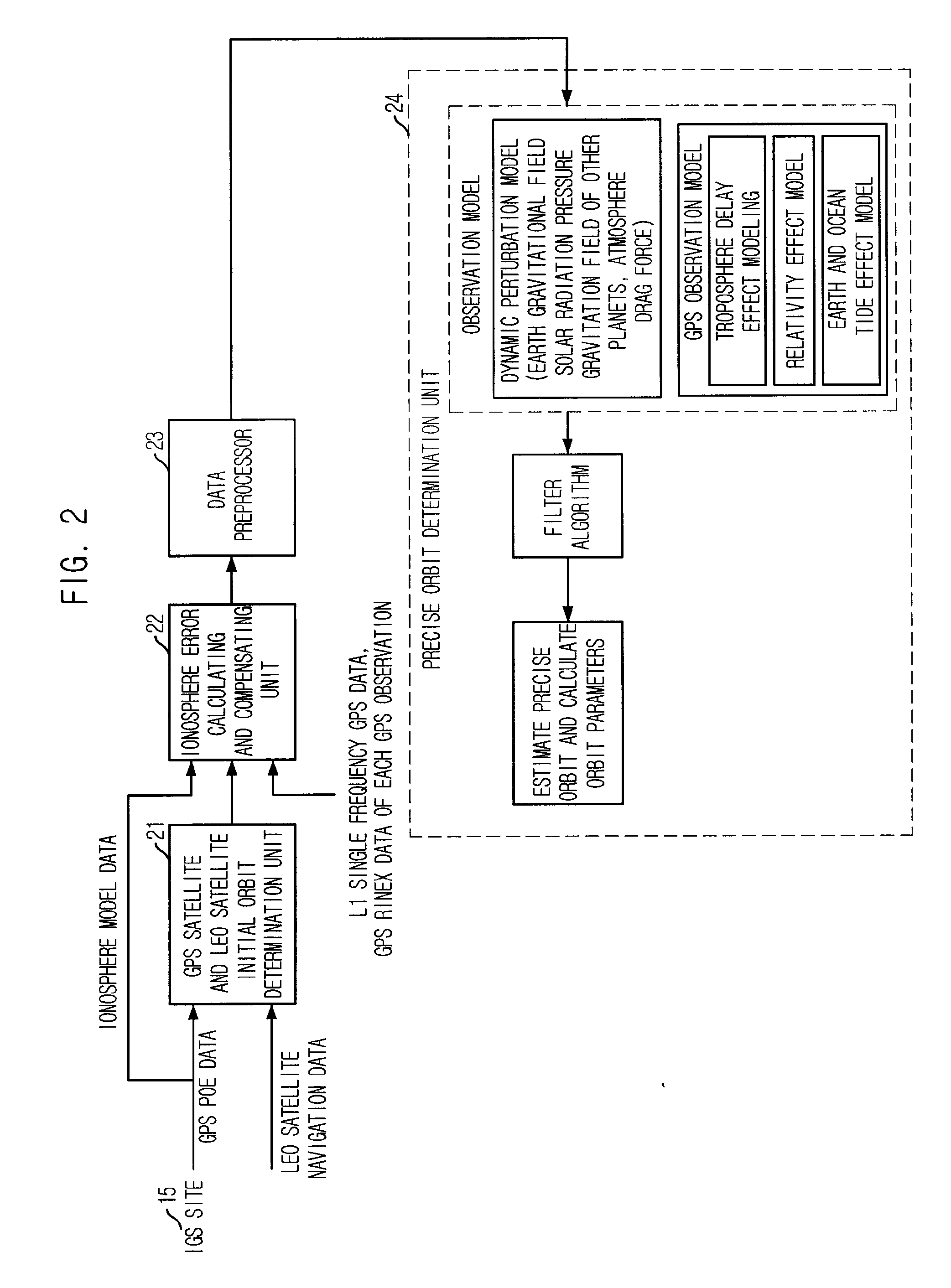
[0021]FIG. 1 is a block diagram illustrating a control system of LEO satellites where the present invention is applied.

[0022]As shown in FIG. 1, the ground control system includes: a LEO satellite 11 receiving GPS data from a plurality of GPS satellites 12; GPS observation stations (not shown) distributed world-widely; an IGS site 15 for gathering data from the GPS observation stations and determining a precise ephemeris of GPS satellite; and a control system 14 for monitoring states of LEO satellite 11 and controlling the LEO satellite 11 by collecting and transmitting remote measuring data from / to the LEO satellite 11 through an antenna 13.

[0023]Hereinafter, operation of the control system will be described.

[0024]The GPS data received at an on-board of a LEO satellite is transmitted from...


PUM


Abstract

Provided is a method of correcting an ionosphere error, a system of a precise orbit determination using the same and a method thereof. The method includes the steps of: a) determining a time of a highest elevation angle of a GPS satellite per one pass of each GPS satellite received at a LEO satellite or a receiver on a ground; b) determining a minimum total electron content found from an ionosphere model of the determined time per one pass of each GPS satellite; c) determining a total electron content directly calculated from the LEO satellite or a single frequency GPS data; d) determining an ionosphere error value of a single frequency GPS data by combining the minimum total electron content and the directly calculated total electron content; and e) correcting pseudorange data or carrier phase data based on the determined ionosphere error value.

Description

TECHNICAL FIELD[0001]The present invention relates to a method for correcting an ionosphere error, and a system and a method for precisely determining an orbit using the same; and more particular, to a method for correcting an ionosphere error caused by using a single frequency, a system for precisely determining an orbit using observation data measured through the ionosphere error correcting method, and a method thereof.BACKGROUND ART[0002]A global positioning system (GPS) has been used in various fields such as a geodetic survey, a survey, a scientific observation and a time synchronization. A GPS signal has a 1575.42 MHz of L1 frequency and a 1227.6 MHz of L2 frequency. Such a GPS signal is delayed while passing the atmosphere due to an ionosphere error, a troposphere error, and a multipath error. These errors degrade the accuracy to determine an orbit in a navigation system or a precise geodetic survey. After releasing a S.A. effect at May 2005, it is possible to eliminate the i...

Claims


Application Information

Patent Timeline
Patent Type & Authority Applications(United States)
IPC IPC(8): G01S5/14G01S19/07
CPCG01S19/07G01S19/072G01S5/14G01S19/06
Inventor HWANG, YOO-LALEE, BYOUNG-SUNKIM, JAE-HOON
Owner ELECTRONICS & TELECOMM RES INST
Why Eureka
Try Eureka