
Signal processing techniques for improving the sensitivity of GPS receivers

Inactive Publication Date: 2010-01-28
ETHERWHERE CORP
View PDF3 Cites 23 Cited by
  • Summary
  • Abstract
  • Description
  • Claims
  • Application Information

AI Technical Summary

Benefits of technology

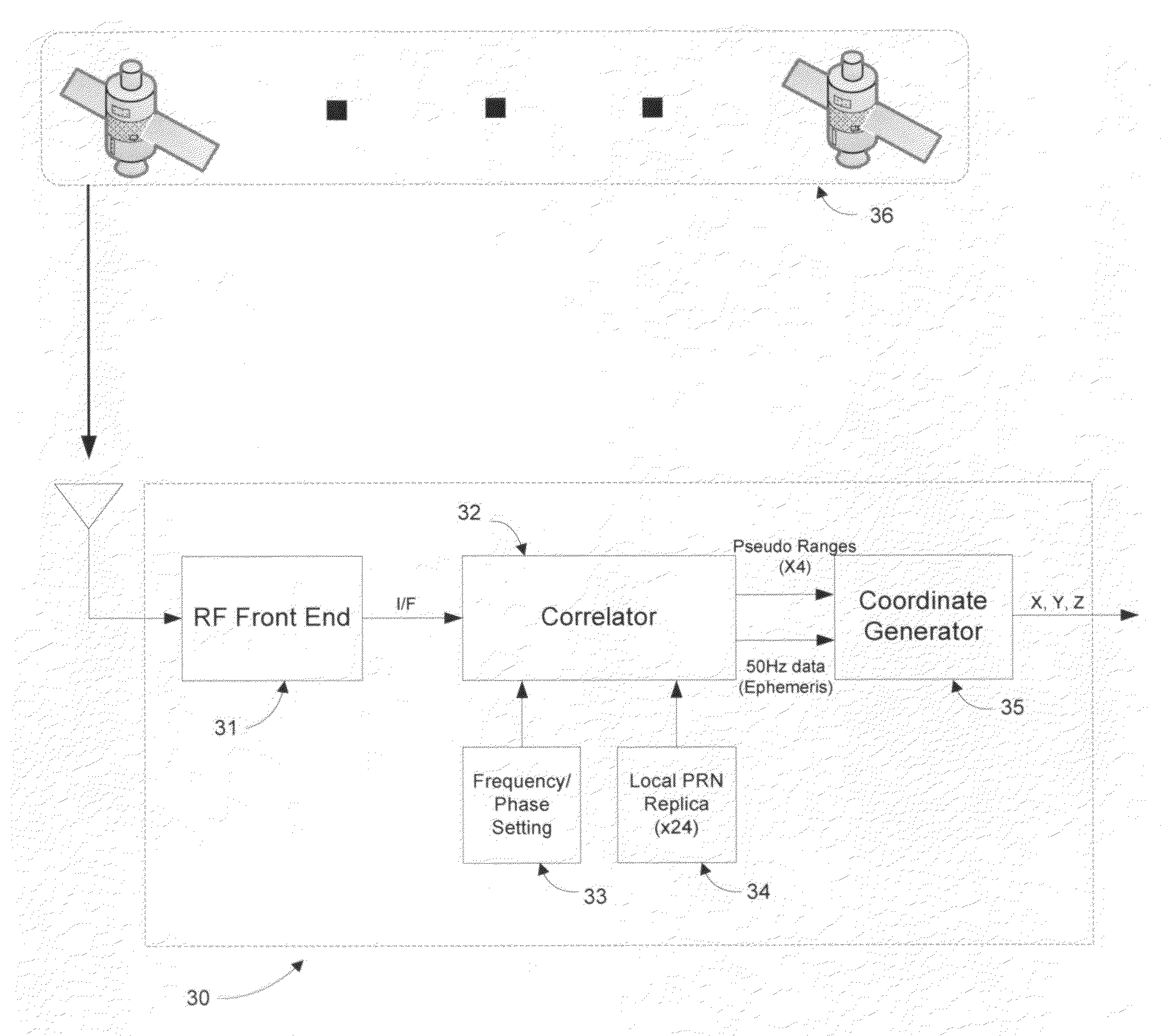
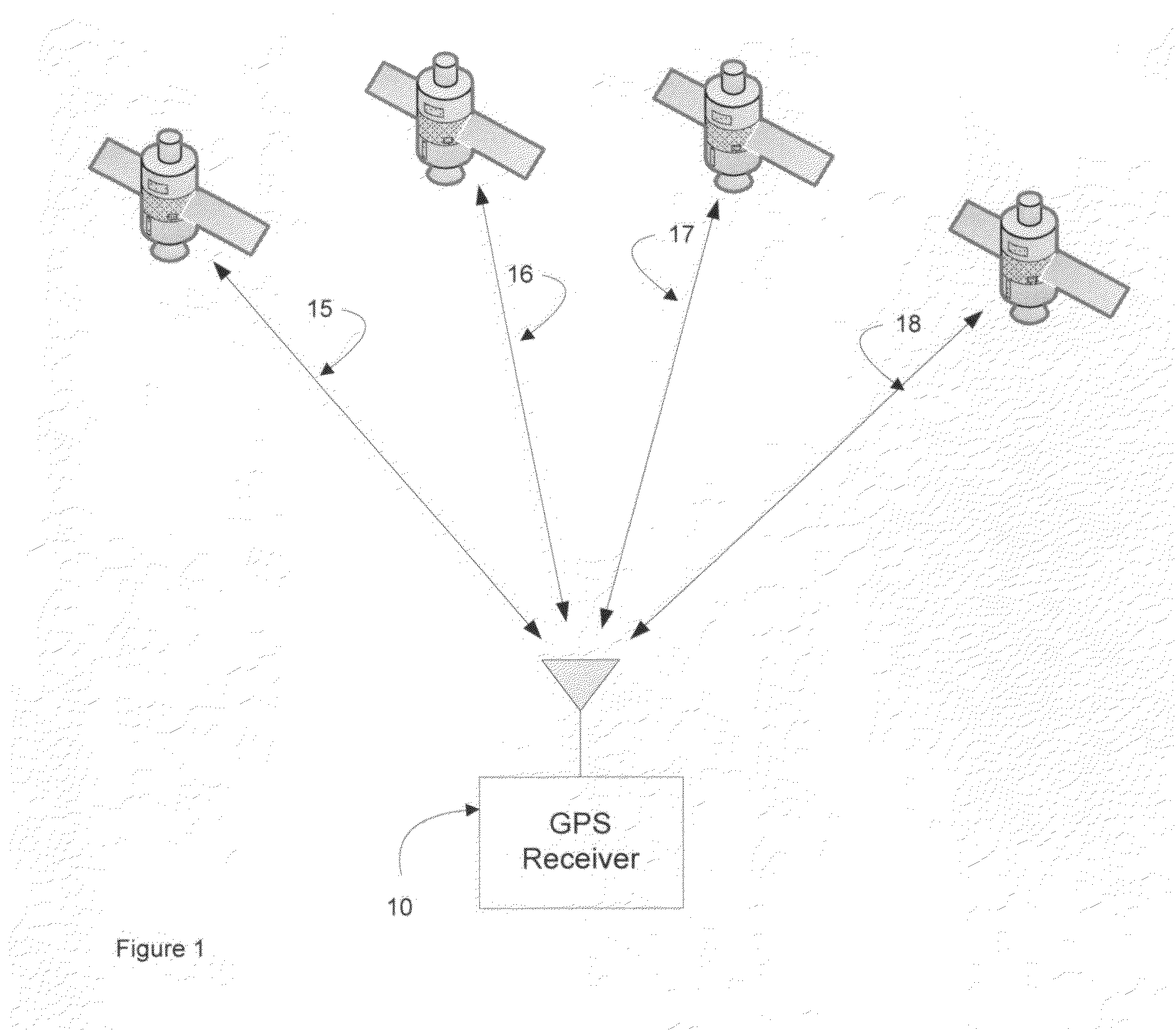
[0009]In order to overcome the TTFF disadvantages of GPS receiver 30, a prior art GPS receiver 50, with GPS assistance system 59 has been introduced (see FIG. 5). The role of GPS assistance system 59 is to track, the satellites “acquirable” in the vicinity of GPS assistance system 59. Accordingly, the GPS signal from GPS satellite constellation 56 is received by the R / F front end 51 of GPS receiver 50. R / F front end 51 down converts the 1.57 GHz R / F signal, resulting in an intermediate frequency (I / F) signal. The streaming I / F signal is examined by correlator 52, which is used to acquire satellites. To expedite the acquisition process, frequency information derived by GPS assistance system 59 in the course of tracking acquirable satellites, is transmitted to GPS receiver 50. This information is used to set the local frequency used by the search algorithm of correlator 52, enabling the search algorithm to operate more efficiently and more effectively. As a result the TTFF is significantly reduced, and receive sensitivity is improved slightly at the margin. Once pseudo range information has been determined for a minimum of four GPS satellites, the location coordinates are determined by coordinate generator 55. In addition to frequency information, ephemeris parameters may be transmitted to GPS receiver 50 from GPS assistance system 59. This information, however, does not affect the receive sensitivity of GPS receiver 50.
[0013]In general, the object of the present invention is to provide methods and apparatus to increase the receive sensitivity of GPS receivers in order to provide for the reliable determination of location coordinates in indoor and urban canyon operation. To this end, novel signal processing techniques reducing the minimum signal strength required to acquire a satellite in indoor and urban canyon environments are disclosed. The use of multiple GPS sensors provides the conceptual framework for such techniques. In this context, GPS sensors are characterized as one of two types: target GPS sensors, whose location is to be determined; and reference GPS sensors, used in the derivation of a reference used to increase the receive sensitivity of target GPS sensors.
[0014]The reduction in the minimum signal strength required to acquire a satellite (characterized as an increase in receive sensitivity) results from two types of innovation. To enable these innovations, the prior art GPS receiver has been rearchitected, as described in FIG. 6. In addition to the repartitioning of the basic functions—opening the signal processing platform to sophisticated techniques—the concept of the perfect reference is introduced, which in turn enables the second innovation—a buried-signal equalization technique effective in reducing if not eliminating the effects of multi-path.
[0015]Specifically, the invention postulates the embedding of simple GPS sensors at the points of measurement, receiving and recording signals transmitted by navigational satellites, and forwarding the recordings (datagrams) to central datagram processing facilities. Significant in this partitioning is the fact that this enables a practical solution to the challenge of processing large datagrams, which in turn enables signal processing gains that translate into a reduction in the minimum signal strength required to acquire a satellite.
[0016]Exploiting the opportunity enabled by this repartitoning, and mindful of the utility of multiple sensors, a signal processing technique called perfect reference generation has been developed. Perfect reference generation is a novel technique for optimizing the extraction of pseudo ranges from datagrams recorded at target GPS sensors, whether by correlation or by equalization techniques. The perfect reference, extracted from a datagram recorded at a reference GPS sensor designated for the express purpose of perfect reference generation, is a reconstruction of the transmitted signal based on the analysis of large datagrams. In the process of perfect reference generation, satellite timing is derived, thus eliminating the requirement for a fourth satellite to fix location coordinates, and further reducing the minimum signal strength required to acquire a satellite.
[0017]Finally, classic equalization concepts have been adapted to the case in which the signal is buried in noise; with the leverage of the perfect reference, the recombination of multi-path signals is reduced to a tractable mathematical formulation. As a result, the minimum signal strength required to acquire a satellite is reduced even further.

Problems solved by technology

Because current GPS processing techniques are unable to provide the receive sensitivity required for reliable indoor operation, these applications have developed slowly.
Since this is impractical with current GPS navigational platforms, the computation of location coordinates is generally accomplished using four pseudo ranges.
To date, no such technology has been developed for applications in which the signal is buried in noise, such as satellite positioning.
The impact of this can be confounding to the prior art GPS receivers described in the paragraphs which follow.
The granularity of these steps is limited by the amount of over sampling that is performed on the incoming I / F signal.
There are a number of drawbacks to this approach, including a long time to first fix (TTFF) and reduced receive sensitivity in certain situations (e.g., those involving severe path loss or multi-path).
The ability of GPS receivers 30 and 50 to reliably obtain a GPS fix in indoor and urban canyon environments has been shown to be severely limited.
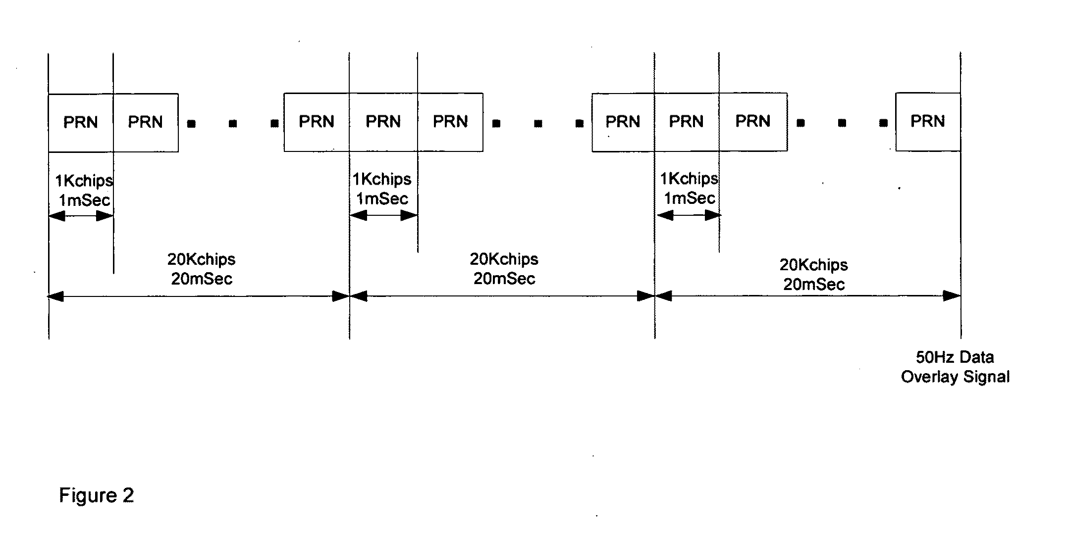
Furthermore, complicating the satellite acquisition process is the fact that the I / F signal carries a 50 Hz data overlay signal with bit boundaries occurring after 20 consecutive PRN code intervals.
To surmount the barrier imposed by the 50 Hz data overlay and enable the correlator to examine substantially larger amounts of data is impractical within the envelope of a battery-powered handheld device.
While it represents an interesting repartitioning of the basic GPS receiver, the rearchitecting essential to improve the sensitivity of the basic GPS receiver has not been addressed.

Method used


Image

  • Signal processing techniques for improving the sensitivity of GPS receivers
  • Signal processing techniques for improving the sensitivity of GPS receivers
  • Signal processing techniques for improving the sensitivity of GPS receivers

Examples


Embodiment Construction

[0040]In general, the object of the present invention is to provide methods and apparatus to increase the receive sensitivity of GPS receivers in order to provide for the reliable determination of location coordinates in indoor and urban canyon operation. To this end, novel signal processing techniques reducing the minimum signal strength required to acquire a satellite in indoor and urban canyon environments are disclosed. The use of multiple GPS sensors provides the conceptual framework for such techniques. In this context, GPS sensors are characterized as one of two types: target GPS sensors, whose location is to be determined; and reference GPS sensors, used in the derivation of a reference used to increase the receive sensitivity of target GPS sensors.

[0041]The reduction in the minimum signal strength required to acquire a satellite (characterized as an increase in receive sensitivity) results from innovations in signal processing, enabled by the rearchitecting of prior art GPS...


PUM


Abstract

A system for measuring the pseudo range from a first GPS sensor to a designated navigational satellite, for use in a satellite positioning system (SPS) is comprised of first and second GPS sensors for receiving and recording first and second portions of the signal transmitted by the designated navigational satellite, the recordings referred to as the first and second datagrams; and means for transmitting the first and second datagrams to a datagram processing facility wherein the pseudo range from the first GPS sensor to the designated navigational satellite is extracted. The datagram processing facility for extracting the pseudo range is further comprised of a pseudo range engine for extracting a pseudo range from a datagram originating with said first GPS sensor, the location of which is to be determined, the extraction accomplished with the aid of a perfect reference; and a perfect reference engine for generating a perfect reference from a datagram originating with a second GPS sensor designated for the express purpose of perfect reference generation. The perfect reference reduces the minimum number of satellites required to fix a position from four to three, and further enables the pseudo range engine to recombine multi-path GPS signals.

Description

[0001]This invention relates to the determination of location coordinates of devices embodying GPS sensors.[0002]The NAVSTAR Global Positioning System (GPS) developed by the United States Department of Defense uses a constellation of between 24 and 32 Medium Earth Orbit satellites that transmit precise microwave signals, which allows devices embodying GPS sensors to determine their current location. The initial application was predominantly for military purposes, namely weapons targeting and troop deployment. The first widespread consumer based application was navigational assistance. These early applications shared similar operating conditions in that the GPS navigational devices (also called GPS receivers) were (1) used outdoors, and (2) co-located with the end-user. Because of the requirement for mobility, GPS receivers were typically battery-operated devices, with power consumption a critical design consideration.[0003]Today, a new wave of applications is emerging, requiring a w...

Claims


Application Information

Patent Timeline
IPC IPC(8): G01S1/00
CPCG01S19/25
Inventor FARROKHI, FARROKHWONG, DICKSONCOLLMEYER, ARTHUR J.
Owner ETHERWHERE CORP
Learn More