Method and apparatus for detecting objects from terrestrial based mobile mapping data

a mobile mapping and object detection technology, applied in the field of methods of detecting objects from terrestrial based mobile mapping data, can solve the problems of high-resolution laser scanners that are expensive, their use in common terrestrial measurements, and the analysis of image sequences is very time-consuming

Active Publication Date: 2010-01-28
TOMTOM GLOBAL CONTENT
View PDF0 Cites 66 Cited by
  • Summary
  • Abstract
  • Description
  • Claims
  • Application Information

AI Technical Summary

Benefits of technology

[0018]These features enable us to process very efficiently a source image. The source image are split up into multiple images having a very limited amount of pixels and which comprises depth information. By means of the depth information the candidate 3D images could be very efficiently scaled to real world size. Furthermore, the depth information enables us to calculate the real world sizes of the object represented by the candidate 3D image.
[0025]These features enable the engineer practicing the invention to very efficiently determine whether the candidate 3D image corresponds to the road sign or not.
[0029]adding depth information corresponding to the laser points corresponding to the surface to corresponding pixels of said intermediate candidate images to obtain the candidate 3D images. These features enable us to determine in a very early stage whether or not a cluster of laser samples corresponds to an object of interest which results in a further reduction of laser points be processed. This reduces subsequently the amount of intermediate images. This is especially achieved by taking into account the perpendicularity of a surface of the object of interest with respect to the driving direction of the vehicle. The driving direction of the vehicle serves as an approximation to the direction of the road. The computing effort is further reduced as a segment comprises a limited amount of pixels, the number of segments is reduced and no verification of the orientation of the object represented by the intermediate image has to be performed.
[0032]add candidate 3D image in dependence of size and shape to the group of objects. This feature enables the engineer practicing the invention to scale efficiently the candidate 3D image to obtain the real world size and shape of the object. Subsequently, the shape is measured and only candidate 3D images having a corresponding shape and size are added to a group of objects, which group could be stored in a database. In an embodiment only objects with a planar surface are detected.
[0044]combining the first and second group of objects. This embodiment enables us to improve the detection rate of the objects from the mobile mapping data.

Problems solved by technology

However, high resolution laser scanners are expensive which discourages their usage in common terrestrial measurements.
The analysis of the image sequences is very time consuming and costs a lot of processing power due to the vast amount of data to be processed.
Furthermore, high resolution laser scanner data is only suitable to detect objects by form, shape or position.

Method used


Image

  • Method and apparatus for detecting objects from terrestrial based mobile mapping data
  • Method and apparatus for detecting objects from terrestrial based mobile mapping data
  • Method and apparatus for detecting objects from terrestrial based mobile mapping data

Examples


first embodiment

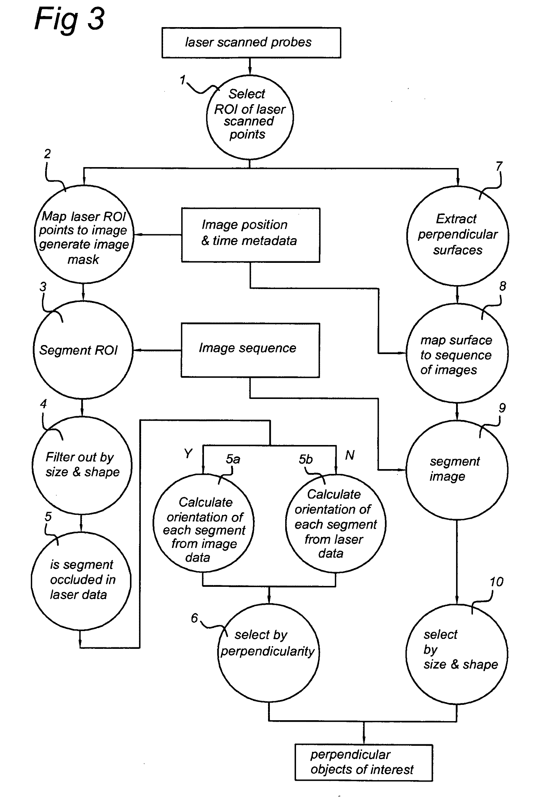
[0077]the invention comprises the following actions:[0078]1. select regions of interest for laser scanned points;[0079]2. map laser regions of interest to an image, generating a recognition mask;[0080]3. segment region of interest;[0081]4. filter segments by size and shape characteristics;[0082]5. determine whether segment is occluded;[0083]5a. calculate orientation of any occluded segments using the 6 degrees of freedom orientation system;[0084]5b. calculate orientation of non-occluded segments from laser data;[0085]6. select by means of filtering the perpendicular segments.

second embodiment

[0086]In the invention the method comprises the following actions:[0087]1. select regions of interest of laser scanned points;[0088]7. extract perpendicular surfaces from regions of interest;[0089]8. map perpendicular surfaces to images;[0090]9. perform color separation on image corresponding to surfaces;[0091]10. select, by means of filtering, surfaces by size and shape.

[0092]The respective actions of the first and second embodiment will be discussed in more detail below.

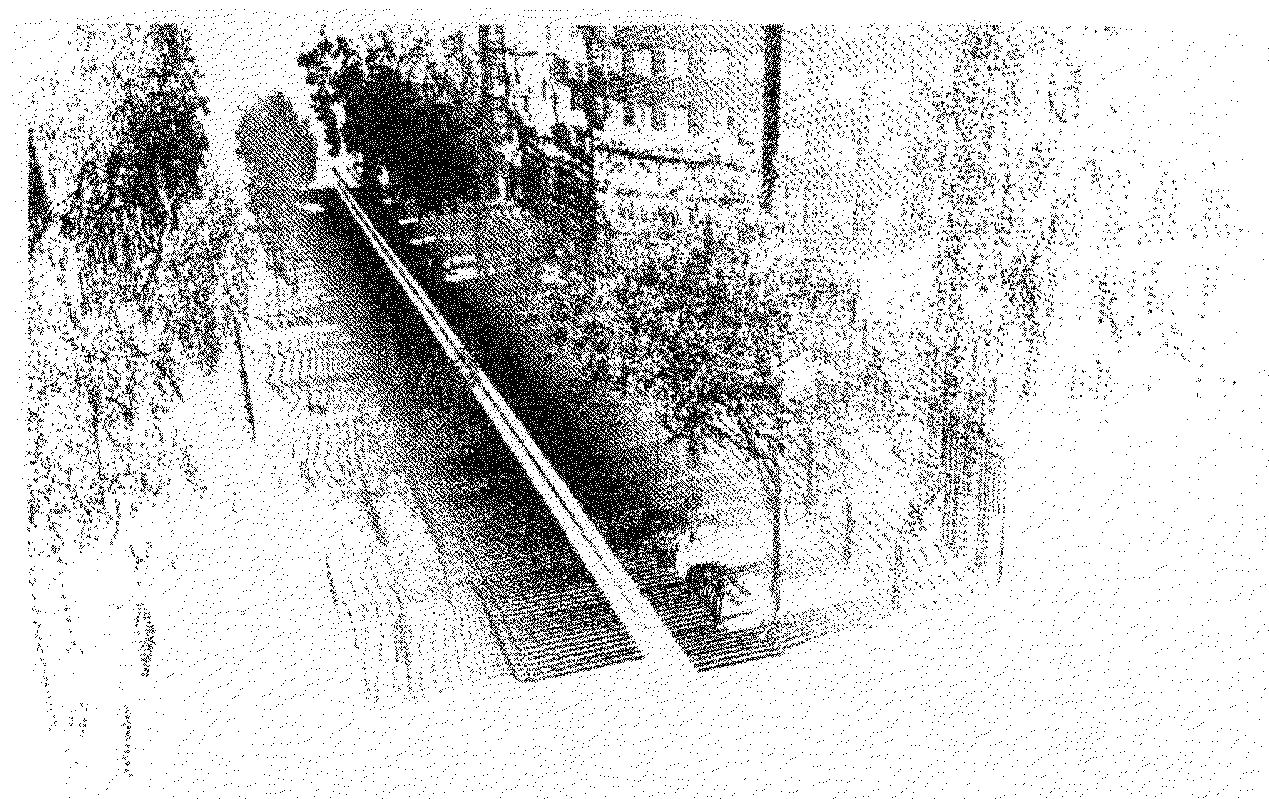
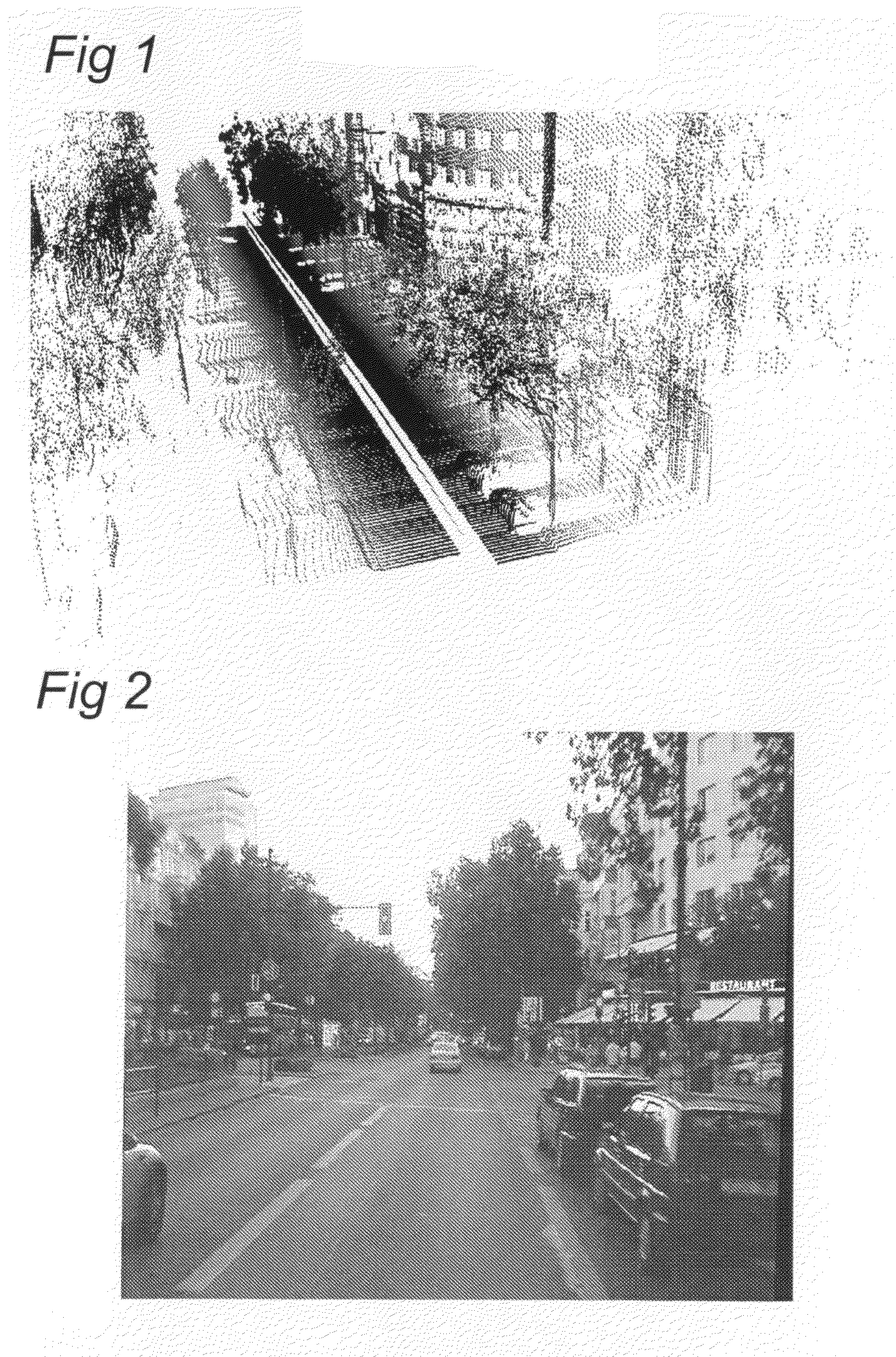
[0093]FIG. 3 is a flow diagram of a third embodiment of the method according to the invention. In the third embodiment the first and second embodiments have been combined. The left path corresponds to the first embodiment and the right path corresponds to the second embodiment. It has been found that the first embodiment and second embodiment perform uncorrelated processes. The method according to the first embodiment, which is based on image based recognition of planar objects enables us to detect 98% of the objec...


PUM


Abstract

A method of detecting objects from terrestrial based mobile mapping data is disclosed, wherein the terrestrial based mobile mapping data has been captured by way of a terrestrial based mobile mapping vehicle driving on a road having a driving direction, the mobile mapping data including laser scanner data, source images obtained by at least one camera and position and orientation data of the vehicle, wherein the laser scanner data includes laser points, each laser point having associated position and orientation data, and each source image comprises associated position and orientation data. In at least one embodiment, the method includes: retrieving a position and orientation of the vehicle; filtering the laser scanner data in dependence of the position and orientation of the vehicle to obtain laser points corresponding to regions of interest; retrieving a source image associated with the position and orientation of the vehicle; mapping the laser points corresponding to regions of interest to image coordinates of the source image to generate a recognition mask; combining the recognition mask and the source image to obtain candidate 3D images representative of possible objects within the regions of interest; and, detecting a group of objects from the candidate 3D images. By combining image recognition and laser scanner recognition the detection rate can be increased to a very high percentage, thereby substantially reducing human effort. Furthermore, the generating of regions of interest in the laser data, enables a significant reduction of the processing power and / or the processing time needed to detect the objects in the images.

Description

FIELD OF THE INVENTION [0001]The present invention relates to a method of detecting objects from terrestrial based mobile mapping data, wherein the terrestrial based mobile mapping data has been captured by means of a terrestrial based mobile mapping vehicle driving on a road having a driving direction, the mobile mapping data comprising laser scanner data, source images obtained by at least one camera and position and orientation data of the vehicle, wherein the laser scanner data comprises laser points, each laser point having associated position and orientation data, and each source image comprises associated position and orientation data. The invention further relates to an apparatus for capturing objects for use in a map database from terrestrial based mobile mapping data, a computer program and a processor readable medium carrying the computer program.PRIOR ART [0002]There is a need to collect a large number of “vertical” road information e.g. road signs, speed limits, directi...

Claims


Application Information

Patent Timeline
Patent Type & Authority Applications(United States)
IPC IPC(8): G06T15/00
CPCG06T7/0065G06T2207/10016G06T2207/10028G01C21/32G06T2207/30236G06T2207/30252G01C11/025G06T2207/30184G06T7/70G06T7/55G01C21/3811G01C21/3848G01C21/3837
Inventor TABOROWSKI, LUKASZ PIOTRGLISZCZYNSKI, RAFAL JANWYSOCKI, ARKADIUSZKMIECIK, MARCIN MICHAL
Owner TOMTOM GLOBAL CONTENT
Why Eureka
Try Eureka