[0004]It is an object of this invention to provide a computer
system and a computer-implemented method for generating a 3D geometric model and / or a definition of the 3D geometric model from a single digital image of a building facade, which system and method overcome at least some of the disadvantages of the prior art. In particular, it is an object of the present invention to provide a computer system and a computer-implemented method for generating efficiently a 3D geometric model and / or a definition of the 3D geometric model from an oblique
aerial image with
low resolution, or from a ground-based image with comparatively higher resolution. It is particularly a further object of the present invention to propose a computer-implemented method and a computer system for generating from a single digital image a 3D geometric model which has a significantly higher resolution and visual quality than the original
single image.
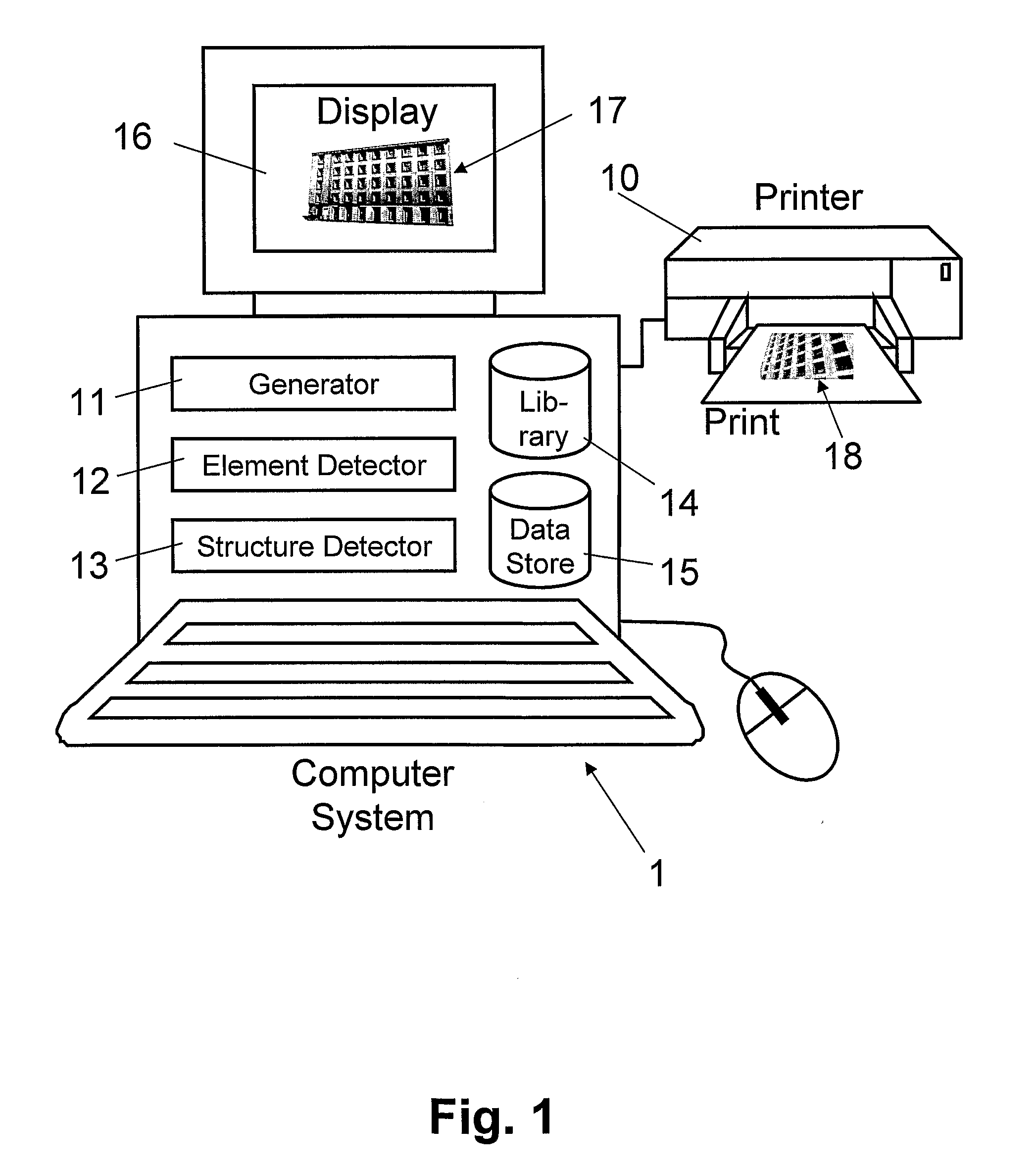
[0006]According to the present invention, the above-mentioned objects are particularly achieved in that for generating a 3D geometric model and / or a definition of the 3D geometric model from a single digital image of a building facade, the digital image is subdivided into image regions, determined in an architectural element
library 3D are architectural objects corresponding to the image regions, and the 3D geometric model or the definition of the 3D geometric model is generated based on the determined 3D architectural objects. Preferably, the definition of the 3D geometric model is a rules-based definition, particularly a rules-based parametric definition. Subdividing the digital image into image regions and assigning corresponding 3D architectural objects to the image regions makes it possible to generate automatically and efficiently a 3D geometric model with a higher resolution and visual quality than the aerial or ground-based input image. Thus, the proposed method makes it possible to enhance simple textured building
mass models constructed from aerial images and / or ground-based photographs, for urban reconstruction and / or
simulation applications, in which a user navigates virtually near ground level, for example a
virtual training application for
emergency response, applications in the entertainment industry, in
urban planning, for visual
impact analysis, for driving and / or military
simulation, which require interaction with a detailed model of high visual quality and realism, including
semantic information for meaningful
simulation.
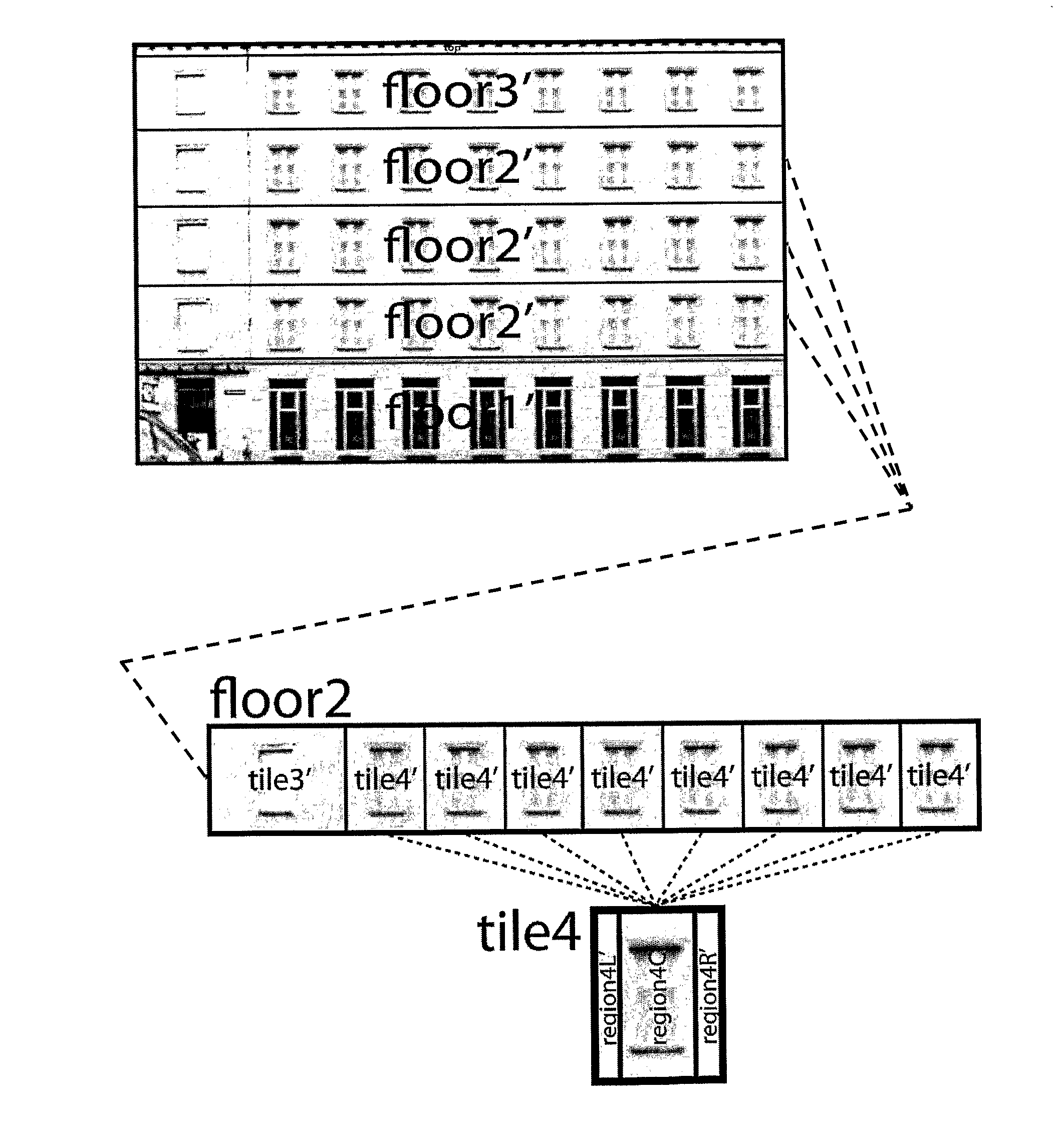
[0007]In a preferred embodiment, the digital image is subdivided into image regions by first detecting a facade structure from the digital image. The facade structure is detected by dividing the facade along horizontal lines into horizontal
layers representative of floors, and by dividing the horizontal layers along vertical lines into tiles. Preferably, the tiles are representative in each case of an architectural building element and its surrounding wall. Subsequently, the tiles are subdivided into a hierarchy of rectangular image regions. Finally, the 3D geometric model or the definition of the 3D geometric model is generated based on the facade structure, the hierarchy of image regions, and the 3D architectural objects associated with the image regions. This bottom-down detection of the facade structure and its association with 3D architectural objects from a library make possible an efficient and flexible (architectural) grammar based modeling which incorporates (architectural)
semantic information into the model. Furthermore, the detection of the facade structure and identification of the architectural elements make it possible to derive automatically exact dimensions, ratios and spacing of architectural elements.
[0008]Preferably, the detection of the facade structure includes determining similar horizontal layers by detecting vertical symmetry in a vertical direction, determining similar vertical columns by detecting horizontal symmetry in a horizontal direction, generating an irreducible facade structure with horizontal layers reduced to non-similar horizontal layers by stacking up the similar horizontal layers, and with vertical columns reduced to non-similar columns by stacking up the similar columns, and determining in the irreducible facade structure horizontal splitting lines which divide the facade into the floors, and vertical splitting lines which divide the facade into the tiles. Thus, the irreducible facade defines clusters (“stacks”) of similar tiles. Preferably, subdividing the tiles into the hierarchy of rectangular image regions includes aligning horizontal splits within horizontal rows of tiles, and aligning vertical splits within vertical columns of tiles, based on information about
horizontal and vertical repetition of similar tiles included in the irreducible facade structure, i.e. based on the clusters of similar tiles defined by the irreducible facade. Thus, the detection of translational symmetry not only improves the robustness of the
algorithm, but also ensures that similar elements are split at corresponding positions.
[0010]In a further embodiment, generating the 3D geometric model and / or the definition of the 3D geometric model is further based on
shader information associated with the 3D architectural objects. Thus, the 3D geometric model not only has an improved resolution and visual quality but also an increased perceivable visual realism, as material attributes such as
light reflection qualities are considered in generating the model.

