Micro unmanned aerial vehicle and method of control therefor

a micro-unmanned aerial vehicle and flight control technology, applied in the field of drones, can solve the problems of remote handlers, inability to mitigate anything, and insufficient delay to jeopardize or compromise remote drones, etc., to achieve effective collision avoidance systems, high degree of self-awareness, and high degree of stability

Active Publication Date: 2015-11-05
WESERVE DRONE LLC
View PDF0 Cites 71 Cited by
  • Summary
  • Abstract
  • Description
  • Claims
  • Application Information

AI Technical Summary

Benefits of technology

[0023]Accordingly, in a preferred embodiment, a micro unmanned aerial vehicle or drone is remotely controlled through an HMI, although this remote control is supplemented by and selectively suppressed by an on-board controller. The controller operates to control the generation of a sonar bubble that generally encapsulates the UAV. The sonar bubble, which may be ultrasonic in nature, is produced by a multiplicity of sonar lobes generated by specific sonar emitters associated with each axis of movement for the UAV. The emitters produce individual and beamformed sonar lobes that partially overlap to provide stereo or bioptic data in the form of individual echo responses detected by axis-specific sonar detectors. In this way, the on-board controller is able to interpret and then generate 3-D spatial imaging of the physical environment in which the UAV is currently moving or positioned. The controller is therefore able to plot relative and absolute movement of the UAV through the 3-D space by recording measurements from on-board gyroscopes, magnetometers and accelerometers. Data from the sonar bubble can therefore both proactively prevent collisions with objects by imposing a corrective instruction to rotors and other flight control system and can also assess and compensate for sensor drift.
[0024]Advantageously, the present invention provides a UAV system having a high degree of self-awareness that supports a highly stable flight-control system capable of providing an effective collision avoidance system. The UAV is therefore ideal for covert intelligence gathering and stealthy incursion, with the system controlled from a remote and thus generally safe location. In fact, the system of the present invention is sufficiently advanced so that it compensate for temporary loss of direct RF control, since the system can be set up to be self-regulating and is self-aware of its local environment. The preferred embodiment provides for a drone-based system that can plot the movement of the drone in 3-dimensional (3D) space and record all relative movements to fractions of a degree and millimetre precision.
[0025]Beneficially, the present invention provides environmental awareness for a UAV system that can be used autonomously to counter drift and furthermore provide enhanced (remote) control which benefits from a local, on-board decision-making system that functions to avoid collisions and / or UAV instability.
[0026]Furthermore, in being able to store a record (during ingress, for example, into a building and reflecting sonar-recovered data and monitored changes in gyroscopic, course heading and accelerometer measurements) of relative movement of the UAV, reversal of record of those recorded movements permits the UAV's controller to execute a rapid and controlled automatic egress of the UAV from the building.
[0027]Beneficially, inertial guidance is furthermore improved by use of the sonar bubble in the UAV of the preferred embodiment. Particularly, in a hover state, detected changes in echo path bouncing off an object and recovered at one or more sonar detectors implies a level of drift that can be identified, locked out and compensated by an internal controller of the UAV; this means that on-board sensors in the UAV can be locally calibrated by the local controller procedure. If the level of movement detected by a sensor is greater than self-determined levels of drift associated with that sensor, then the UAV's controller can resolve that the object is moveable and thus not part of the fixed environment. In building an accurate and current environmental map based on recorded sonar echos, the controller is therefore able to exclude obstacles that move with time.

Problems solved by technology

Indeed, fine manoeuvring control is required to permit secure and safe reconnoitre into buildings, with current line-of-sight systems entirely failing to mitigate anything that is not seen by the remote handler or which is only seen at a point that is too late to calculate a new flight path given current flight control settings, such as speed or altitude.
In fact, even a camera-based UAV system, transmission path delay or multi-path interference experienced in radio frequency (RF) operation may present sufficient delay to jeopardize or compromise the remote UAV drone.
This small size places considerable constraints on payload and motor size, with the motor technology relying on battery cells (such as lithium ion technology) for power.
Inertia navigation systems are, however, relatively expensive and are nevertheless susceptible to drift error.
With the passage of time, small errors in the measurement of acceleration and angular velocity are integrated into progressively larger errors in velocity, which are compounded into still greater errors in position.
In fact, drift can attributed to two processes: i) an offset from zero arising when there's no movement; and ii) a sensor resolution that is insufficient to detect small movements, these errors accumulate over time and result in an error in the calculated position.
Moreover, in the context of drift in sensors associated with maintaining level flight or controlling roll or yaw rates, continuous and unchecked drift can potentially critically compromise flight stability to the extent that the drone eventually crashes.
As such, the drift in inertial navigation is a real problem, although increasingly more sophisticated and larger multi-axis sensors with very high resolution can reduce (but not eliminate) the percentage drift error.
However, GPS isn't necessarily always available and, in any event, is likely to provide only an approximate location in the confines of a room in a building where there's no line-of-sight and / or where signal attenuating effects can compromise accurate position determination.
Clearly, large scale corrective systems do not fit well with the restriction imposed on weight, available power and the covert nature of micro or nano UAV drones.
In any event, laser-based systems are relatively heavy and therefore generally incompatible with the load constraints and energy resources associated with micro and nano UAV drones.

Method used


Image

  • Micro unmanned aerial vehicle and method of control therefor
  • Micro unmanned aerial vehicle and method of control therefor
  • Micro unmanned aerial vehicle and method of control therefor

Examples


Embodiment Construction

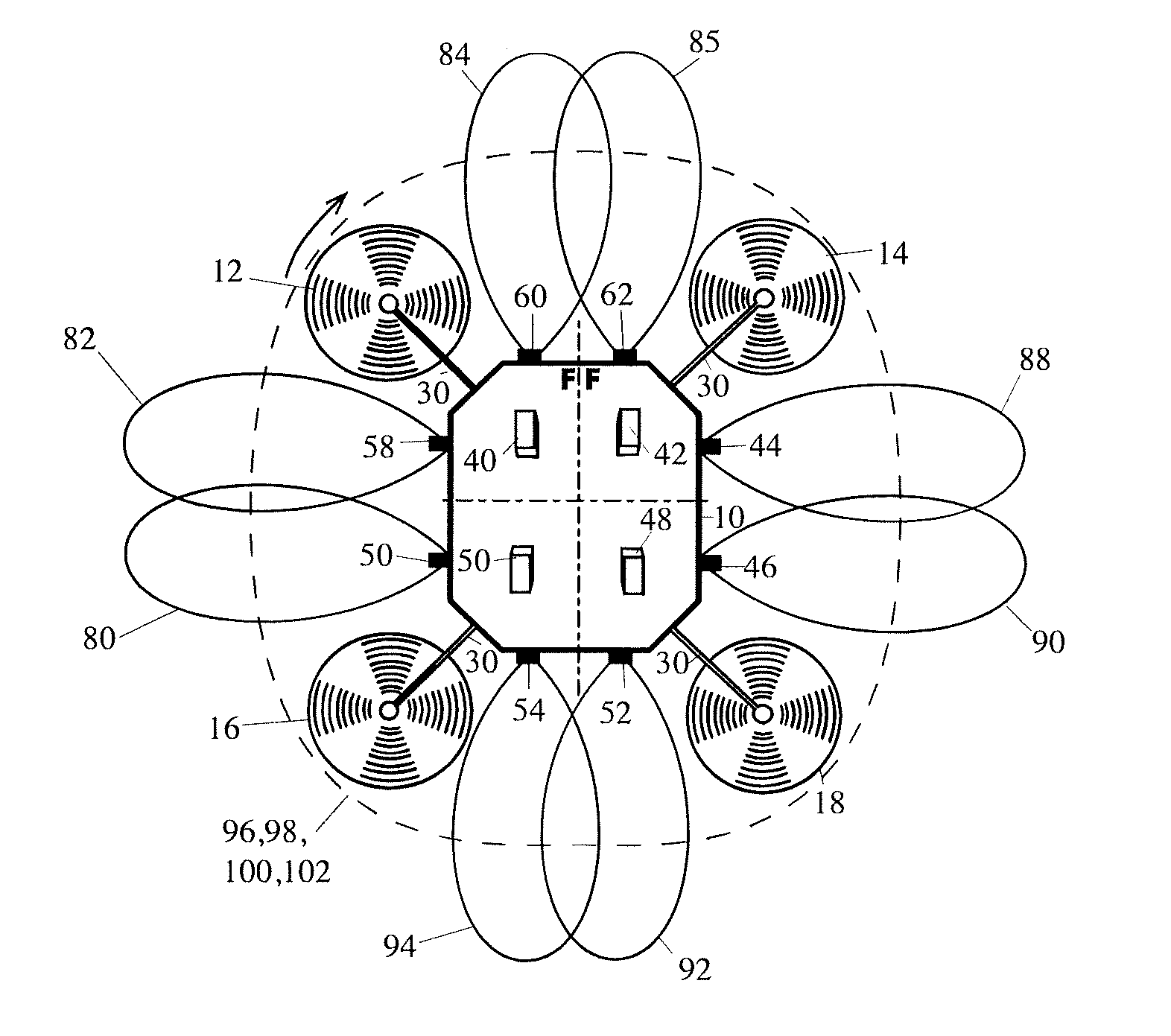
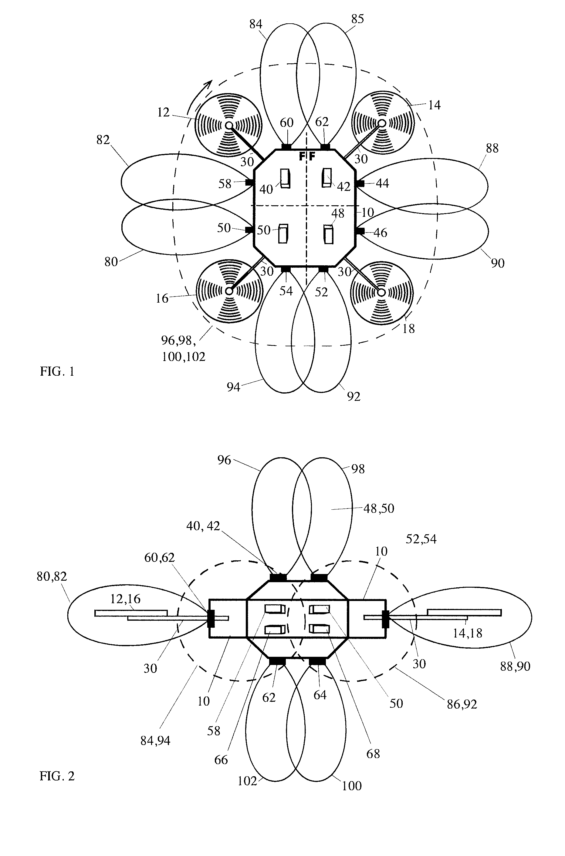
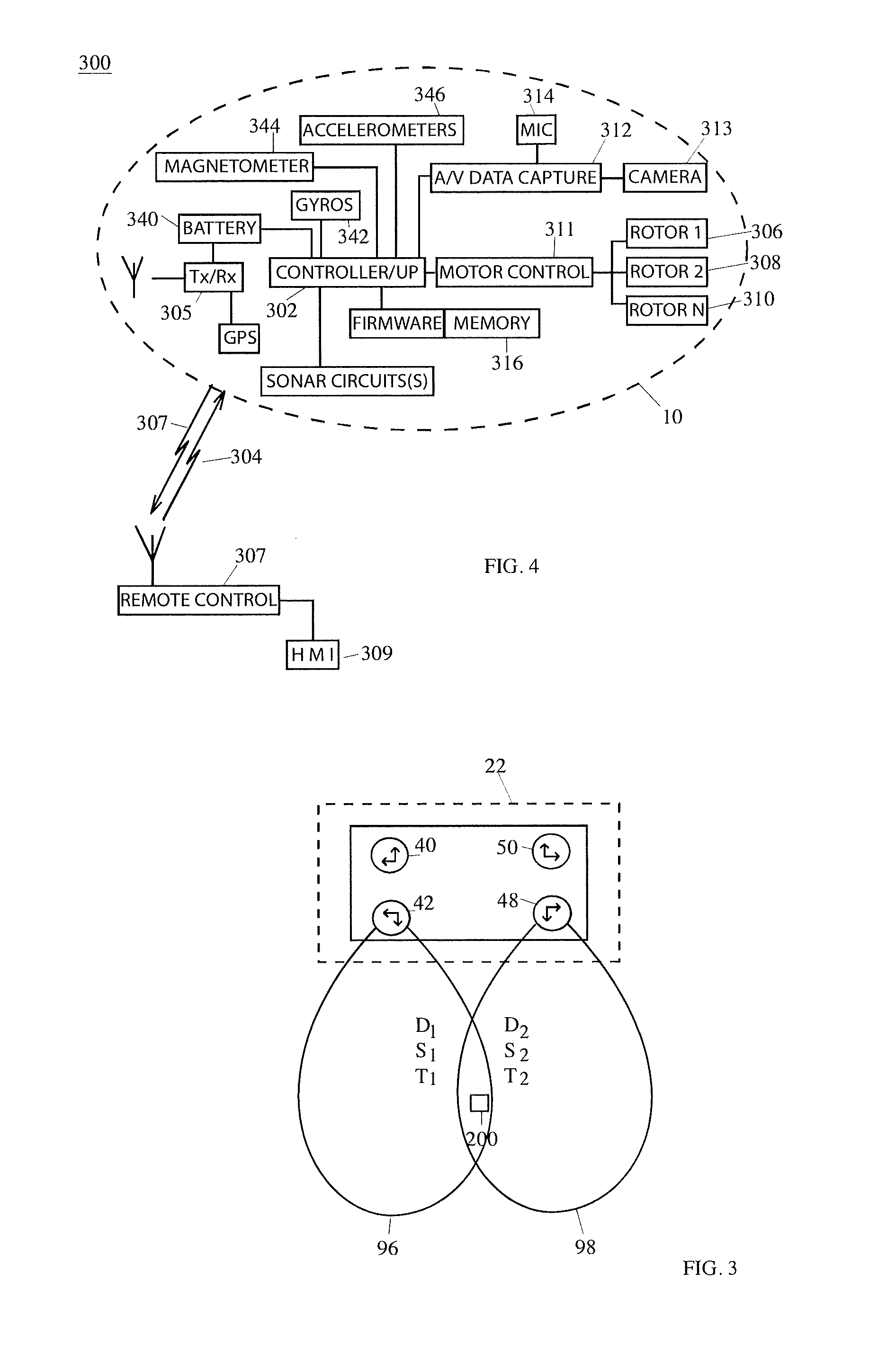
[0034]As a way of compensating for drift in motor control and general drift in the UAV arising from variation is air pressure and / or local currents or thermal effects, one might consider the use of collision bars or push rods (collectively “bumpers”) that strategically extend outwardly from the body of a UAV. In this way, the bumpers contact an obstacle and therefore mitigate the temporary loss of control. However, this approach is considered to be compromising and generally ineffectual given that range and usefulness of the UAV are dependent upon overall weight and unobtrusiveness. In this respect, the bumpers add to the overall weight (thus limiting the payload capabilities of the UAV) and increase the overall size of the UAV, thereby increasing the size of the UAV and potentially decreasing aerodynamics and the ability to control flight of the UAV. In fact, the use of bumpers, while logical, is fundamentally at odds with the functional requirement for a UAV since the bumpers serv...


PUM


Abstract

A micro unmanned aerial vehicle or drone (“UAV”) 10 is remotely controlled through an HMI, although this remote control is supplemented by and selectively suppressed by an on-board controller. The controller operates to control the generation of a sonar bubble that generally encapsulates the UAV. The sonar bubble, which may be ultrasonic in nature, is produced by a multiplicity of sonar lobes generated by specific sonar emitters associated with each axis of movement for the UAV. The emitters produce individual and beamformed sonar lobes that partially overlap to provide stereo or bioptic data in the form of individual echo responses detected by axis-specific sonar detectors. In this way, the on-board controller is able to interpret and then generate 3-D spatial imaging of the physical environment in which the UAV is currently moving or positioned. The controller is therefore able to plot relative and absolute movement of the UAV through the 3-D space by recording measurements from on-board gyroscopes, magnetometers and accelerometers. Data from the sonar bubble can therefore both proactively prevent collisions with objects by imposing a corrective instruction to rotors and other flight control system and can also assess and compensate for sensor drift.

Description

CROSS-REFERENCE TO RELATED APPLICATIONS[0001]This application claims priority to and is a continuation of U.S. patent application Ser. No. 14 / 310,307, filed Jun. 20, 2014, entitled “MICRO UNMANNED AERIAL VEHICLE AND METHOD OF CONTROL THEREFOR”, which application claims priority to, and the benefit of, PCT Application Serial No. PCT / GB2013 / 052745, filed on Oct. 22, 2013, entitled “MICRO UNMANNED AERIAL VEHICLE AND METHOD OF CONTROL THEREFOR”, which also claims priority to and the benefit of Great Britain Patent Application No. 1218963.5, entitled “MICRO UNMANNED AERIAL VEHICLE AND METHOD OF CONTROL THEREFOR”, filed on Oct. 22, 2012. All of the aforementioned applications are incorporated by reference herein in their entirety.BACKGROUND TO THE INVENTION[0002]The present invention relates, in general, to a unmanned aerial vehicle (UAV) and is particularly, but not exclusively, applicable to a flight control system for a micro or nano UAV that is tasked with reconnaissance and covert da...

Claims


Application Information

Patent Timeline
Patent Type & Authority Applications(United States)
IPC IPC(8): B64C39/02G05D1/10G01S15/89G05D1/00G01S15/93
CPCB64C39/024G05D1/0088B64C2201/141G01S15/89B64C39/028G05D1/101G05D1/102Y10S367/909B64U2201/10G05D1/106B64U10/00B64U2201/00B64C19/00B64C2230/00B64C2230/02G01S15/06G01S15/88G01S15/8913G01S15/8929G01S15/8993G01S15/93G05D1/0202
Inventor DAVIES, BARRY
Owner WESERVE DRONE LLC
Why Eureka
Try Eureka