Method of collaborative determination of positioning errors of a satellite-based navigation system

a satellite-based navigation system and positioning error technology, applied in satellite radio beaconing, measurement devices, instruments, etc., can solve the problems of limited and expensive solutions, affecting the calculation of pvt data by a receiver on the basis of satellite signals, and the widespread use of dual-frequency receivers by the general public is not yet widespread, so as to achieve faster acquisition of gnss signals and faster convergence of calculation

a satellite-based navigation system and positioning error technology, applied in satellite radio beaconing, measurement devices, instruments, etc., can solve the problems of limited and expensive solutions, affecting the calculation of pvt data by a receiver on the basis of satellite signals, and the widespread use of dual-frequency receivers by the general public is not yet widespread, so as to achieve faster acquisition of gnss signals and faster convergence of calculation

US20170307761A1Active Publication Date: 2017-10-26CENT NAT DETUD SPATIALES C N E S

Image

  • Method of collaborative determination of positioning errors of a satellite-based navigation system
  • Method of collaborative determination of positioning errors of a satellite-based navigation system
  • Method of collaborative determination of positioning errors of a satellite-based navigation system

Examples


Embodiment Construction

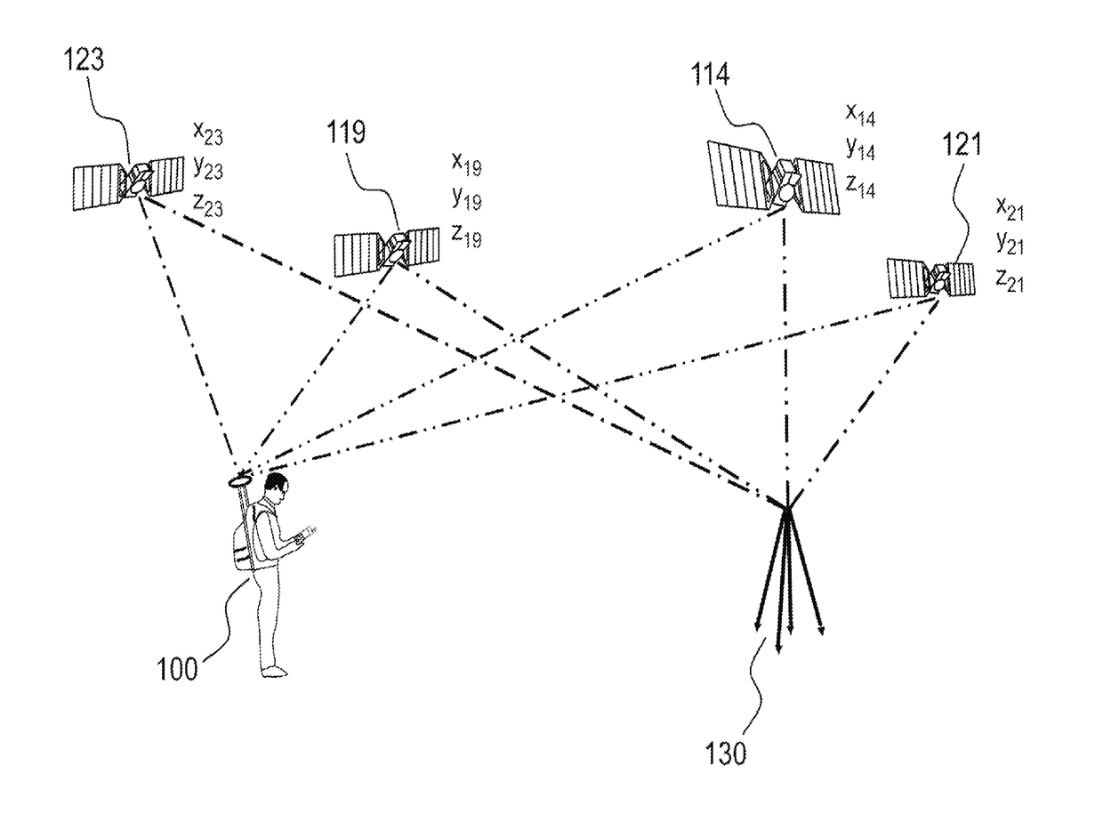
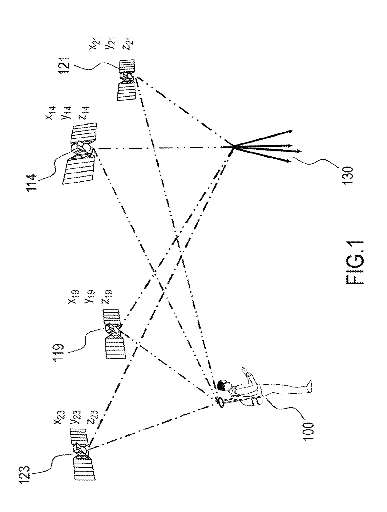
[0051]FIG. 1 represents a basic view of an RTK system according to the prior art.

[0052]In a positioning system of differential type, a user 100 receives positioning signals for at least one constellation of satellites, 114, 119, 121, 123. The positioning signals for said satellites are also received by a reference station 130. The user 100 can be mobile. The reference station 130 must be fixed, of precisely known position and situated in a radius of about 10 to 20 km from the user (see http: / / www.navidedia.netiindex.php / RTK Fundamentals).

[0053]An algorithm of RTK type can be implemented by using the code, the phase or a combination of the two, if appropriate with variable weightings. The precision is better when the phase is used, since its measurement is less noisy than that of the code, at the price of greater complexity, notably in order to remove the cycle ambiguity.

[0054]The basic equation of an algorithm of RTK type uses the following expression for calculating the phase cis o...


PUM


Abstract

The positioning signals broadcast by GNSS constellations are affected by significant errors, notably due to the crossing of the ionospheric layer or of the tropospheric layer. Several unwieldy means have been deployed to provide professional users with corrections of said errors. These means, however, all require the knowledge of at least one precise reference point at a given distance. According to the invention, positioning receivers that are not very precise, such as smartphones, present in a geographical zone, of unknown precise position, can contribute to the production of precise atmospheric error corrections if said receivers are sufficiently numerous.

Description

FIELD OF THE INVENTION[0001]The present invention applies to systems for aiding satellite-based navigation. More precisely, the aim of the invention is to produce information making it possible to determine the positioning errors resulting from the use of a satellite-based navigation signal.BACKGROUND[0002]The first constellation of satellites transmitting positioning signals was put in place for military applications by the American State (Global Positioning System or GPS) at the start of the 1980s. Since then, GPS signals have been used by professional civil applications (management of fleets of lorries, aids to aerial navigation, geodesic surveys, etc.), and henceforth for general-public applications (automobile navigation with onboard terminals and pedestrian navigation with terminals of smartphone type). Other constellations were put in place by the Russian State (GLONASS) and the Chinese State (BaIdou). A constellation of European satellites (Galileo) is undergoing deployment....

Claims


Application Information

Patent Timeline
26 Oct 2017
Publication
US20170307761A1
IPC
G01S19/07; G01S19/25
CPC
G01S19/25; G01S19/07; G01S19/40
Inventors
SCOT, GAEL; LAURICHESSE, DENIS