Method for estimating aboveground biomass of rice based on multi-spectral images of unmanned aerial vehicle

a multi-spectral image and aerial vehicle technology, applied in image enhancement, instruments, transportation and packaging, etc., can solve the problems of difficult application in large areas, low temporal-spatial resolution, and inability to accurately monitor rice biomass

Active Publication Date: 2020-05-07
NANJING AGRICULTURAL UNIVERSITY
View PDF0 Cites 53 Cited by
  • Summary
  • Abstract
  • Description
  • Claims
  • Application Information

AI Technical Summary

Benefits of technology

[0006]The present invention aims to provide a method for estimating the aboveground biomass of rice based on multi-spectral images of a UAV, which has low input data requirements, high estimation accuracy, and suitability for a whole growth period of rice.
[0022]Compared with the prior art, the present invention has the following technical effects:
[0023]1. The method for estimating the aboveground biomass of rice based on the multi-spectral images of a UAV consistent with the present invention has low input data requirements and high estimation accuracy.
[0025]3. The method for estimating the aboveground biomass of rice based on the multi-spectral images of a UAV consistent with the present invention can accurately monitor rice biomass during the whole growth period with only one model, and can provide a useful reference for crop growth monitoring.

Problems solved by technology

Although these sensors are easy to operate and have high monitoring accuracy, they are difficult to apply in large areas and are less efficient when applied to a large number of fields in agricultural parks.
Satellite imagery can monitor crop biomass on a large scale, but the image has low temporal-spatial resolution and a high spatial resolution image is expensive, resulting in low estimation accuracy.
However, these estimating models are only applicable to a single growth period, and a monitoring model for a whole growth period needs to be constructed.
However, the construction of the crop surface model requires image stitching and digital elevation models, which are time-consuming.
In addition, most of the existing studies have only used the spectral and structural information of the UAV images, and the inherent spatial information in the images has not been utilized.
Few studies have used ultra-high resolution UAV images to estimate rice biomass.
In addition, the traditional spectral index has a poorer monitoring effect under high biomass, especially at the growth period of rice after heading.

Method used


Image

  • Method for estimating aboveground biomass of rice based on multi-spectral images of unmanned aerial vehicle
  • Method for estimating aboveground biomass of rice based on multi-spectral images of unmanned aerial vehicle

Examples


embodiment 1

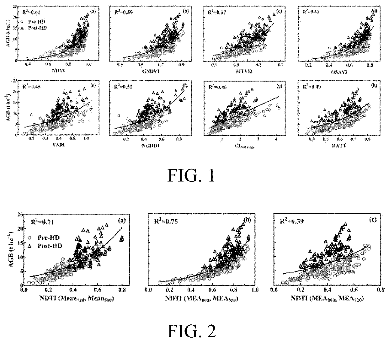
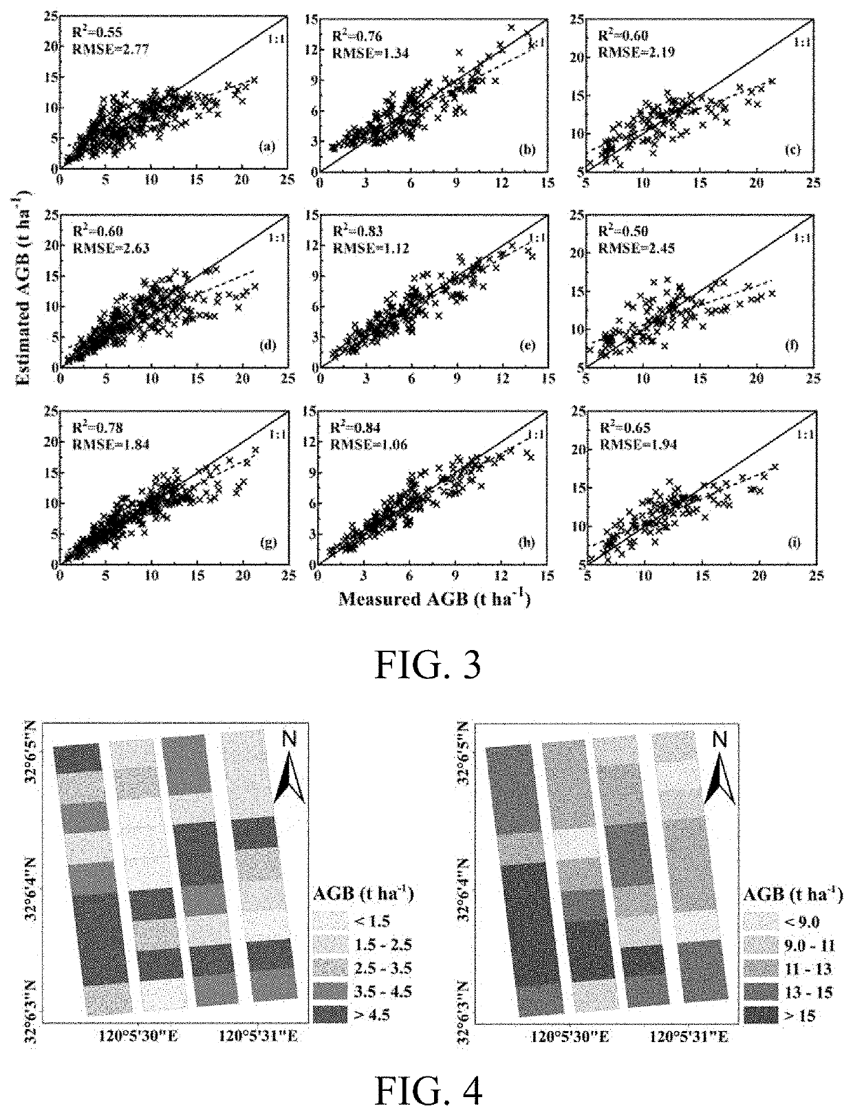
[0031]The method of present invention is performed based on rice field trials treated under different growth stages, different nitrogen application levels and different planting densities, and the specific expressions are shown in Tables 1 and 2:

TABLE 1Basic information of rice test fieldsSowingTransplantingNo.YearLocationVarietyTreatmenttimetimeExp. 12015Baipu Town,Japonica riceNitrogen levelMay 16June 15Rugao City,(Wuyunjing(kg ha−1):Jiangsu Province24); Indica0, 100, 200, 300.(120°45′ E,rice (YDensity: 0.30 m × 0.15 m32°16′ N)Liangyou 1)0.50 m × 0.15 mExp. 22016Baipu Town,Japonica riceNitrogen levelMay 18June 17Rugao City,(Wuyunjing(kg ha−1):Jiangsu Province24); Indica0, 150, 300.(120°45′ E,rice (YDensity: 0.30 m × 0.15 m32°16′ N)Liangyou 1)0.50 m × 0.15 m

TABLE 2Data collection of rice canopy images and agronomic parametersAcquisitiondate of UAVSamplingimagesdateGrowth periodData volumeAug. 5, 2015Jul. 31, 2015Jointing stage1 UAV multi-spectralimage, 36 pieces ofbiomass dataAug. ...


PUM

PropertyMeasurementUnit
reflectivityaaaaaaaaaa

Abstract

A method for estimating the aboveground biomass of rice based on multi-spectral images of an unmanned aerial vehicle (UAV), including: normatively collecting UAV multi-spectral image data of rice canopy and ground measured biomass data; after collection, preprocessing images, extracting reflectivity and texture feature parameters, calculating a vegetation index, and constructing a new texture index; and by stepwise multiple regression analysis, integrating the vegetation index and the texture index to estimate rice biomass, and establishing a multivariate linear model for estimating biomass. A new estimation model is verified for accuracy by a cross-validation method. The method has high estimation accuracy and less requirements on input data, and is suitable for the whole growth period of rice. Estimating rice biomass by integrating UAV spectrum and texture information is proposed for the first time, and can be widely used for monitoring crop growth by UAV remote sensing.

Description

BACKGROUNDTechnical Field[0001]The present invention belongs to the field of crop growth monitoring, in particular to a method for estimating the aboveground biomass of rice based on multi-spectral images of an unmanned aerial vehicle (UAV).Related Art[0002]Rice is one of the most popular grain corps in the world. More than half of the world's population depends on rice, so rice production plays an important role in global food safety and sustainable development. Accurate crop management is a prerequisite for a high yield of rice. Aboveground biomass is an important indicator for crop growth monitoring and has a significant impact on yield formation. At the same time, biomass and nitrogen content together determine a nitrogen dilution curve, from which critical nitrogen concentration can be obtained, and then a nitrogen nutrition index is calculated for nitrogen management. Therefore, accurate and non-destructive monitoring of crop population biomass plays an important role in the f...

Claims


Application Information

Patent Timeline
Patent Type & Authority Applications(United States)
IPC IPC(8): G01N21/84G01N21/25G06T5/00G06T7/40G06T7/62B64C39/02A01G22/22G06V10/143
CPCG01N2021/8466G06T5/002A01G22/22B64C39/02G06T2207/10036G06T5/006G06T7/40G06T7/62B64C2201/123G06T2207/30188G01N21/84G01N21/25G01N21/31G06T7/45G06T7/0002B64C39/024G06V20/194G06V20/188G06V10/143G06V20/17B64U2101/30
Inventor ZHU, YANZHENG, HENGBIAOCHENG, TAOYAO, XIATIAN, YONGCHAOCAO, WEIXING
Owner NANJING AGRICULTURAL UNIVERSITY
Why Eureka
Try Eureka