
Map data storage medium

a data storage medium and map technology, applied in navigation instruments, traffic control systems, instruments, etc., can solve problems such as unstandardized mesh allocation methods, and achieve the effect of efficient number assignmen

Inactive Publication Date: 2003-04-29
TOYOTA JIDOSHA KK +4
View PDF16 Cites 30 Cited by
  • Summary
  • Abstract
  • Description
  • Claims
  • Application Information

AI Technical Summary

Benefits of technology

This approach improves search efficiency by storing adjacent map data in numerical order, reducing search time, and enables systematic data access worldwide, facilitating rapid and efficient data retrieval for navigation and facility searches.

Problems solved by technology

In addition, when the world map is concerned, mesh allocation methods are not standardized, requiring separate systems be created for respective areas and data on the manner of allocating the meshes be provided.

Method used


Image

  • Map data storage medium
  • Map data storage medium
  • Map data storage medium

Examples


Embodiment Construction

A preferred embodiment of the present invention will next be described with reference to the drawings.

[Overall Configuration]

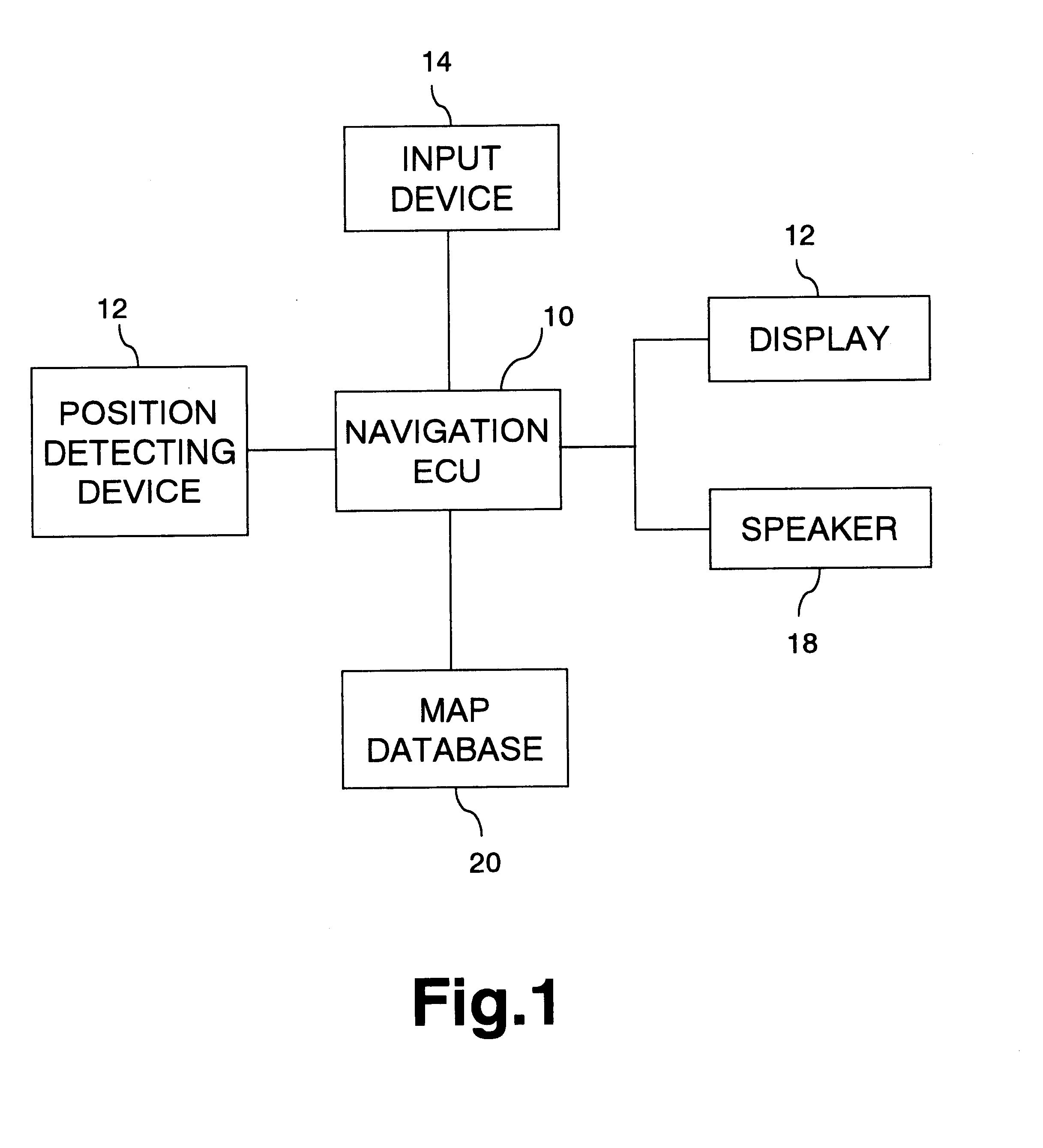
FIG. 1 is a block diagram illustrating an overall configuration of a navigation apparatus. A navigation ECU 10 performs various types of data processing for navigation, and is connected to a variety of devices as shown in the figure.

A position detecting device 12 including a GPS device or the like detects the current position of a vehicle. Various devices such as D-GPS devices, beacon receivers, and azimuth detecting devices may be employed. An input device 14 is used for entering commands such as operation commands, and formed by operation buttons, a touch panel, or the like. A display 16 presents a map image or the like used for navigation. When the input device 14 is a touch panel, the display 16 is preferably provided with a touch switch on a front surface thereof. A speaker 18 provides audio output of route guidance, operation guidance, and the like.

A map...


PUM


Abstract

Map data is divided into meshes of a prescribed size. Treating four meshes as one group, mesh numbers are assigned to the meshes following an N pattern. After numbers are assigned to the four meshes, these four meshes are collected as one, and numbers are assigned to respective meshes following an N pattern. The map data storage medium stores the map data according to mesh number. As a result, data portions for areas located in close proximity are positioned in close proximity in the map database (storage medium), to thereby improve access efficiency.

Description

1. Field of the InventionThe present invention relates to a map data storage medium (database) for storing map data divided into a plurality of meshes, and to a map information retrieving apparatus or a navigation apparatus utilizing the medium.2. Description of the Related ArtThe number of vehicles provided with on-vehicle navigation apparatuses for route guidance is increasing. Such a navigation apparatus is typically equipped with a map database carried on a storage medium such as a DVD, identifies a current position detected by a GPS (global positioning system) apparatus or the like as a position on the map, and displays the position. When a destination is set, an optimum route from the current position to the destination is searched for. More specifically, with data on road network contained in the map database, the shortest distance between the present position and the destination is searched for using linear programming to retrieve the optimum route. In addition to the distan...

Claims


Application Information

Patent Timeline
Patent Type & Authority Patents(United States)
IPC IPC(8): G01C21/34G09B29/00G01C21/00G01C21/32G06F17/30G08G1/0969
CPCG01C21/32G01C21/3874G01C21/3881
Inventor SUZUKI, HIDENOBUFURUIKE, YOSHIMASATOOYAMA, YASUHIROTAKEUCHI, HIROSHIOGAWA, ISAO
Owner TOYOTA JIDOSHA KK
Learn More