Enhanced GPS receiver utilizing wireless infrastructure

a wireless infrastructure and receiver technology, applied in the field of gps receivers, can solve the problems of excessively long time spent on obtaining reliable correlation, reducing the feasibility of achieving good correlation between stored replicas and detected signals, etc., and achieve the effect of improving the accuracy of pseudorange calculation

Inactive Publication Date: 2005-01-04
GOOGLE LLC +1
View PDF17 Cites 20 Cited by
  • Summary
  • Abstract
  • Description
  • Claims
  • Application Information

AI Technical Summary

Benefits of technology

An object of the present invention is to provide a method and an apparatus for calibrating a local oscillator of a mobile cellular unit in order to enhance the accuracy of pseudorange calculation to the GPS satellites.
A further object of the present invention is to provide a method of decreasing the time required for increased sensitivity in correlating weak GPS signal as performed in a mobile cellular unit.

Problems solved by technology

In urban environment and under dense canopy of trees, the satellite signals are likely to become weak, consequently decreasing the feasibility of achieving good correlation between stored replicas and a detected signal.
However, by performing the correlation for every estimate, the processing time is lengthened, resulting in excessively long time spent on obtaining a reliable correlation.

Method used


Image

  • Enhanced GPS receiver utilizing wireless infrastructure
  • Enhanced GPS receiver utilizing wireless infrastructure
  • Enhanced GPS receiver utilizing wireless infrastructure

Examples


Embodiment Construction

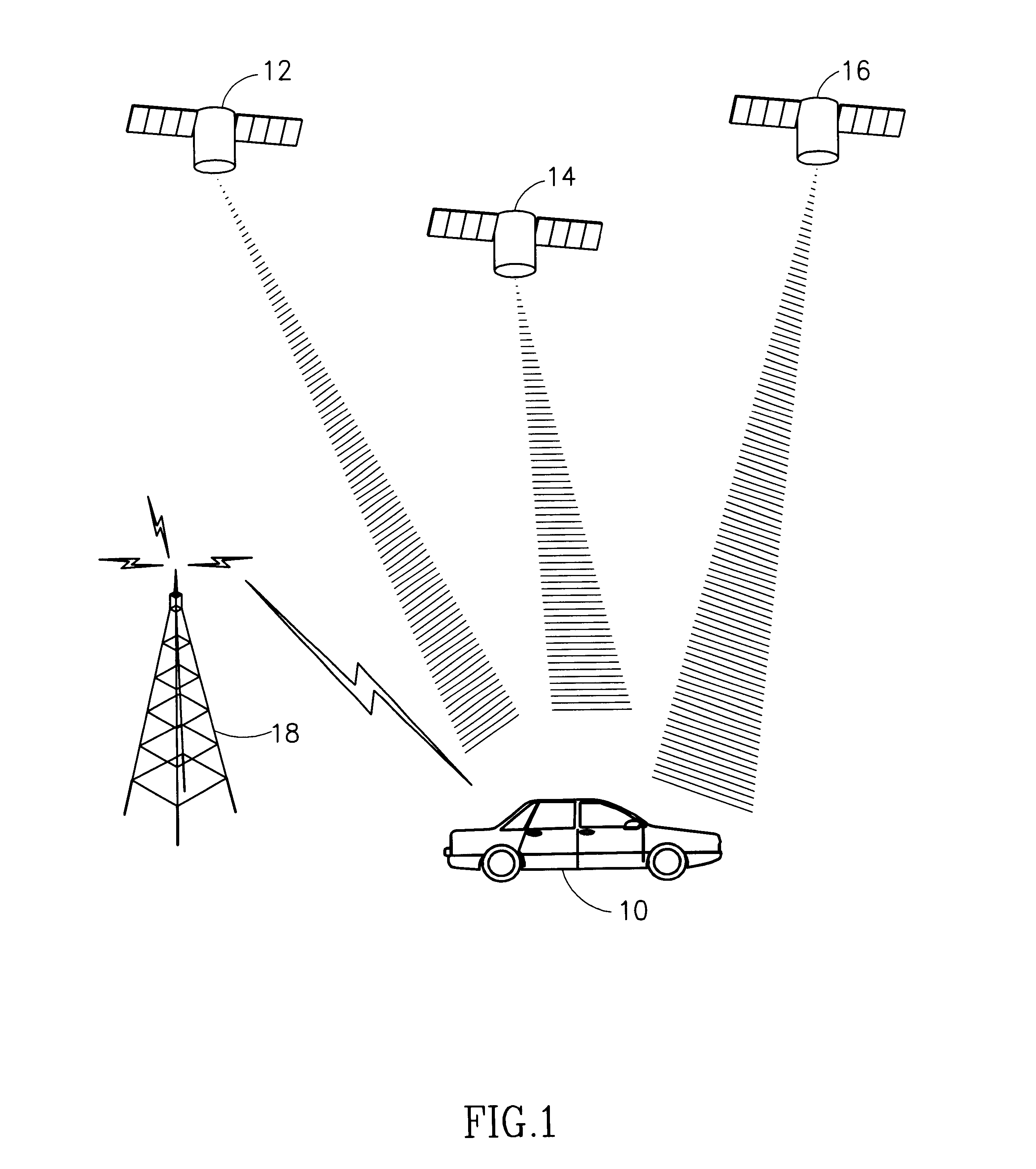
In order to perform location measurements, a standard commercial GPS receiver utilizes data of several satellites of the Navstar constellation concomitantly. According to the present invention, a typical data-source layout of a MU (mobile receiver unit) includes at least two types of data sources. FIG. 1 to which reference is now made, describes a MU receiving data from satellite sources 12, 14, and 16. According to the present invention, the locator integrated with a MU receives signals from a cellular network source 18 out of which synchronization data is extracted.

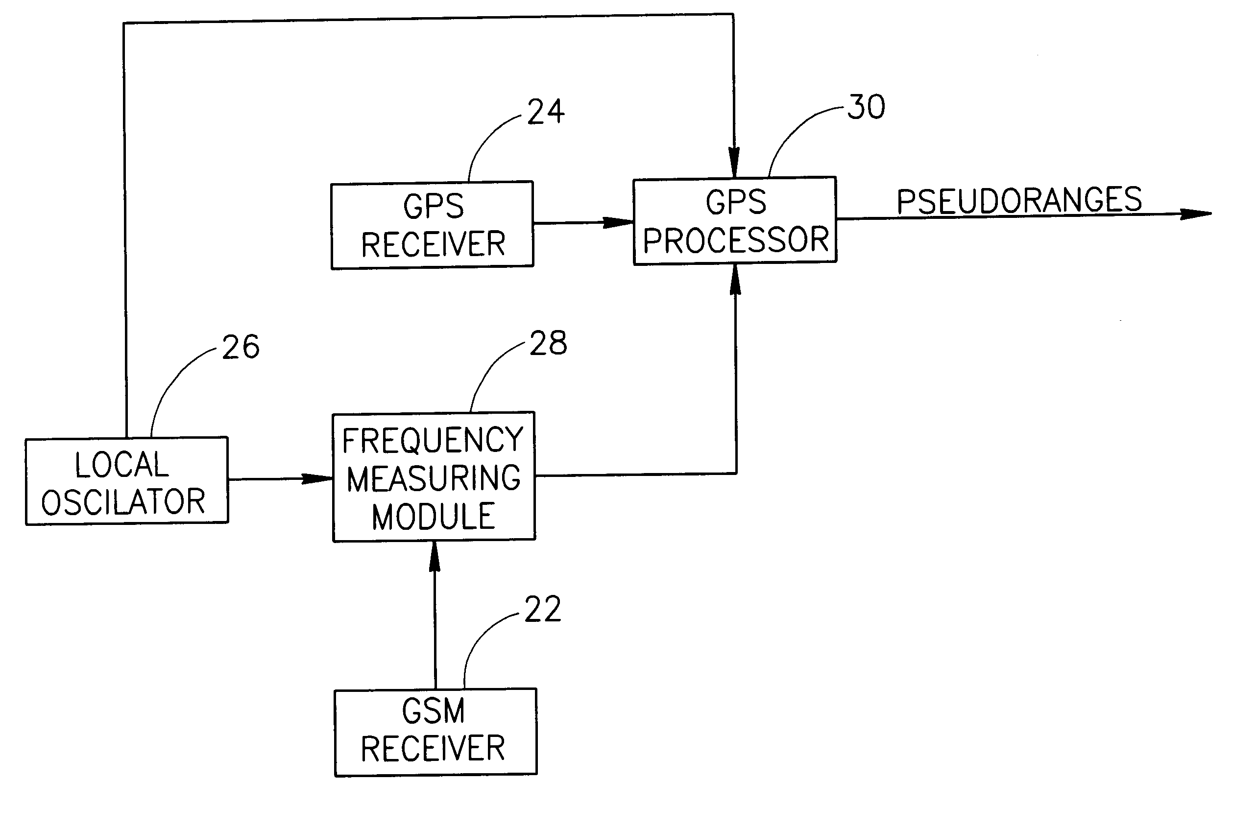
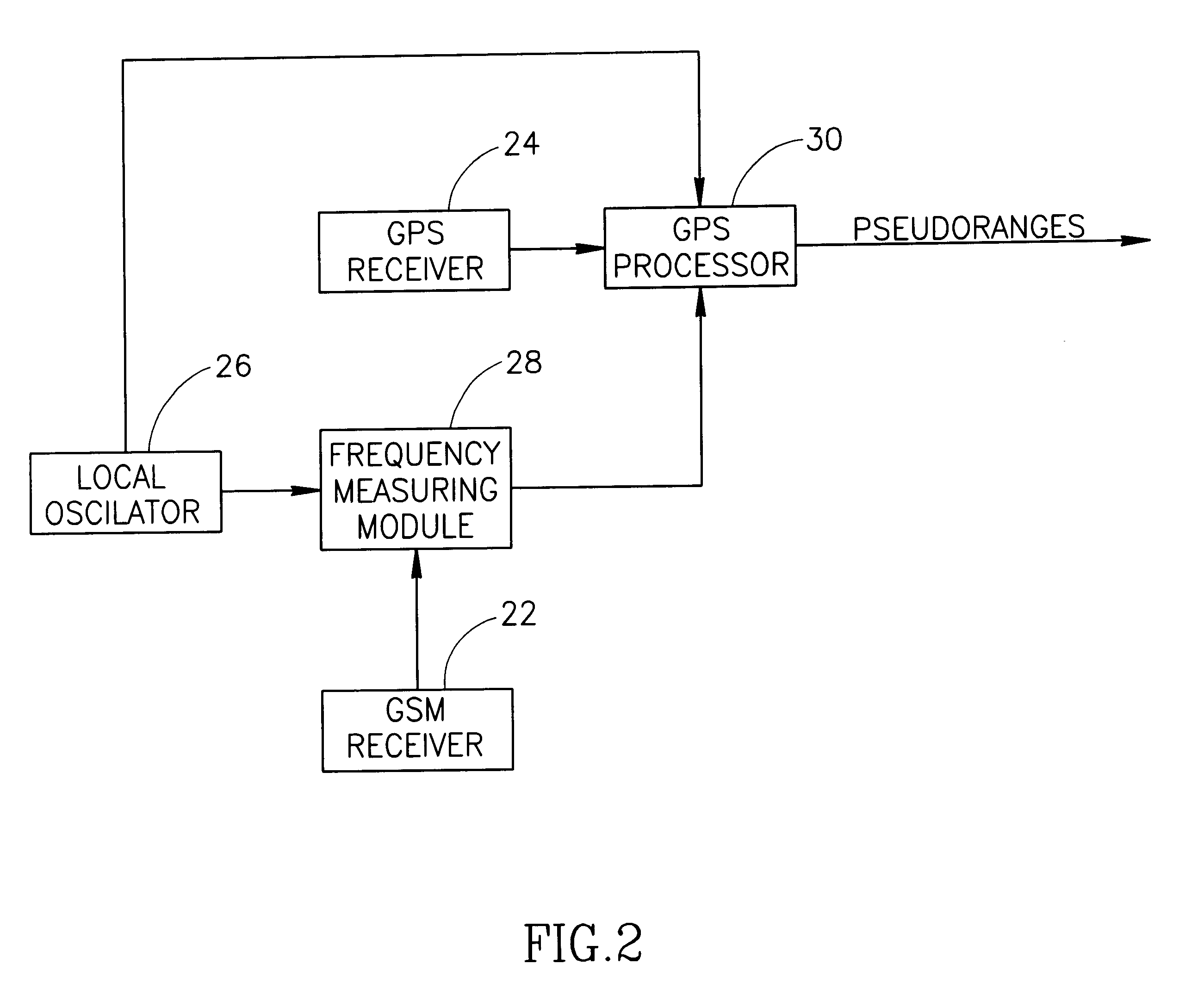
Correcting for Local Clock Frequency Shift

The local oscillator of the MU provides reference frequency for the time dependent processes associated with the location measurements. The local oscillator however exhibits drift characteristics which potentially impair the accuracy of the measurements.

According to the present invention, the local clock frequency shift is corrected for by referencing the MU's local oscillator t...


PUM


Abstract

A locator using Navstar constellation signals for determining geographical location of a mobile receiver. The locator is integrated with a mobile unit of a cellular network, which derives its reference frequency from a local oscillator (26). A frequency measuring module (28) counts the number of digital numbers derived from the local oscillator passing between two consecutive time-tagged indicators of the cellular network. The estimated frequency is calculated by dividing the number of digital numbers by the nominal time interval (T0) between the indicators.

Description

FIELD OF THE INVENTIONThe present invention relates to GPS receivers and more particularly to GPS devices incorporating links to a cellular communication network.BACKGROUND OF THE INVENTIONA standard GPS receiver determines its position relative to the satellite constellation by measuring propagation time of signals transmitted simultaneously from Navstar satellites. This constellation consists of 24 satellites each orbiting the earth in 12 hours time, such that any user has always a line of sight to 5-10 satellites. Each satellite transmits a continuous pseudorandom (PRN) noise sequence with a chip rate of 1023 KHz, and a repetition period of 1023 chips. Each satellite has its own particular PRN sequence, which has good correlation properties and is orthogonal to the PN sequences of the other satellites.Superimposed on the PRN sequence is a satellite data message. The data message includes positioning data (Almanac and Ephemeris), clock timing data and time of week (TOW) data. The ...

Claims


Application Information

Patent Timeline
Patent Type & Authority Patents(United States)
IPC IPC(8): G01S1/00G01S5/14H03J7/02G01S19/23G01S19/25
CPCH03J7/02G01S19/235
Inventor NIR, JOSEPHSHAYEVITS, BARUCHCOHEN, HANOCH
Owner GOOGLE LLC
Why Eureka
Try Eureka