System and method for advanced 3D visualization for mobile navigation units

a mobile navigation and advanced 3d visualization technology, applied in the field of visual navigation systems, can solve the problems of not providing route guidance applications for navigational assistance, using rendering software, and affecting the accuracy of navigational visualization, so as to improve the efficiency of navigational visualization, reduce unevenness and abrupt changes, and enhance the realism of the depiction

Inactive Publication Date: 2005-04-26
ROBERT BOSCH GMBH
View PDF27 Cites 84 Cited by
  • Summary
  • Abstract
  • Description
  • Claims
  • Application Information

AI Technical Summary

Benefits of technology

[0006]To enhance the realism of the depiction, the present invention provides a method for blending images of different resolutions pertinent to the viewing frustum in order to reduce unevenness and abrupt changes in the resulting depiction which would otherwise occur as the mobile unit moves closer toward, or further away from the depicted geographic area.
[0007]In addition, to increase the efficiency of the navigational visualization, the present invention also describes data structures for storage and run-time access of information regarding geographic landmark objects or POIs (Points of Interest). The data structures may permit on-demand loading of the objects based on the viewing frustum and / or a user request. The data structures may minimize the loading time, memory usage, processing requirements and display rendering resources by allowing the system to dynamically load, on-demand, only those objects that are visible and / or of interest to the user of the mobile unit.

Problems solved by technology

Using computer graphics software to accurately visually render the appearance of a local geographic environment in the view of a fixed observer (from a particular viewpoint chosen by the observer) is in itself a challenging task because of the difficulties involved in accurately simulating the various textures and graphical details of a scene in addition to the problems of reconstructing a scene according to the observer's viewpoint.
Using rendering software to depict the local geographic environment of a moving observer, such as a driver in a vehicle, in real-time is obviously far more challenging than rendering the environment of a fixed observer, because as the location of the observer changes, the geographic objects within his or her viewing horizon and the appearance of these objects change, requiring a continual updating mechanism by which new graphical objects (local “points of interest”), textures, features and views and other reference data can be readily downloaded to accurately render and provide information pertaining to the local navigated environment in real time.
Some visual navigation systems currently in use provide three-dimensional visualizations of real environments based on user input, but these systems either do not support mobile navigation, and thus do not provide route guidance applications for navigational assistance, or are limited in terms of the renderable viewpoint or the graphical features that can be displayed.

Method used


Image

  • System and method for advanced 3D visualization for mobile navigation units
  • System and method for advanced 3D visualization for mobile navigation units
  • System and method for advanced 3D visualization for mobile navigation units

Examples


Embodiment Construction

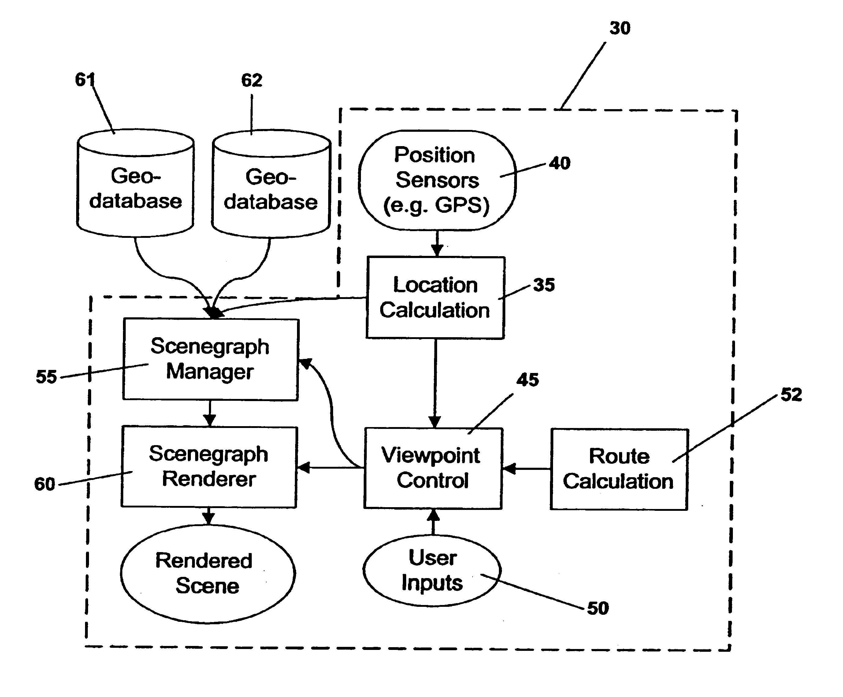
[0028]A system in accordance with the present invention generates a sequence of three-dimensional graphic visualizations, from an arbitrary viewpoint, of geographic areas for mobile navigation, orientation and reference. The graphic visualizations, or renderings, can contain representations of any type of data object for which local geographic information is available. Such data may include (without limitation) satellite, aerial, or ground view images, digital road maps, geometric models of buildings, textural descriptions of landscapes, and any kind of identification information that describes features or buildings in the depicted environment such as gas stations and hotels, or dynamic data, such as traffic information, weather conditions, and time of day (lighting).

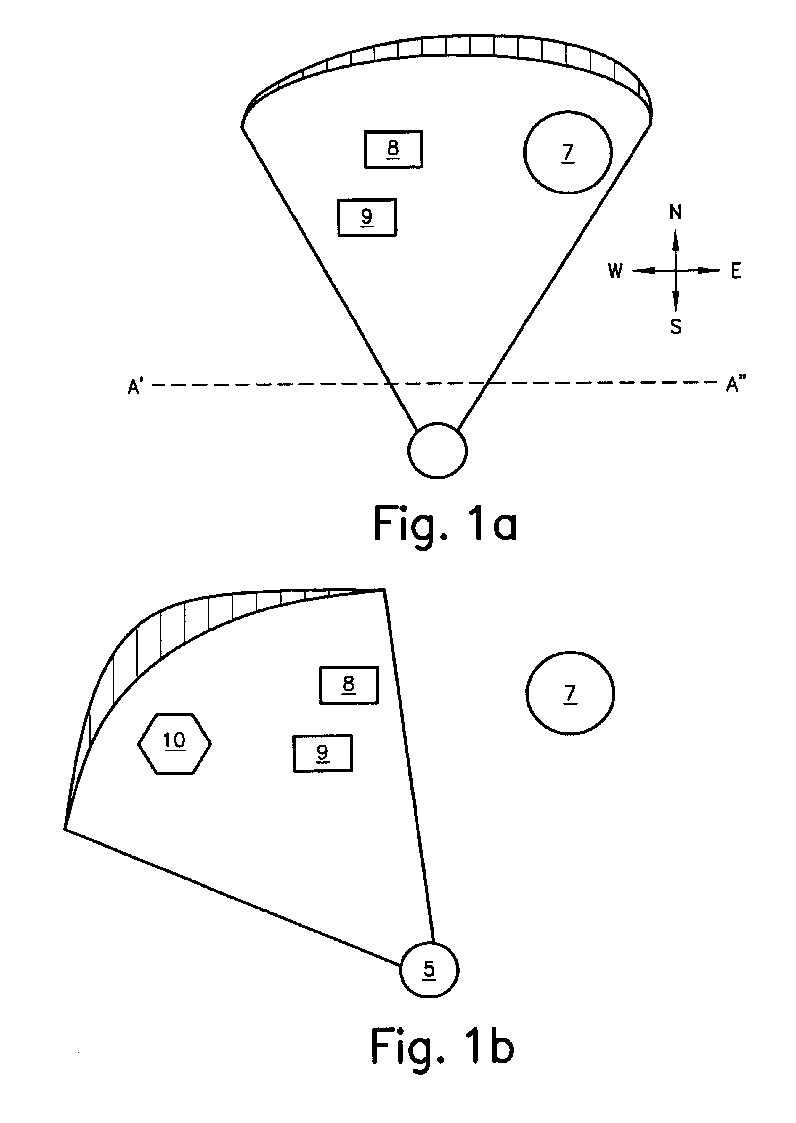
[0029]FIG. 1a and FIG. 1b illustrate how the informational parameters used to render the local environment change with the viewpoint (orientation) of the observer. In FIG. 1a, an observer 5 oriented “north” has a two-di...


PUM


Abstract

A system providing three-dimensional visual navigation for a mobile unit includes a location calculation unit for calculating an instantaneous position of the mobile unit, a viewpoint control unit for determining a viewing frustum from the instantaneous position, a scenegraph manager in communication with at least one geo-database to obtain geographic object data associated with the viewing frustum and generating a scenegraph organizing the geographic object data, and a scenegraph renderer which graphically renders the scenegraph in real time. To enhance depiction, a method for blending images of different resolutions in the scenegraph reduces abrupt changes as the mobile unit moves relative to the depicted geographic objects. Data structures for storage and run-time access of information regarding the geographic object data permit on-demand loading of the data based on the viewing frustum and allow the navigational system to dynamically load, on-demand, only those objects that are visible to the user.

Description

FIELD OF THE INVENTION[0001]The present invention relates to visual navigation systems, and relates more particularly to a system and method for visual display of geographically referenced data for mobile navigation, which includes a hierarchical method for on-demand loading of graphic landmark objects, and a method for multiresolution image synthesis to more efficiently and accurately depict local geographic environments.BACKGROUND INFORMATION[0002]Using computer graphics software to accurately visually render the appearance of a local geographic environment in the view of a fixed observer (from a particular viewpoint chosen by the observer) is in itself a challenging task because of the difficulties involved in accurately simulating the various textures and graphical details of a scene in addition to the problems of reconstructing a scene according to the observer's viewpoint. However, modern visual navigation systems under current development place a far greater demand on graphic...

Claims


Application Information

Patent Timeline
Patent Type & Authority Patents(United States)
IPC IPC(8): G01C21/34G09B29/10G01C21/36G06T17/05
CPCG01C21/3638G09B29/10G06F17/30905G06T17/05G06F17/30241G06T2210/61G06F16/29G06F16/9577
Inventor SCHMIDT, HAUKECHEN, TUOLINLEE, AARON
Owner ROBERT BOSCH GMBH
Why Eureka
Try Eureka