Adaptive GPS and INS integration system

a technology of integrated systems and gps, applied in wave based measurement systems, navigation instruments, instruments, etc., can solve the problems of affecting the responsiveness of a gps receiver, the processing load of a deep integration system is also high, and the carrier tracking loop is more sensitive to interference, so as to achieve the effect of convenient weighting of the kalman gain matrix

Inactive Publication Date: 2005-05-31
QINETIQ LTD
View PDF10 Cites 37 Cited by
  • Summary
  • Abstract
  • Description
  • Claims
  • Application Information

AI Technical Summary

Benefits of technology

[0025]The weighting of the Kalman gain matrix can conveniently be achieved by multiplying it by the time between successive (correlated) measurements divided by the time between successive un-correlated measurements.

Problems solved by technology

Processor loads in a deep integration system are also high and so this system has a number of drawbacks.
However, carrier tracking loops are more sensitive to interference and will lose lock at lower interference levels than code tracking loops.
The responsiveness of a GPS receiver is affected by noise (e.g. from interference with the GPS signal) and also by high dynamic vehicle manoeuvres.
If this fact is not addressed then the Kalman filter becomes unstable, resulting in degraded estimates.
Where the Kalman filter corrected INS data is used to aid GPS code tracking, a form of positive feedback can occur which eventually causes the GPS receiver to lose its tracking locks.
The navigation solution cannot be resurrected from the INS data alone, where the corrected INS data is used to aid GPS, either because there is no stand alone INS solution or because the INS solution, if available, is not accurate enough.
In cases where the receiver has adaptive tracking loop bandwidths tuning of the integration algorithm becomes more difficult.
This is obviously not an ideal solution since measurement data is being discarded which will inevitably result in a less than optimum navigation solution.

Method used


Image

  • Adaptive GPS and INS integration system
  • Adaptive GPS and INS integration system
  • Adaptive GPS and INS integration system

Examples


Embodiment Construction

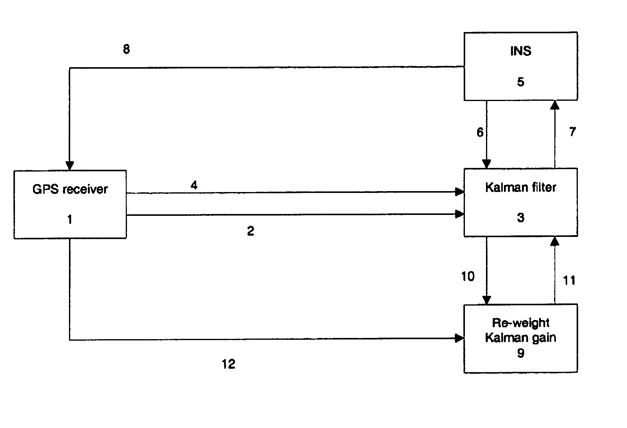
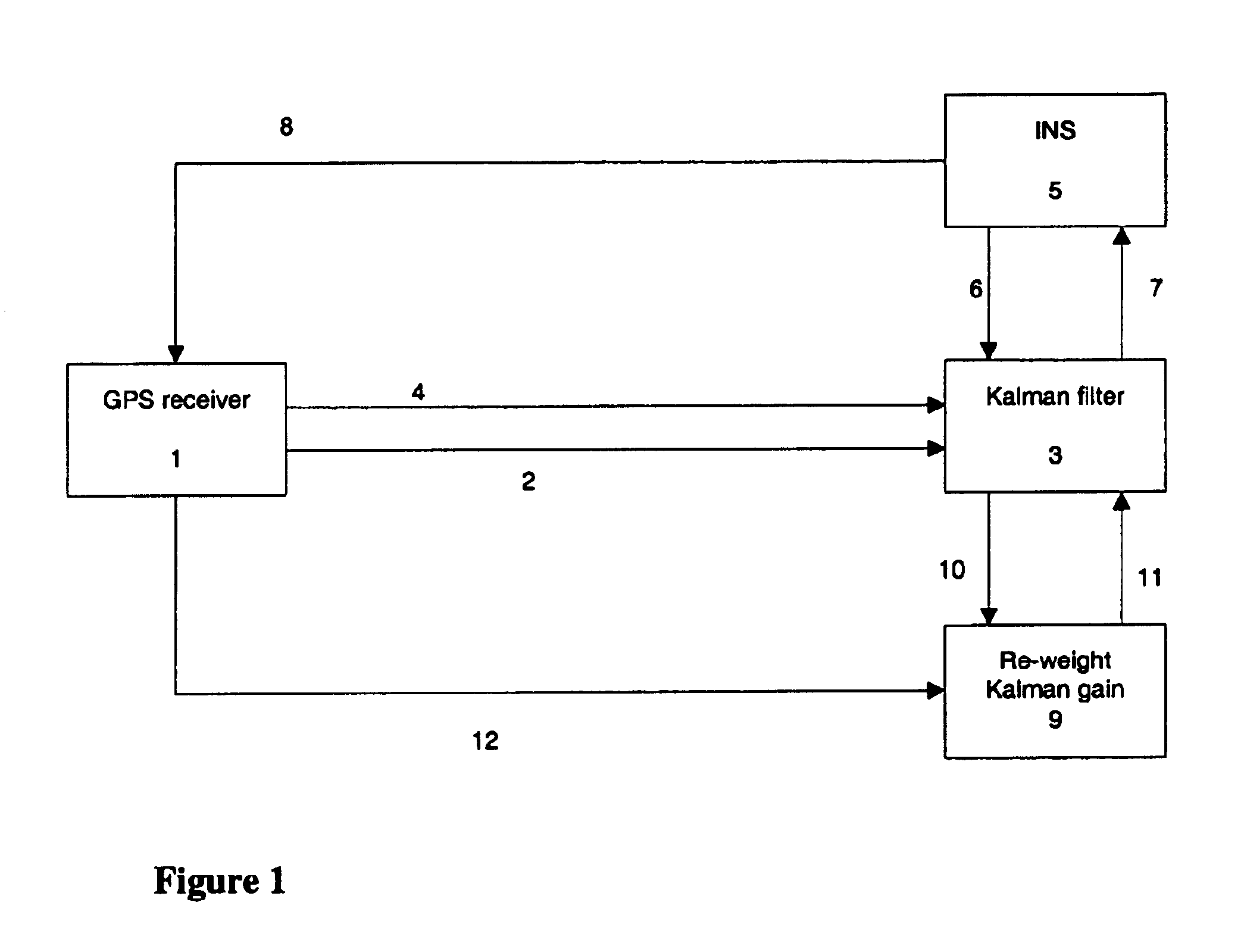
[0036]Turning to FIG. 1, a tightly coupled INS / GPS integrated navigation system is shown. A GPS receiver 1 is connected to a Kalman filter 3. An INS 5 is connected to the Kalman filter 3 and also the GPS receiver 1. A Kalman gain re-weighting function 9 is connected to both the Kalman filter 3 and the GPS receiver 1.

[0037]In use, the GPS receiver 1 outputs pseudo-range and pseudo-range rate measurements 2 to the Kalman filter 3. It is assumed that these pseudo-range and pseudo-range rate measurements have been combined from the individual L1 and L2 frequency measurements to correct for ionosphere propagation delays. The receiver 1 also sends GPS broadcast navigation data 4 to the Kalman filter 3, which enables the satellite positions, velocities and clock offsets to be calculated.

[0038]The INS 5 outputs position, velocity and attitude 6 measurements to the Kalman filter 3. The Kalman filter 3 (in a closed-loop architecture) sends corrections 7 back to the INS 5. These corrections co...


PUM


Abstract

This invention relates to the field of Inertial Navigation Systems (INS) and satellite navigation systems such as the Global Positioning System (GPS) and in particular relates to methods of integrating GPS and INS data in order to provide more accurate navigation solutions. The invention provides a method of improving the accuracy of a tightly coupled integrated INS and satellite radio navigation system in cases where the satellite navigation receiver has adaptive tracking loop bandwidths.

Description

[0001]This application is the U.S. national phase of international application PCT / GB01 / 02307, filed in English on 23 May 2001, which designated the U.S. PCT / GB01 / 02307 claims priority to GB Application No. 0013722.4 filed 7 Jun. 2000. The entire contents of these applications are incorporated herein by reference.BACKGROUND OF THE INVENTION[0002]1. Field of the Invention[0003]This invention relates to the field of Inertiai Navigation Systems (INS) and satellite positioning systems such as the Global Positioning System (GPS). In particular, this invention relates to methods of integrating INS and GPS data in order to provide more accurate navigation solutions.[0004]2. Discussion of Prior Art[0005]An INS comprises a set of accelerometers and gyroscopes, known as an inertial measurement unit (IMU), together with a navigation equations processor, which integrates the IMU outputs to give the position, velocity and attitude. GPS consists of a constellation of satellites which transmit nav...

Claims


Application Information

Patent Timeline
Patent Type & Authority Patents(United States)
IPC IPC(8): G01C21/10G01C21/16G01S1/00G01S5/14G01S19/26G01S19/47
CPCG01C21/165G01S19/26G01S19/47
Inventor GROVES, PAUL D.
Owner QINETIQ LTD
Why Eureka
Try Eureka