
GIS based real-time monitoring and reporting system

Inactive Publication Date: 2005-07-05
GROUNDSWELL TECH LLC
View PDF20 Cites 106 Cited by
  • Summary
  • Abstract
  • Description
  • Claims
  • Application Information

AI Technical Summary

Benefits of technology

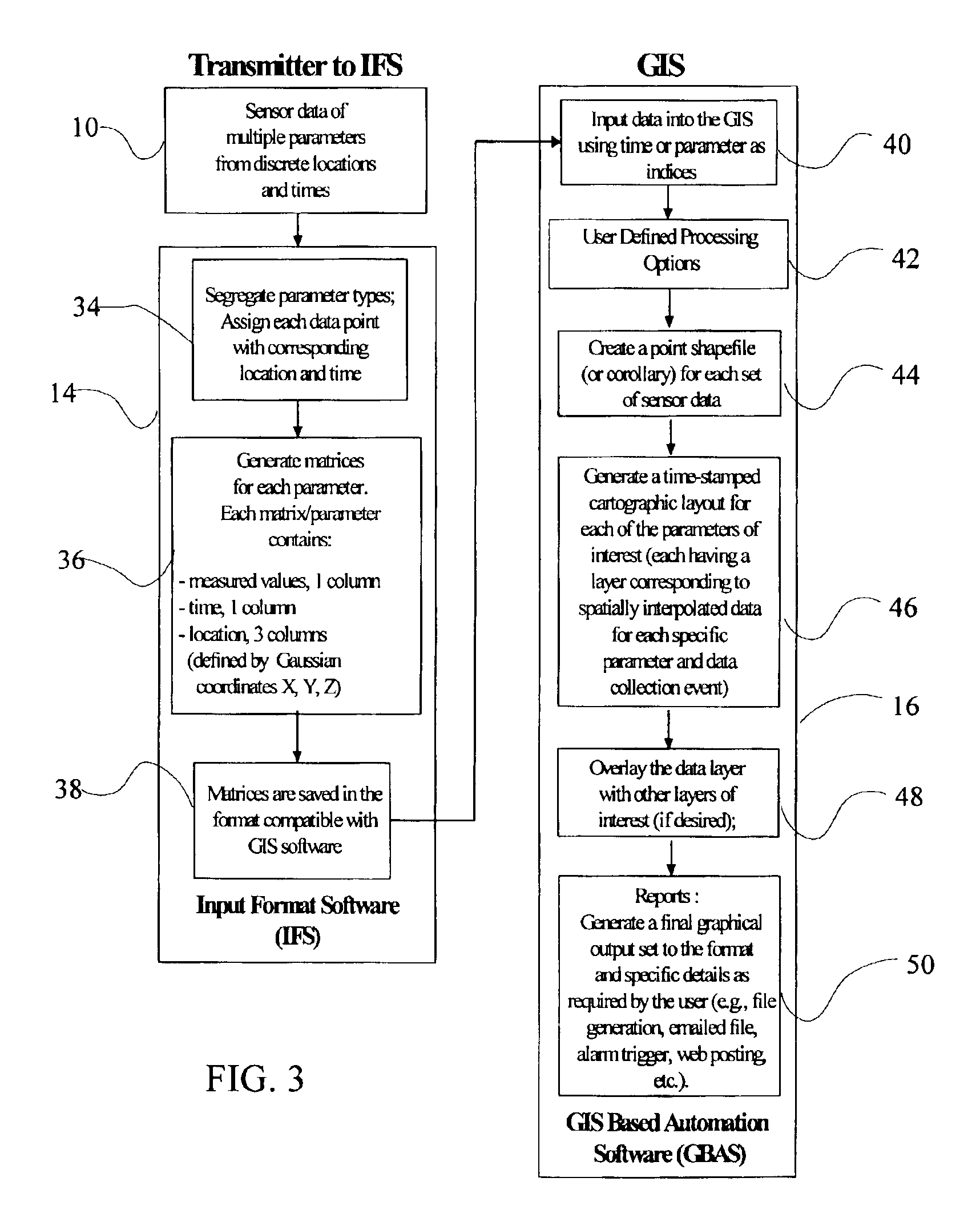
[0009]The present invention is a geographical information system (GIS) based automated software (GBAS) system, which converts real-time sensor information from sensor data transmission terminals into real-time sensor data and site map representations. Remote monitoring systems of remote sensor bundles provide data for the system. Sensor data is processed to automatically generate report-quality graphical and electronic output, allowing for rapid decision-making capabilities.
[0011]Data can be displayed as layers for map algebra and allow for detailed spatial analyses such as detecting trends in a given time series, evaluating averages over a given time period, monitoring time lapse images for a given time step, and for determining dependent variables in multivariate interactions. In addition, video clips for animation are imbedded into electronic formats for generating presentations and reports. This novel system allows for significant cost-savings, more comprehensive data sets, more flexibility in data management and presentation, removes the need for manual data entry, and reduces the potential for human and ecological toxic exposure.

Problems solved by technology

If a leak occurs, these materials can enter the subsurface and contaminate ground water resources, requiring expensive assessment and remediation efforts.
It is estimated that a significant proportion of the nearly five million tanks in the United States are leaking harmful products into the environment.
At present, costs for monitoring a typical toxic release site ranges from $15000 to over $200,000 per year using conventional techniques.
Several thousand contaminated ground water sites are currently being monitored by the Department of Defense and Department of Energy, typically requiring hundreds of millions of dollars per year.
However, there is nothing in the prior art integrating the data into a comprehensive database structure aimed at tracking trends and making decisions.

Method used


Image

  • GIS based real-time monitoring and reporting system
  • GIS based real-time monitoring and reporting system
  • GIS based real-time monitoring and reporting system

Examples


Embodiment Construction

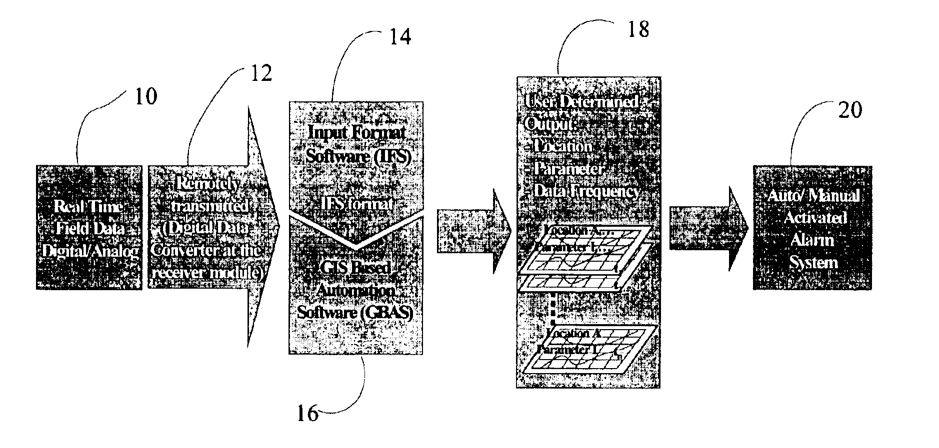
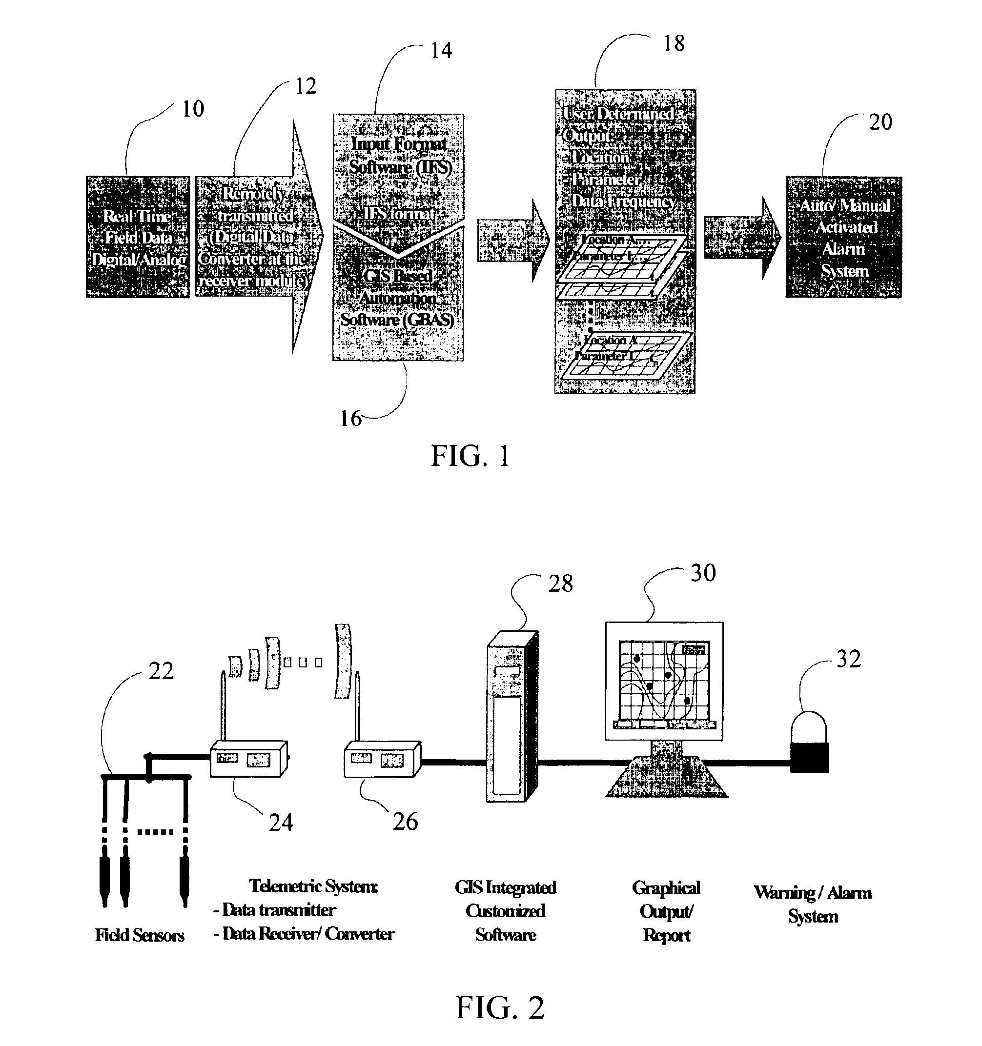
[0019]Referring to the drawings beginning with FIG. 1, the invention is embodied in a system employing real-time field data sensors 10 connected for remote transmission 12 to provide data to two software elements; a sensor data input formatting system 14 and software code imbedded into a standard geographical information system (GIS) 16. The software elements are employed to process the real-time sensor data and yield site map representations 18. The software uses statistical rendering to read data from each sensor location at a specific time, in real-time, with storage for report output. The benefits of the system are substantial in that one can convert point data to GIS surfaces, allowing for many types of spatial analyses, such as queries with other surfaces and map calculations among others, without the need for manual data entry. An alarm system 20 can be activated automatically or manually based on the interpreted data.

[0020]A system incorporating the present invention allows ...


PUM


Abstract

A monitoring and reporting system employing field sensor packages with telemetry to a processing system having input software creating cardinal matrices for the sensor data and conversion elements for compatibility with a geographical information system (GIS) to produce real-time generate geostatistically rendered contour diagrams that display the spatial and temporal distribution of environmental parameters of interest.

Description

CROSS-REFERENCE TO RELATED APPLICATIONS[0001]This application claims priority of Provisional Application Ser. No. 60 / 370,304 entitled “Integrated Sensor System” filed on Apr. 5, 2002 and Provisional Application Ser. No. 60 / 424,641 entitled “Automation Software for GIS Based Real-Time Monitoring and Reporting System” filed on Nov. 6, 2002, the disclosures of which are incorporated by reference as though fully set forth.NOTICE OF RETENTION OF COPYRIGHT[0002]Certain software programs or routines disclosed in this application are subject to copyright protection and all rights thereto are specifically reserved. No dedication to the public of those copyrights is intended or made by such disclosure in this specification.BACKGROUND OF THE INVENTION[0003]1. Field of the Invention[0004]This invention relates generally to the field of automated systems for monitoring and detecting the presence of contaminant materials, indicator parameters, and measurements related to fate and transport in ord...

Claims


Application Information

Patent Timeline
IPC IPC(8): G08B21/00G06Q50/00G06Q99/00G08B21/10
CPCG06Q10/02G06Q50/00G06Q99/00G08B21/10
Inventor KRAM, MARKSIRIVITHAYAPAKORN, SANYABEIGHLEY, II, RALPH EDWARD
Owner GROUNDSWELL TECH LLC
Learn More