Location identifying apparatus and method of identifying the location of a user

Inactive Publication Date: 2006-06-13
TRIMBLE NAVIGATION LTD
View PDF14 Cites 22 Cited by
  • Summary
  • Abstract
  • Description
  • Claims
  • Application Information

AI Technical Summary

Benefits of technology

[0009]The present invention provides for a system, such as a surveying system, for determining the location of a mobile station. In

Problems solved by technology

However, GPS has limited accuracy.
This limits the versatility of the system, since different wireless data link technologies are appropriate for different s

Method used


Image

  • Location identifying apparatus and method of identifying the location of a user
  • Location identifying apparatus and method of identifying the location of a user
  • Location identifying apparatus and method of identifying the location of a user

Examples


Embodiment Construction

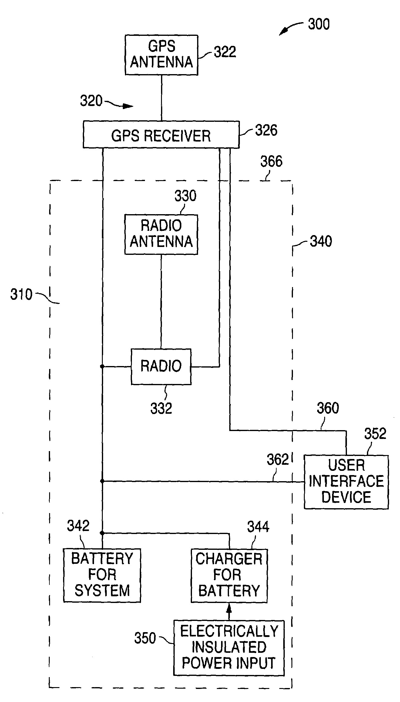
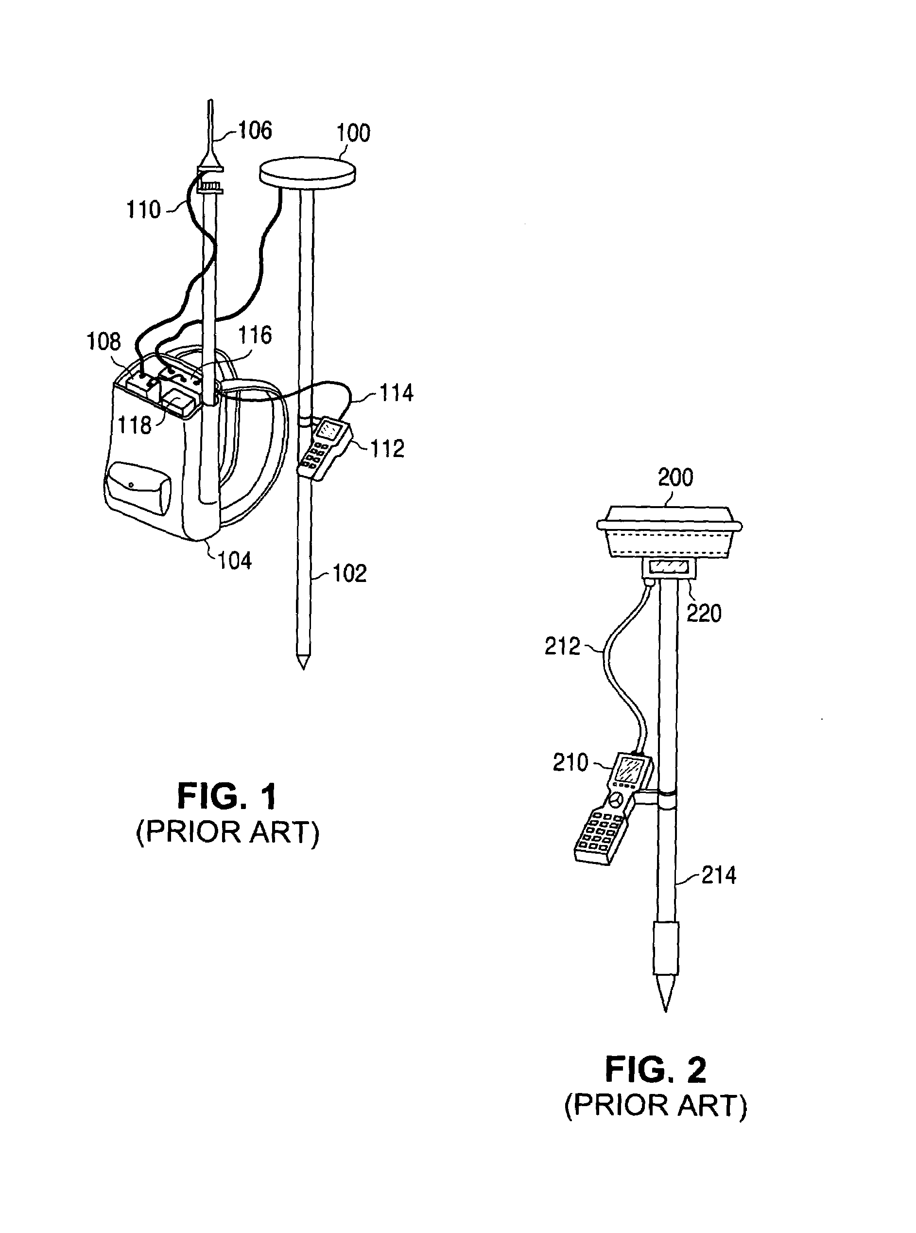
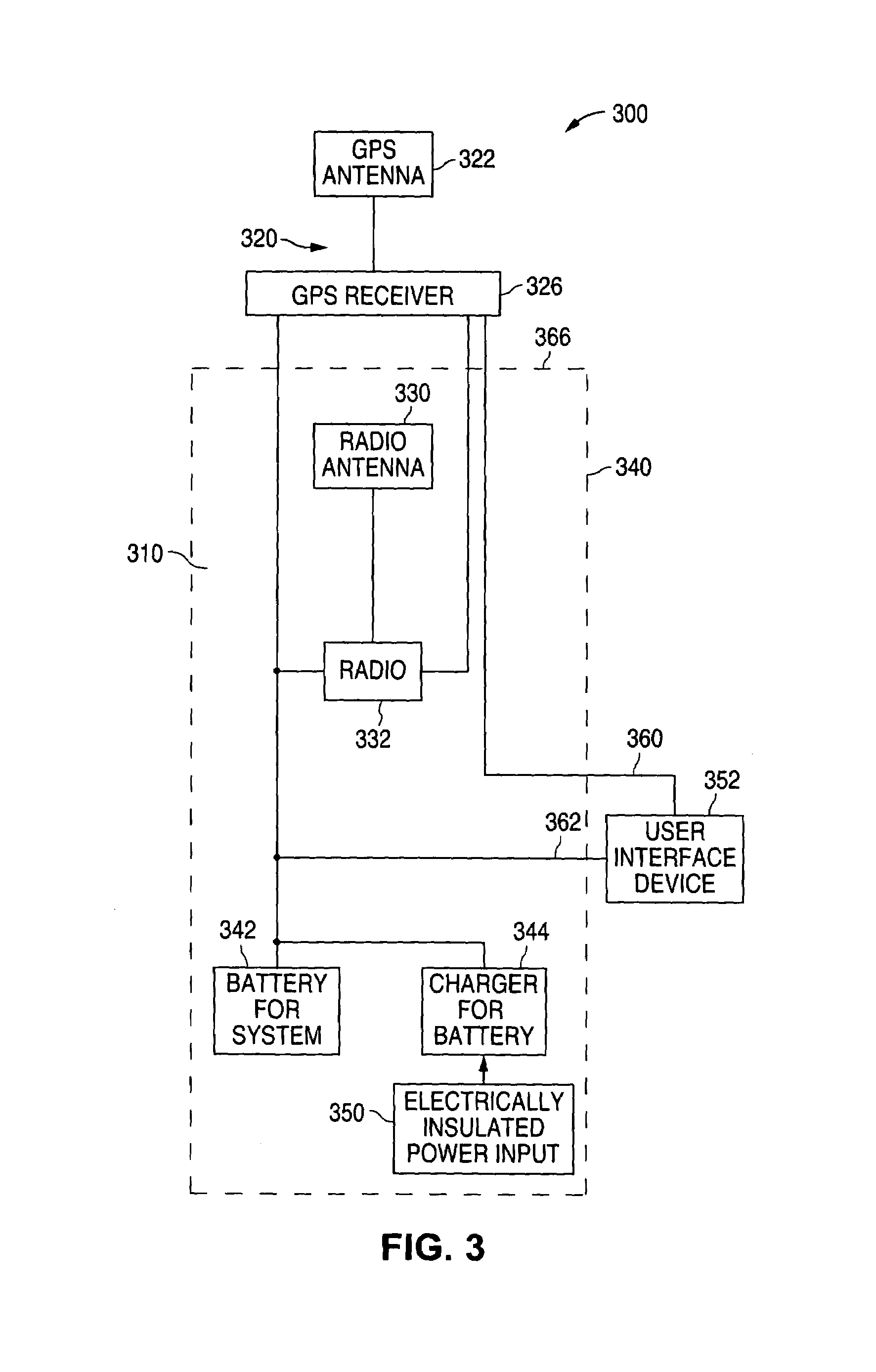
[0032]FIG. 3 is a block diagram, and FIG. 4 is a three dimensional view of one embodiment of a rover or mobile station of a differential global positioning system (DGPS) of the invention. The mobile station 300 comprises two major systems: a radio or wireless data link system 310 and a Global Positioning System (GPS) 320. The GPS 320 receives GPS signals from a satellite by means of a GPS antenna 322 connected to a GPS receiver 326. This information is corrected using differential correction data received from a base station (not shown) by means of a radio antenna 330 connected to a radio receiver or transceiver 332. For ease of reference, the same reference numerals are used as far as possible in the physical depiction of FIG. 4.

[0033]In accordance with one embodiment of the invention, the radio system 310 with its radio receiver or transceiver 332 and radio antenna, is housed within a tubular survey pole 340. In this embodiment, the power supply for the systems 310, 320 takes the ...


PUM


Abstract

In a survey system involving either differential global positioning (DGPS) or robotic total station (RTS) systems, the mobile station includes the radio system in the surveyor pole and either connects the laser reflector system or the GPS to the top of the pole or provides a connector for releasably connecting the laser reflector system or GPS. Electric connections between the GPS or laser reflector system, and the radio system are made either by using the physical connector between the pole and the GPS or laser reflector system, or by providing separate electrical conductors and electrical connectors from the pole to the GPS or laser reflector. In the case of a RTS system the base station includes a GPS for locating the position of the base station. For added convenience, the pole may be formed in sections and the power supply may include an inductive coupling battery charger. Data communications may also take place using wireless technology such as Bluetooth.

Description

[0001]Continuation-in-part (CIP) of prior application Ser. No. 09 / 663,063 filed Sep. 15, 2000.FIELD OF THE INVENTION[0002]The invention relates to a system for identifying a location on the earth's surface and more particularly to Differential Global Positioning System (DGPS), Geographic Information System (GIS), and Robotic Total Station (RTS) Systems.BACKGROUND OF THE INVENTION[0003]Several systems and methods exist for identifying the position of a user and for performing surveying tasks in which the position of a mobile station has to be determined to varying degrees of accuracy.[0004]One such system makes use of Global Positioning System (GPS) to determine the location of a mobile station. However, GPS has limited accuracy. As a result, systems have been developed to increase GPS accuracy by establishing a reference and identifying the degree of error, which is then used to correct the readings of other GPS systems. This is referred to as Differential GPS (DGPS). Real Time Kine...

Claims


Application Information

Patent Timeline
IPC IPC(8): H04M1/00G01S19/44G01S19/04G01S19/10G01S19/46
CPCG01C15/00G01S19/35G01C15/06
Inventor CAMERON, JOHN F.SELLERS, MARK D.
Owner TRIMBLE NAVIGATION LTD
Why Eureka
Try Eureka