Method and system for real time navigation using satellite transmitted three-carrier radio signals and ionospheric corrections

a technology of satellite transmission and radio signal, applied in the field of real-time navigation using satellite transmitted three-carrier radio signal and ionospheric correction, can solve the problems of increasing the cost of the global system, aircraft, and inability to accurately determine the position of the rover, so as to reduce the number of reference stations, and improve the performance

Active Publication Date: 2007-08-14
EUROPEAN SPACE AGENCY
View PDF5 Cites 19 Cited by
  • Summary
  • Abstract
  • Description
  • Claims
  • Application Information

AI Technical Summary

Benefits of technology

[0033]The capabilities specific to the invention make it possible to obtain better performance than the “ITCAR” method over long distances, at a position very far from the nearest reference station. The method according to the invention typically allows the instantaneous resolution of more than 90% of ambiguities at more than 100 kilometers from this station, and practically 100% at a distance on the order of 60 km, even in an operating scenario that is not very favorable: low ionospheric values and maximum sunlight conditions. Under comparable conditions, the methods of the prior art using three frequencies achieve a typical success rate that is only on the order of 60%.
[0034]It is easy to see that this latter characteristic is very advantageous, since it does not require the installation of a very dense network of fixed ground reference stations (stations on the order of a hundred kilometers apart). The result is a very substantial overall savings, for example in the case of Europe: in covering that continent, it is possible to reduce the number of reference stations by 99% compared to a network wherein the reference stations are only separated by a distance on the order of ten kilometers, while retaining the same precision in the determination of a rover's position as that obtained by the methods of the prior art. This is in fact the installation density required to obtain a navigation precision better than one decimeter, as sought by method of the invention in its preferred application. Moreover, the network of fixed ground reference stations required by the method of the invention is very similar to the network currently being installed for the European satellite navigation system known by the abbreviation “EGNOS GNSS” (for “European Geostationary Navigation Overlay System—Global Navigation Satellite Systems”). This system is based on a constellation of “IMMERSAT III” satellites, which suggests that there is substantial compatibility with the installations that currently exist or are in the process of being installed.

Problems solved by technology

However, as will be shown, because of the accumulation of errors in the measurements due to various causes, the distances calculated are only approximate, and the determination of the position of the rover suffers from a more or less substantial degree of imprecision, depending on the technologies used.
However, while the latter method does not present any major drawbacks for slow-moving rovers (ships, for example), it is not appropriate for rovers that move very fast (aircraft, for example).
However, if the rover travels great distances, it is necessary for this network of stations to be relatively dense, especially in cases where high precision is desirable in the determination of the rover's position, which correspondingly increases the cost of the global system.
Moreover, among the numerous causes of errors, differential ionospheric refraction, when considering distances equal to tens of kilometers or more, is one of the main problems affecting capacities for instantaneous resolution of carrier phase ambiguity, and consequently the capability to provide a navigation wherein the precision is on the order of one centimeter with dual-frequency global navigation satellite systems such as the aforementioned “GPS” system.
But here again, this resolution can be seriously affected by ionospheric refraction, as explained below.
But the performance of “TCAR” is strongly affected by the ionospheric refraction decorrelation that occurs with distance.
However, although it provides a significant improvement, the “ITCAR” technique is nonetheless still affected by the lack of knowledge of the double difference of the ionospheric refraction, thus limiting the success rate of the ambiguity resolution for distances greater than several tens of kilometers, as described in the article by VOLLATH et al., entitled “Ambiguity Resolution Using Three Carriers—Performance Analyzing Using ‘Real’ Data, published in “GNSS Symposium,” Seville, May 2001.

Method used


Image

  • Method and system for real time navigation using satellite transmitted three-carrier radio signals and ionospheric corrections
  • Method and system for real time navigation using satellite transmitted three-carrier radio signals and ionospheric corrections
  • Method and system for real time navigation using satellite transmitted three-carrier radio signals and ionospheric corrections

Examples


Embodiment Construction

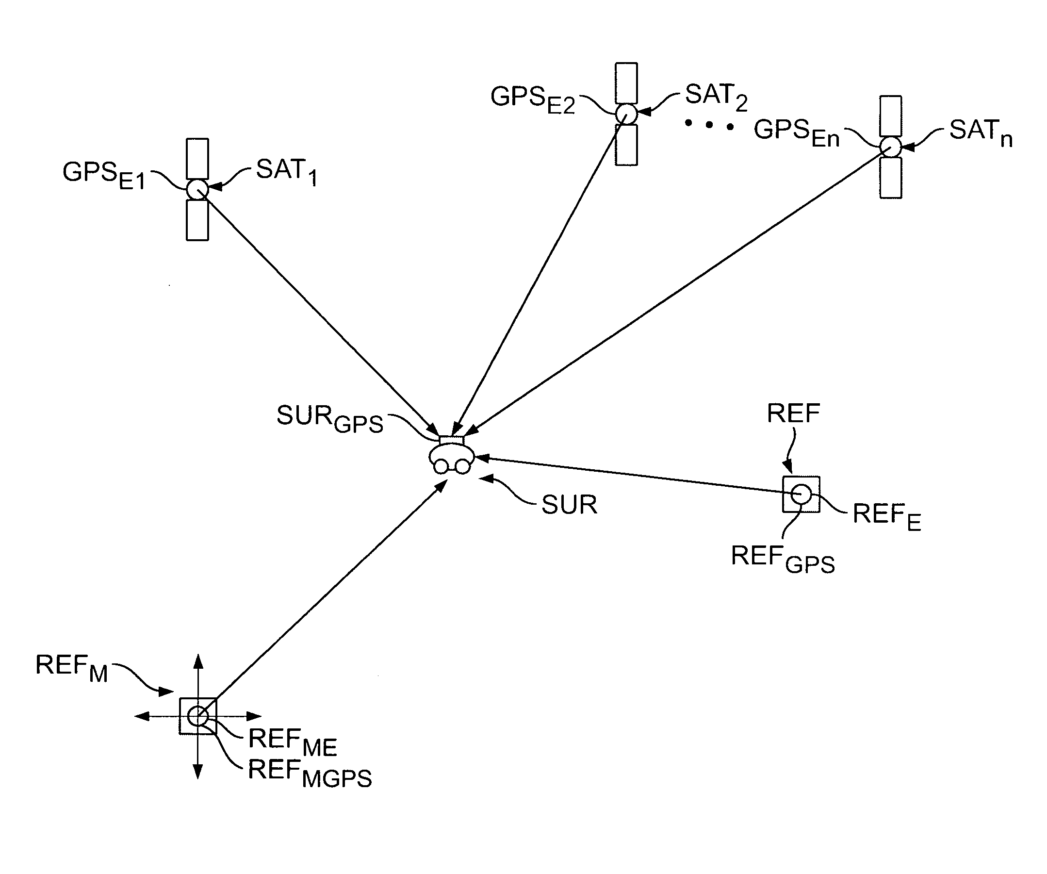
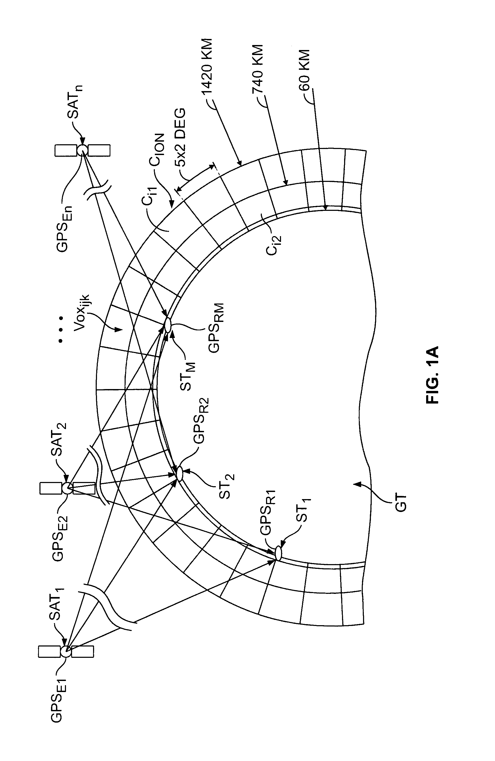
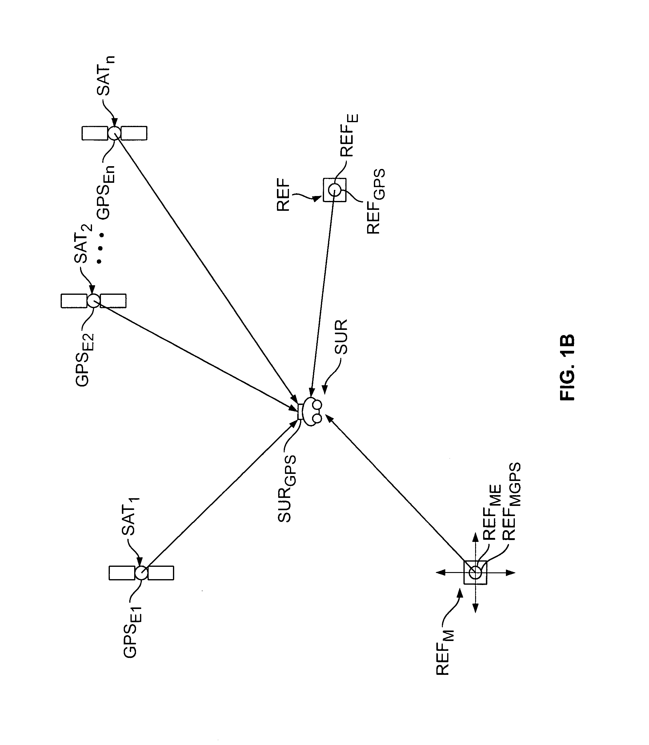
[0055]Hereinafter, without in any way limiting the scope of the invention, we will focus on the context of its preferred application unless otherwise indicated, i.e., on the case of a high-precision satellite navigation method using three-carrier radio waves of different frequencies transmitted by satellites, and real-time corrections derived from a descriptive real-time ionospheric model of a region sounded by radio frequency radiation from satellites.

[0056]We will now describe the main steps of the method according to the invention in detail, using typical numeric values to illustrate them. It comprises three basic steps, which are similar to those of the aforementioned “TCAR” method and are explained below:[0057]Step 1:

[0058]In order to resolve the so-called “extra wide lane” ambiguity (with a typical wave-length of 7.5 meters in a data set of a given exemplary experiment), a combination of codes known as “pseudoranges” is added.

[0059]Among the known causes of errors is the so-ca...


PUM


Abstract

The invention concerns a real-time navigation method for locating a rover using three-carrier radio signals of three different frequencies to determine the position of a user, transmitted by satellites. The method comprises a first step for determining “extra-wide lane” carrier phase ambiguity, a second step for estimating “wide-lane” phase ambiguity, and a third step for resolving the phase ambiguity of one of the frequencies. An additional step consists in the application of real-time ionospheric corrections during the third step, these ionospheric corrections being based on a continuously updated ionospheric model of said ionospheric layer calculated by a fixed ground reference station combined with geodetic data calculated by a so-called master fixed ground reference station. The invention also concerns a system for implementing the method.

Description

[0001]This application is a §371 from PCT / FR2003 / 050176 filed Dec. 16, 2003, which claims priority from FR 0216227 filed Dec. 19, 2002, each herein incorporated by reference.BACKGROUND OF THE INVENTION [0002]The invention concerns a method and a system for real-time navigation using satellite-transmitted three-carrier radio signals and ionospheric corrections, more precisely corrections obtained by means of a continuously updated real-time ionospheric model, the model being based on data from a satellite navigation system, for example implemented like a three-dimensional voxel model.[0003]It is particularly though not exclusively, applicable to the field of high-precision instantaneous navigation, typically having a precision within one decimeter, as will be shown below, at distances on the order of hundreds of kilometers or more.[0004]By way of illustration, we will hereinafter focus on the preferred application of the invention, without in any way limiting its scope.[0005]One of t...

Claims


Application Information

Patent Timeline
Patent Type & Authority Patents(United States)
IPC IPC(8): G01S5/14G01S19/10G01S1/00G01S19/07G01S19/13G01S19/29G01S19/32G01S19/44
CPCG01S19/32G01S19/44G01S19/072
Inventor HERNANDEZ-PAJARES, MANUELJUAN-ZORNOZA, JOSE MIGUELSANZ-SUBIRANA, JUAMEGARCIA-RODRIGUEZ, ALBERTO
Owner EUROPEAN SPACE AGENCY
Why Eureka
Try Eureka