Spectral imaging system

a spectral imaging and imaging system technology, applied in the field of spectral imaging systems, can solve the problems of not disclosing the use of light or imaging, the use of any second-order filter, and the inability to use the dynamic range of oceanographically obscured environmental media, etc., and achieve the challenge of the environment for the development of remote sensing instruments and algorithms

Inactive Publication Date: 2008-05-06
EATHON INTELLIGENCE
View PDF0 Cites 55 Cited by
  • Summary
  • Abstract
  • Description
  • Claims
  • Application Information

AI Technical Summary

Benefits of technology

[0012]A system for remotely sensing coastal marine environments is useful for imaging many different environments that require information to be gathered from images obscured by intervening environmental media. The system comprises a calibrated spectral imaging sensor. The method for calibrating the spectral imaging sensor may use filters to extend the radiometric calibration range and a calculation that accounts for the filter effect on all viewing angles of the spectral imaging sensor. In one embodiment, a radiometric calibration map is derived, using data collected using filters, that is applied to the signals from the passive spectral imaging sensor by the imaging system. For example, a correction may be included in the map for the residual stray light and frame transfer smear in any data stream produced by the passive spectral imaging sensor, such that the passive spectral imaging sensor accurately detects the frequencies of light for elements of interest from a variety of different obscuring media, such as a marine environment.
[0015]Passive spectral imaging of the electromagnetic radiation from the target and media uses a continuous broad wavelength of electromagnetic radiation such as natural sunlight to illuminate the elements of interest and the environment. Spectral imaging defines a technology whereby the individual electromagnetic responses of elements found within a scene are captured and recorded. Spectral imaging incorporates any spectroscopy technique employing multiple wavelengths. The active imaging of LIDAR (Light Detection And Ranging) uses spectrally narrow pulses of electromagnetic radiation which are emitted by the sensor and the return signal is measured with time-of-flight techniques such as time gating and ranging. This allows retrieval of target characterization and classification from any fluid or obscured medium by combining information regarding both the spectral signature of the elements of interest and the location of the elements of interest within the fluid medium.
[0017]Extraction of environmental information, such as water inherent optical properties (IOPs) and shallow-water bottom depth (zb) and spectral reflectance (Rb) from remotely-sensed hyperspectral ocean-color data, uses a look-up-table (LUT) approach, in one example that compares a measured remote-sensing reflectance (Rrs) spectrum with tabulated Rrs spectra generated by a large number of numerical radiative transfer modeling runs. The runs use a wider range of water IOPs, bottom depths and reflectances, solar angles and viewing directions. The environmental conditions corresponding to the measured Rrs spectrum are presumed to be the same as the input conditions for the radiative transfer modeling run that generated the database Rrs spectrum. LUT method works very well. Non-uniqueness of Rrs spectra does not appear to be a problem, and wavelength-uncorrelated random noise does not affect the spectrum matching.

Problems solved by technology

The '492 patent does not disclose the use of light or imaging or the use of any second order filters.
Instead, the '492 patent teaches numerically correcting for second order of effects, disclosing the use of merely a 10 bit CCD system, which has an inadequate dynamic range for use in oceanographically obscured environmental media.
The complexity and variety of marine optical signals in coastal ocean areas has created a challenging environment for the development of remote sensing instrumentation and algorithms.
While these algorithms have worked well for classifying marine water types, they have been less successful in describing near shore environments.
The algorithms are also hampered by colored degradation matter and sediments from terrestrial sources that contaminate the marine produced color signals.
Additionally, the increased development along the world's coastal boundaries adds another layer of complexity for determining concentration and interactions between the marine and terrestrial aerosols.
As opposed to deeper off shore waters, the assumption that these waters have no optical return in the near infra red is no longer valid.
These considerations coupled with the dominance of the atmosphere's optical effects over the weak optical return from the coastal environment make atmospheric correction of these coastal areas very difficult.
However, the sensors used to collect the data for these previous studies suffer from sensitivity and calibration issues that become apparent in these low light scenes.
The instruments' limitations require an on-site, vicarious calibration of the data to be useful in these environments.
This in turn, reduces the applicability of these tools and techniques to other coastal areas, or even other water-types within the same image.
In addition, remote sensing data analyses, such as temporal scene-to-scene comparisons, are virtually impossible to interpret if the physical units of the individual images are in question.

Method used


Image

  • Spectral imaging system
  • Spectral imaging system
  • Spectral imaging system

Examples


Embodiment Construction

[0038]This detailed description and the drawings provides specific examples of the invention, but the invention should not be limited merely to the examples disclosed. Instead, the invention should be limited only by the claims that may eventually issue. Many variations in the system, changes in specific components of the system and uses of the system will be readily apparent to those familiar with the area of remote sensing based on the drawings and description provided.

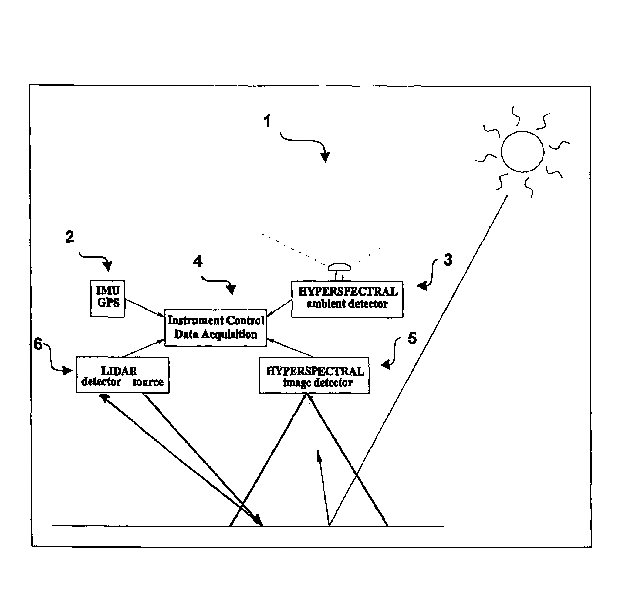
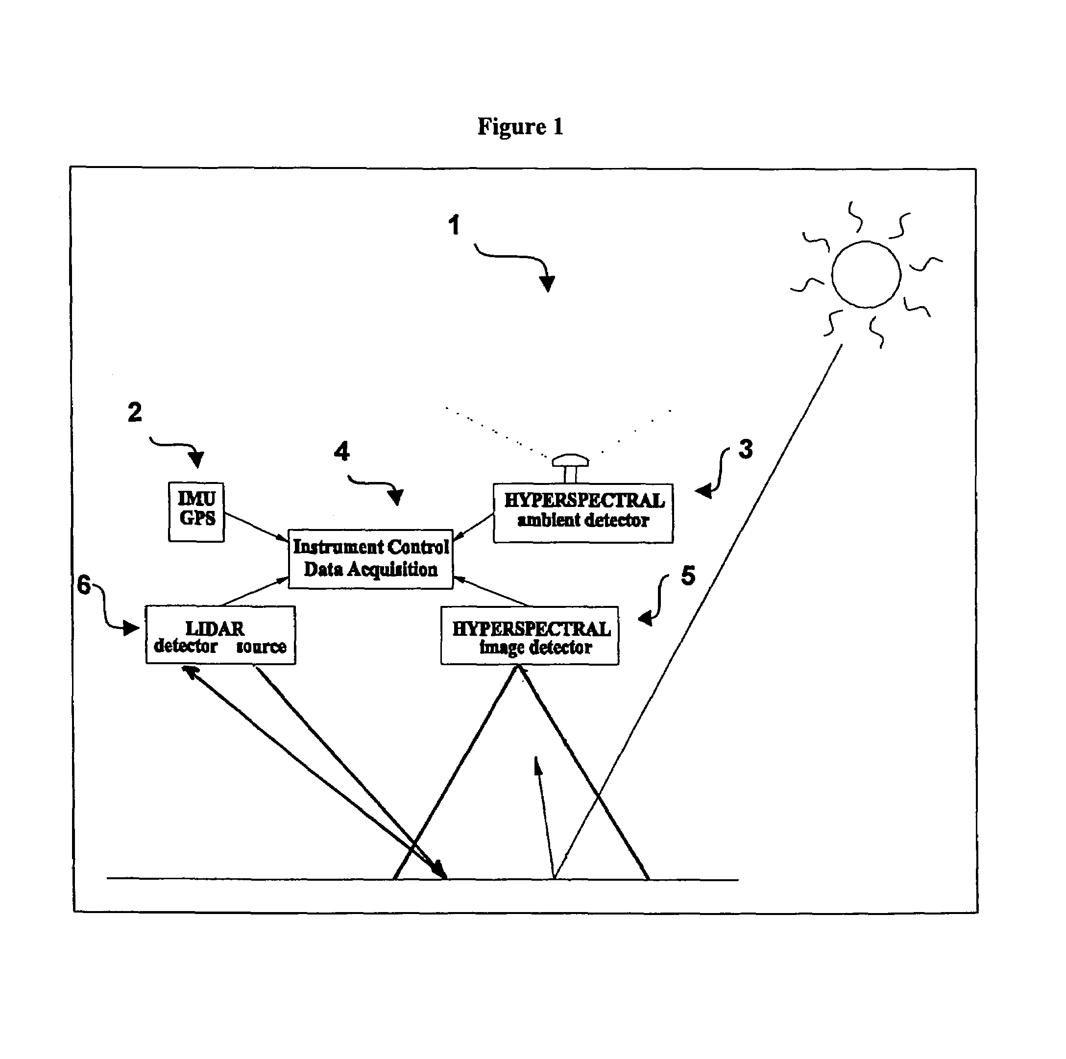
[0039]In one embodiment, a system of remotely sensing coastal marine environments is developed that has the capability of coupling a multispectral imaging sensor and a LIDAR system to improve the resulting information obtained on elements of interest within the coastal marine environment, such as shown in FIG. 1.

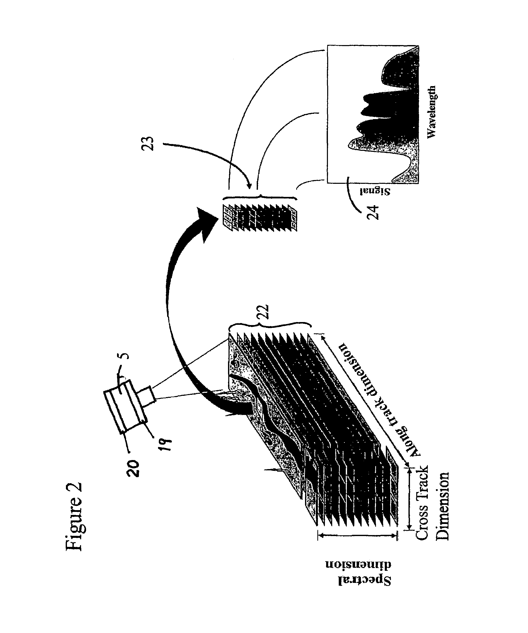
[0040]One embodiment includes a device and method for calibrating a spectral imaging camera. The system may also include a method for processing remotely sensed, multi-spectral data, such as the capability o...


PUM

PropertyMeasurementUnit
quantum efficiencyaaaaaaaaaa
frequenciesaaaaaaaaaa
scanning frequencyaaaaaaaaaa

Abstract

An imaging system and methods for resolving elements of interest through and obscuring environment by removing undesired signals from the intervening, obscuring environment is disclosed. A passive hyperspectral imaging sensor is calibrated and integrated into a system having a positioning and attitude detection system and an instrument control and data acquisition system that records data from sensors in a three-dimensional data cube having two spatial dimensions and a spectral dimension. Either an active detection and ranging system or a look-up-table approach or both are used to remove the noise generated by the intervening, obscuring environment from the data relevant to the elements of interest.

Description

RELATED APPLICATIONS[0001]This application claims the benefit of Provisional Application No. 60 / 525,192, filed Nov. 26, 2003; Provisional Application No. 60 / 545,803, filed Feb. 19, 2004 and Provisional Application No. 60 / 563,967, filed Apr. 21, 2004.FIELD OF THE INVENTION[0002]The spectral imaging system relates to systems for gathering information about features obscured by intervening environmental media.BACKGROUND[0003]Systems that use airborne platforms for imaging, such as satellites, aircraft and dirigibles, which are lighter than air at sea level, in order to remotely gather information are known. Passive spectral imaging of electromagnetic radiation, using natural sunlight as the illumination source, is capable of resolving information about elements of interest through a radiation obscuring media. Spectral imaging is a technology defined by the capturing and recording the electromagnetic radiation reflected and / or emitted from elements of interest. Conventional sensors focu...

Claims


Application Information

Patent Timeline
Patent Type & Authority Patents(United States)
IPC IPC(8): G01J3/28G01N21/27G01N21/31G01S17/86
CPCG01J3/28G01J3/2823G01N21/274G01N21/31G01S17/023G01J2003/2866G01N2021/1793G01N2021/1797G01J1/4204G01S17/86
Inventor BISSETT, III, WILLIAM PAULKOHLER, DAVID D. R.STEWARD, ROBERT G.MOBLEY, CURTIS D.
Owner EATHON INTELLIGENCE
Why Eureka
Try Eureka