Communications link time transfer to improve navigation system accuracy

a technology of communication link and navigation system, applied in the field of navigation system and global navigation satellite system, can solve the problems of limited performance improvement possibilities, poor vertical accuracy of gps, clustering of available satellites, etc., and achieve the effect of improving satellite navigation capability, significant accuracy improvement, and extending

Active Publication Date: 2010-03-16
ROCKWELL COLLINS INC
View PDF2 Cites 10 Cited by
  • Summary
  • Abstract
  • Description
  • Claims
  • Application Information

AI Technical Summary

Benefits of technology

[0009]It is an advantage of the present invention to use a two-way communications link, which in addition to serving as the differential data link, is being used as an auxiliary sensor.
[0010]It is an advantage of the present invention to provide significant accuracy improvements with poor satellite geometries.
[0011]It is a feature of the present invention to extend, satellite navigation capability into more challenging operational environments.
[0012]It is a feature of the present invention to extend to applications in other satellite navigation systems and ground based two-dimensional systems.

Problems solved by technology

With few exceptions, GPS vertical accuracy is generally poorer than its horizontal accuracy.
This is particularly acute at raised masked angles that constrict the visible sky and lead to clustering of the available satellites.
For airborne applications that require vertical accuracy for guidance and control, but are saddled with operational environments of restricted satellite visibility, previous efforts have been focused primarily on lowering the range error or raising the number of ranging sources, both of which give only limited possibilities for performance improvement.
However, heliports and tactical landing strips can sometimes be at locations with some restricted visibility.
Assisted GPS and E-911 applications in indoor environments where signal strength inside a building is very poor, so available signals are sparse and provide poor VDOP and HDOP, is another application.

Method used


Image

  • Communications link time transfer to improve navigation system accuracy
  • Communications link time transfer to improve navigation system accuracy
  • Communications link time transfer to improve navigation system accuracy

Examples


Embodiment Construction

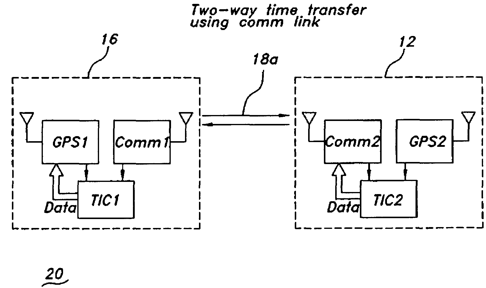
[0023]The present invention is for a method and apparatus for communications link time transfer to improve positioning accuracy in a differential navigation system. A high-precision time transfer method uses an independent two-way communication link for time transfer from a reference station to achieve nanosecond-level relative timing accuracy. Improved relative clock error in an aircraft or other remote station with respect to the reference station reduces dilution of precision (DOP) and improves positioning accuracy.

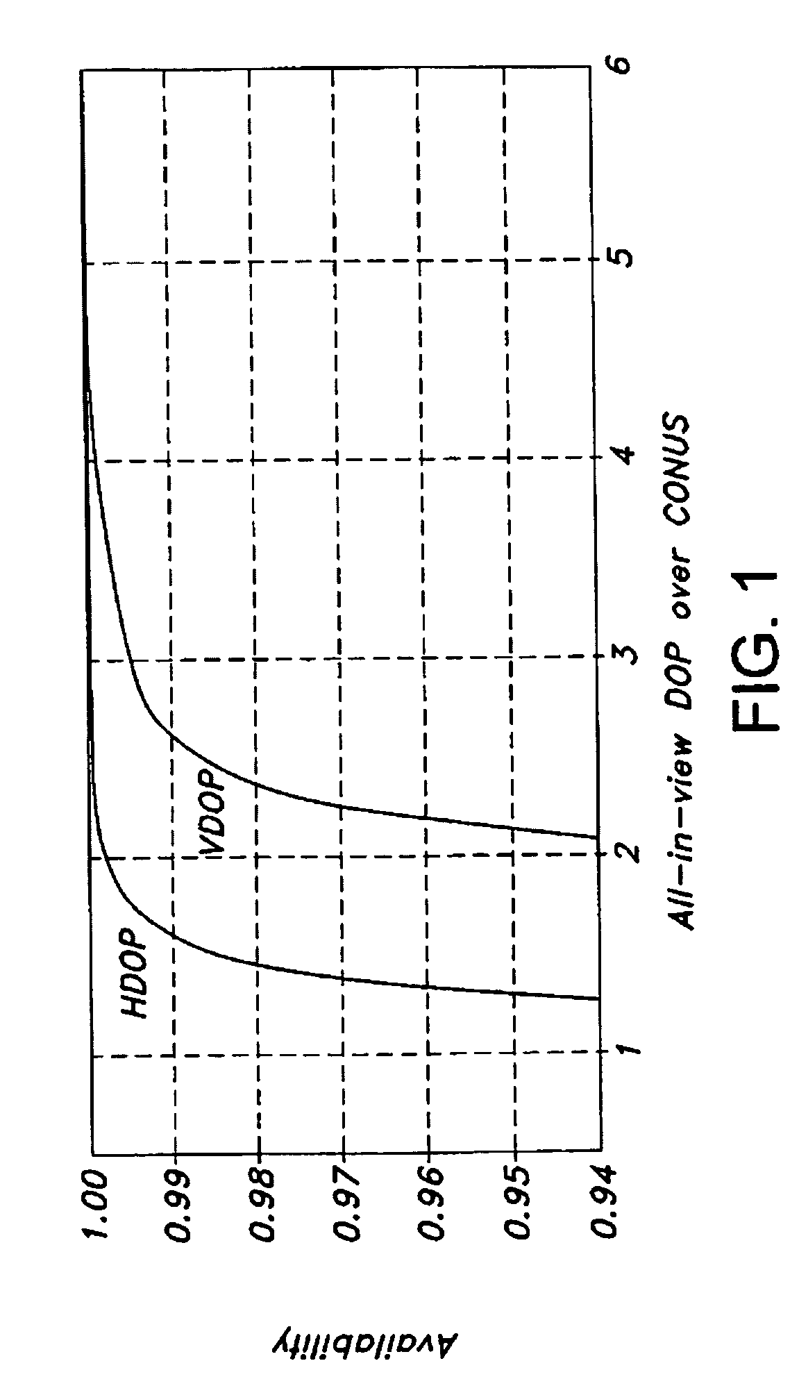
[0024]The present invention is applicable to but not limited to GNSS, GPS, and other passive ranging navigation systems such as Loran. The present invention is applicable to future navigation systems that use non-navigation signals of opportunity. The present invention is described herein in terms of a GPS system and specifically a differential GPS (DGPS) system. The invention is described below for improving the vertical dilution of precision (VDOP) but may be used to...


PUM


Abstract

A method and apparatus for improving differential navigation accuracy uses time transfer over a two-way communications link. The communications link transmits an overall time offset between a differential reference station and a remote user. A differential navigation position solution is modified at the remote user with the overall time offset to improve the differential navigation accuracy. A first time offset between a first communications device and a first navigation receiver at the remote user is determined. A second time offset between the first communications device at the remote user and a second communications device at the differential reference station is determined. A third time offset between the second communications device and a second navigation receiver at the differential reference station is determined. An overall time offset from the first time offset, the second time offset, and the third time offset is computed and used to improve the differential navigation accuracy.

Description

BACKGROUND OF THE INVENTION[0001]This invention relates to navigation systems, Global Navigation Satellite Systems (GNSS), the Global Positioning System (GPS), and specifically to a method of using a two-way communications link to improve differential navigation system accuracy.[0002]With few exceptions, GPS vertical accuracy is generally poorer than its horizontal accuracy. This is particularly acute at raised masked angles that constrict the visible sky and lead to clustering of the available satellites. A similar effect on horizontal accuracy is also found to be caused by clustering of satellites in a directional sense. For airborne applications that require vertical accuracy for guidance and control, but are saddled with operational environments of restricted satellite visibility, previous efforts have been focused primarily on lowering the range error or raising the number of ranging sources, both of which give only limited possibilities for performance improvement. Alternative...

Claims


Application Information

Patent Timeline
Patent Type & Authority Patents(United States)
IPC IPC(8): G01S5/14G01S1/00G01S19/15G01S19/41
CPCG01S19/15G01S19/41G01S19/235
Inventor HWANG, PATRICK YSCHNAUFER, BERNARD A.ANDERSON, DAVID A.MCGRAW, GARY A.
Owner ROCKWELL COLLINS INC
Why Eureka
Try Eureka